Georgia State Route 97
| ||||
|---|---|---|---|---|
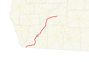 Georgia State Route 97 highlighted in red | ||||
| Route information | ||||
| Maintained by GDOT | ||||
| Length | 57.2 mi[1] (92.1 km) | |||
| Major junctions | ||||
| South end |
| |||
|
| ||||
| North end |
| |||
| Location | ||||
| Counties | Decatur, Mitchell | |||
| Highway system | ||||
| ||||

State Route 97 (SR 97) is a southwest-northeast state highway in the southwest part of the U.S. state of Georgia. The highway runs 57.2 miles (92.1 km) from its southern terminus at the Florida state line, southwest of Faceville, where the roadway continues as County Road 269A, northeast through Bainbridge to its northern terminus, in Camilla.
Route description
Decatur County
SR 97 begins at the Florida state line, where the roadway continues as County Road 269A (CR 269A). Northeast of the state line, the highway has an intersection with SR 97 Spur. Farther northeast, in Faceville, the highway intersects SR 302 Spur. Just northeast of the community is an intersection with SR 302. After this, the highway heads to Bainbridge.
Just inside the city limits, there is an intersection with SR 97 Conn. US 27/US 84/SR 38 is the next intersection along the path. Just after the intersection is SR 309, which begins a concurrency through the city. Eight blocks later, US 84 Bus./SR 38 Bus. briefly join the concurrency. About a block later, US 84 Bus./SR 38 Bus. leave the concurrency, SR 97 Conn. ends, and US 27 Bus./SR 1 Bus. join the concurrency. About seven blocks later, US 27 Bus./SR 1 Bus. leave the concurrency. Northeast of here, is the first intersection with SR 311.
3 miles (4.8 km) later, SR 309 departs the concurrency The roadway continues to the northeast, to an intersection with SR 262. The two routes have a brief concurrency into town.
Mitchell County
After leaving Vada, the route heads northeasterly to an intersection with SR 65 in the town of Hopeful. About 2 miles (3.2 km) later, is the second intersection with SR 311. The route heads easterly, to an concurrency with SR 112 in the city of Camilla. In downtown, the route meets its northern terminus at SR 37.[1]
Major intersections
| County | Location | mi[1] | km | Destinations | Notes |
|---|---|---|---|---|---|
| Decatur | | 0.0 | 0.0 | Florida state line | |
| | 6.5 | 10.5 | former SR 310 | ||
| Faceville | 9.9 | 15.9 | |||
| | 11.2 | 18.0 | |||
| Bainbridge | 20.3 | 32.7 | |||
| 21.2 | 34.1 | interchange | |||
| 21.5 | 34.6 | Southern end of SR 309 concurrency | |||
| 22.2 | 35.7 | Southern end of US 84 Bus. / SR 38 Bus. concurrency | |||
| 22.2 | 35.7 | Northern end of US 84 Bus./SR 38 Bus. and SR 97 Conn. concurrencies; southern end of US 27 Bus./SR 1 Bus. concurrency | |||
| 22.6 | 36.4 | Northern end of US 27 Bus. / SR 1 Bus. concurrency | |||
| 23.3 | 37.5 | ||||
| | 26.4 | 42.5 | north end of SR 309 overlap | ||
| | 37.5 | 60.4 | Southern end of SR 262 concurrency | ||
| Decatur–Mitchell county line | Vada | 38.5 | 62.0 | Northern end of SR 262 concurrency | |
| Mitchell | Hopeful | 45.0 | 72.4 | ||
| | 46.6 | 75.0 | |||
| Camilla | 56.4 | 90.8 | Southern end of SR 112 concurrency | ||
| 56.8 | 91.4 | Northern end of SR 112 concurrency | |||
| 57.2 | 92.1 | Northern terminus | |||
1.000 mi = 1.609 km; 1.000 km = 0.621 mi
| |||||
Special routes
Bainbridge connector route
| |
|---|---|
| Location | Bainbridge |
| Length | 1.4 mi[2] (2.3 km) |
State Route 97 Connector (SR 97 Connector) begins at an intersection with the SR 97 mainline, in the southern part of Bainbridge. It heads northeast, curves to the northwest and curves back to the northeast to meet its northern terminus, an intersection with US 84 BUS/SR 38 BUS in the western part of the city.[2]
Faceville spur route
| |
|---|---|
| Location | Southwest of Faceville |
| Length | 3.5 mi[3] (5.6 km) |
State Route 97 Spur (SR 97 Spur) begins at an intersection with the SR 97 mainline, southwest of Faceville. It heads northwest and ends at a barricade, just shy of the shores of Lake Seminole.[3]
See also
.svg.png)

References
- 1 2 3 Google (October 19, 2012). "Route of SR 97" (Map). Google Maps. Google. Retrieved October 19, 2012.
- 1 2 Google (October 19, 2012). "Route of SR 97 Connector" (Map). Google Maps. Google. Retrieved October 19, 2012.
- 1 2 Google (October 19, 2012). "Route of SR 97 Spur" (Map). Google Maps. Google. Retrieved October 19, 2012.
External links
![]()