Naylor, Georgia
| Naylor | |
|---|---|
| Unincorporated community | |
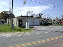 Naylor Volunteer Fire Department with Naylor Park in background | |
 Naylor Location within the state of Georgia  Naylor Naylor (the US) | |
| Coordinates: 30°54′31″N 83°4′42″W / 30.90861°N 83.07833°WCoordinates: 30°54′31″N 83°4′42″W / 30.90861°N 83.07833°W | |
| Country | United States |
| State | Georgia |
| County | Lowndes |
| Population (1990) | |
| • Total | 111 |
| Time zone | UTC-5 (Eastern (EST)) |
| • Summer (DST) | UTC-4 (EDT) |
| ZIP codes | 31641 |
Naylor is an unincorporated community in Lowndes County, Georgia, United States.[1] The community was named after Captain Naylor, a railroad man.[2]
Geography
Naylor is a circular area, one mile in diameter, located at the intersection of U.S. Route 84 and Georgia State Route 135. It is located approximately 9.5 miles east of Valdosta.
Demographics
As of the census of 1990, there were 111 people residing in the community. Naylor was unincorporated between the 1990 and 2000 census.
The community is in the 31641 zip code.
References
- ↑ "US Gazetteer files: 2010, 2000, and 1990". United States Census Bureau. 2011-02-12. Retrieved 2011-04-23.
- ↑ "ePodunk Naylor Community Profile". www.epodunk.com. Retrieved 2018-03-22.
Municipalities and communities of Lowndes County, Georgia, United States | ||
|---|---|---|
| Cities | 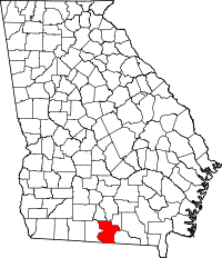 | |
| Town | ||
| CDP | ||
| Unincorporated communities | ||
This article is issued from
Wikipedia.
The text is licensed under Creative Commons - Attribution - Sharealike.
Additional terms may apply for the media files.