Georgia State Route 84
| ||||
|---|---|---|---|---|
| Grayson Parkway | ||||
 | ||||
| Route information | ||||
| Maintained by GDOT | ||||
| Length | 3.6 mi[1] (5.8 km) | |||
| Major junctions | ||||
| West end |
| |||
| East end |
| |||
| Location | ||||
| Counties | Gwinnett | |||
| Highway system | ||||
| ||||

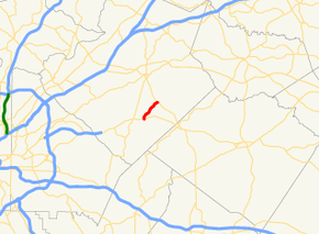
State Route 84 (SR 84) is a 3.6-mile-long (5.8 km) state highway, located entirely within Gwinnett County in the U.S. state of Georgia. It is Georgia's shortest two-digit state route.
Route description
SR 84 begins at an intersection with US 78/SR 10 in the southeastern part of Snellville. It heads northeast to the small municipality of Grayson. There, it meets its eastern terminus, an intersection with SR 20.[1]
History
SR 84 is not a major route. It is less than 4 miles (6.4 km) long. However, the highway is one of Georgia's earliest routes, established in the 1930s.
Major intersections
The entire route is in Gwinnett County.
| Location | mi[1] | km | Destinations | Notes | |
|---|---|---|---|---|---|
| Snellville | 0.0 | 0.0 | Western terminus | ||
| Grayson | 3.6 | 5.8 | Eastern terminus | ||
| 1.000 mi = 1.609 km; 1.000 km = 0.621 mi | |||||
See also
.svg.png)

References
- 1 2 3 Google (June 15, 2013). "Route of SR 84" (Map). Google Maps. Google. Retrieved June 15, 2013.
External links
Route map:
This article is issued from
Wikipedia.
The text is licensed under Creative Commons - Attribution - Sharealike.
Additional terms may apply for the media files.