Moultrie, Georgia
| Moultrie, Georgia, USA | |
|---|---|
| City | |
 Moultrie Municipal Building (City Hall) | |
| Nickname(s): The City of Southern Living | |
 Location in Colquitt County and the state of Georgia | |
| Coordinates: 31°10′N 83°47′W / 31.167°N 83.783°WCoordinates: 31°10′N 83°47′W / 31.167°N 83.783°W | |
| Country | United States |
| State | Georgia |
| County | Colquitt |
| Established | December 13, 1879[1] |
| Government | |
| • Mayor | William M. McIntosh |
| Area | |
| • Total | 16.5 sq mi (42.8 km2) |
| • Land | 16.3 sq mi (42.3 km2) |
| • Water | 0.2 sq mi (0.5 km2) |
| Elevation | 318 ft (97 m) |
| Population (2010) | |
| • Total | 14,268 |
| • Estimate (2016)[2] | 14,361 |
| • Density | 860/sq mi (330/km2) |
| Time zone | UTC-5 (EST) |
| • Summer (DST) | UTC-4 (EDT) |
| ZIP codes | 31768, 31776, 31788 |
| Area code(s) | 229 |
| FIPS code | 13-53060[3] |
| GNIS feature ID | 0332427[4] |
| Website | http://www.moultriega.com/ |
Moultrie is the county seat and largest city of Colquitt County, Georgia,[5] United States. It is the third largest city in Southwest Georgia, behind Thomasville and Albany. As of the 2010 census, Moultrie's population was 14,268.[6] It was originally known as Ochlockoney until it was incorporated by the Georgia General Assembly in 1859.
Moultrie is an agricultural community set in the Southern Rivers part of Georgia. It is well known for its antique shops and has been styled "The Antique Capital of South Georgia". Moultrie is the home of Former US Senator Saxby Chambliss.
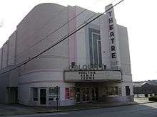
Downtown Moultrie contains the Moultrie Commercial Historic District, listed on the National Register of Historic Places. The district includes the Colquitt Theatre.
Geography
Located in southwest Georgia, Moultrie is in the center of Colquitt County, 24 miles (39 km) west of Interstate 75, and about 200 miles (300 km) south of Atlanta and 60 miles (100 km) northeast of Tallahassee, Florida. The city is located between Albany to the northwest, Tifton to the northeast, Thomasville to the southwest, and Valdosta to the southeast.
According to the United States Census Bureau, the city has a total area of 16.5 square miles (42.8 km2), of which 16.3 square miles (42.3 km2) is land and 0.19 square miles (0.5 km2), or 1.15%, is water.[7]
Moultrie is located at 31°10′13″N 83°47′1″W / 31.17028°N 83.78361°W (31.170188, -83.783601).[8]
History
The city was named after Gen. William Moultrie,[9] the Revolutionary War hero after whom Fort Moultrie was named following the successful defense of Charleston, South Carolina, against the British under Peter Parker, an anniversary subsequently celebrated as Carolina Day.
Colquitt County became the 115th county in Georgia by an act of the Legislature on February 25, 1856. It was named after Walter Terry Colquitt, a minister, statesman and lawyer who was a military leader in the mid-1860s. In 1879, a charter was adopted and 50 acres (0 km2) in the center of the county was declared the county seat.
During the American Civil War, Colquitt County raised several companies of Confederate troops, particularly Company H, 50th Georgia Volunteer Infantry.
Founders of naval stores started harvesting the timbers in the late 1890s. They set up turpentine stills and built tram roads, allowing for the railroad to come into the territory. The Boston & Albany line, which later became the Georgia Northern Railway, was the first through town, bringing with it growth and prosperity for the county. Practically every train brought new residents interested in supplying naval stores or working in the sawmills.
By 1900, through the work of businessmen, bankers and speculators, the county was becoming a farmer's paradise.
Land was cleared and development companies began dividing the forested area into farm tracts. Experienced farmers from north Georgia and the Carolinas were invited to come and develop the land. The county's agriculture industry thrives today.
Moultrie Commercial Historic District
Moultrie Commercial Historic District is a historic area of Moultrie with several buildings of historical significance including the Moultrie Colquitt Towers, formerly a hotel called Hotel Colquitt. The district was listed on the National Register of Historic Places on June 3, 1994. The area is generally bounded by northeast First Avenue, southeast Second Avenue, West First Street and East Fourth Street.
The district's coordinates are: 31°10′48″N 83°47′14″W / 31.18°N 83.787222°W / 31.18; -83.787222
Demographics
| Historical population | |||
|---|---|---|---|
| Census | Pop. | %± | |
| 1900 | 2,221 | — | |
| 1910 | 3,349 | 50.8% | |
| 1920 | 6,789 | 102.7% | |
| 1930 | 8,027 | 18.2% | |
| 1940 | 10,147 | 26.4% | |
| 1950 | 11,639 | 14.7% | |
| 1960 | 15,764 | 35.4% | |
| 1970 | 14,400 | −8.7% | |
| 1980 | 15,105 | 4.9% | |
| 1990 | 14,865 | −1.6% | |
| 2000 | 14,387 | −3.2% | |
| 2010 | 14,268 | −0.8% | |
| Est. 2016 | 14,361 | [2] | 0.7% |
| U.S. Decennial Census[10] | |||
As of the census[3] of 2012, there were 14,506 people, 5,663 households, and 3,505 families residing in the city. The population density was 1,013.0 people per square mile (391.2/km²). There were 6,525 housing units at an average density of 459.4 per square mile (177.4/km²). The racial makeup of the city was 38.05% White, 50.2% African American, 0.33% Native American, 0.37% Asian, 0.05% Pacific Islander, 2.99% from other races, and 0.98% from two or more races. Hispanic or Latino of any race were 10.02% of the population.
There were 5,663 households out of which 31.4% had children under the age of 18 living with them, 34.0% were married couples living together, 23.5% had a female householder with no husband present, and 38.1% were non-families. 33.9% of all households were made up of individuals and 15.8% had someone living alone who was 65 years of age or older. The average household size was 2.43 and the average family size was 3.13.
In the city, the population was spread out with 28.4% under the age of 18, 10.2% from 18 to 24, 25.8% from 25 to 44, 19.7% from 45 to 64, and 16.0% who were 65 years of age or older. The median age was 34 years. For every 100 females, there were 87.2 males. For every 100 females age 18 and over, there were 81.7 males.
The median income for a household in the city was $36,193, and the median income for a family was $43,406. Males had a median income of $27,856 versus $26,417 for females. The per capita income for the city was $40,657. About 16.0% of families and 19.6% of the population were below the poverty line, including 17.8% of those under age 18 and 16.1% of those age 65 or over.
Education
Colquitt County School District
Moultrie public schools are controlled by the Colquitt County Board of Education. The Colquitt County School District holds grades pre-school to grade twelve, consisting of ten elementary schools, a middle school, a junior high school, and one high school.[11] The district has 480 full-time teachers and over 8,342 students.[12]
Elementary schools
- Cox Elementary School
- Doerun Elementary School
- Funston Elementary School
- Hamilton Elementary School
- Norman Park Elementary School
- Odom Elementary School
- Okapilco Elementary School
- Stringfellow Elementary School
- Sunset Elementary School
- Wright Elementary School
- Pre-K Program
Middle schools
Junior high school
High school
Higher education
- Southern Regional Technical College – Main Campus[13]
- Abraham Baldwin Agricultural College – Moultrie Campus[14]
- Philadelphia College of Osteopathic Medicine- South Georgia Campus. Set to open August 2019. Will offer the Doctor of Osteopathic Medicine (DO) degree to 55 initial medical students[15]
Industry
Industry for the Moultrie area grew considerably when Sanderson Farms opened a processing plant in 2006 that now currently employs over 1,000 workers, over 10 percent of the local workforce. The manufacturer of light, single-engined STOL aircraft, the Maule Air, is also located in Moultrie.
Telecommunications
There are two radio and three television stations located in Moultrie.
Transportation
Moultrie is served by US 319, which connects to Interstate 75 and Interstate 10. State Road 37 and State Road 111 also run through Moultrie. Moultrie has two public airports used primarily for general aviation, Moultrie Municipal Airport and Spence Airport.
Historic sites
Moultrie is home to several sites on the National Register of Historic Places listings in Colquitt County, Georgia of the National Register of Historic Places.[16]
Festivals
- Martin Luther King Jr. Day Parade – January
- Automotive Swap Meet – February & November
- Annual Federated Guild Antique Show - March
- The Calico Arts & Crafts Shows – March and November
- Annual Spring Fling & Backyard BBQ – April
- Law Enforcement Memorial Service – May
- Parks & Recreation Fishing Rodeo, 229-890-5429 – June
- Parks & Recreation Annual Community Day, 229-890-5429 – July
- Ram Roundup – July
- Nation Dive Competition – August
- Annual Quilt Exhibition at the Arts Center – August
- National Night Out Community Party at Packer Stadium – August
- Moultrie YMCA Race for the South – September
- Music Under the Magnolias Free Concert on the Downtown Square – October
- 100 Mile Peanut Pickin Yard Sale – October
- Children's Trick-or-Treat on the Downtown Square – October
- Sunbelt Agricultural Exposition – October
- Annual Veterans Wreath Laying Ceremony on the Downtown Square – November
- Lights, Lights Holiday Festival on the Downtown Square – November
- Lighted Christmas Parade around the Downtown Square – December
- Downtown Winter Festival – December
Points of interest
- Museum of Colquitt County History
- Reed Bingham State Park – Enjoy Camping, Hiking, fishing, birding, and boating on the 375 acre lake. You may even spot one of the resident Bald Eagles, alligators or gopher tortoises.
- Ellen Payne Odom Genealogy Library – Search for your foreign roots at our Genealogical Library.
- Spence Field
- Colquitt County Arts Center – The Arts Center is home to permanent collections, theatre groups, concerts, art education, and the Fall Quilt Exhibition.
- Tom White Linear Park, 7.5 mile "Rails to Trails" project, is a must for walkers and cycle enthusiasts.
Climate
The climate in this area is characterized by relatively high temperatures and evenly distributed precipitation throughout the year. According to the Köppen Climate Classification system, Moultrie has a humid subtropical climate, abbreviated "Cfa" on climate maps.[17]
| Climate data for Moultrie, Georgia | |||||||||||||
|---|---|---|---|---|---|---|---|---|---|---|---|---|---|
| Month | Jan | Feb | Mar | Apr | May | Jun | Jul | Aug | Sep | Oct | Nov | Dec | Year |
| Average high °C (°F) | 17 (63) |
20 (68) |
22 (72) |
26 (78) |
30 (86) |
33 (92) |
33 (92) |
33 (92) |
31 (87) |
26 (79) |
21 (69) |
17 (62) |
26 (78) |
| Average low °C (°F) | 6 (43) |
8 (47) |
11 (52) |
14 (57) |
18 (64) |
22 (71) |
22 (72) |
22 (72) |
20 (68) |
14 (57) |
8 (47) |
6 (42) |
14 (58) |
| Average precipitation mm (inches) | 99 (3.9) |
79 (3.1) |
117 (4.6) |
122 (4.8) |
112 (4.4) |
74 (2.9) |
180 (7) |
107 (4.2) |
130 (5.1) |
30 (1.2) |
30 (1.2) |
84 (3.3) |
1,158 (45.6) |
| Source: Weatherbase [18] | |||||||||||||
References
- ↑ "Moultrie history". moultriega.com. Archived from the original on December 7, 2015. Retrieved September 16, 2015.
- 1 2 "Population and Housing Unit Estimates". Retrieved June 9, 2017.
- 1 2 "American FactFinder". United States Census Bureau. Retrieved January 31, 2008.
- ↑ "US Board on Geographic Names". United States Geological Survey. October 25, 2007. Retrieved January 31, 2008.
- ↑ "Find a County". National Association of Counties. Retrieved June 7, 2011.
- ↑ "Profile of General Population and Housing Characteristics: 2010 Demographic Profile Data (DP-1): Moultrie city, Georgia". U.S. Census Bureau, American Factfinder. Retrieved January 31, 2012.
- ↑ "Geographic Identifiers: 2010 Demographic Profile Data (G001): Moultrie city, Georgia". U.S. Census Bureau, American Factfinder. Retrieved January 31, 2012.
- ↑ "US Gazetteer files: 2010, 2000, and 1990". United States Census Bureau. February 12, 2011. Retrieved April 23, 2011.
- ↑ Hellmann, Paul T. (May 13, 2013). Historical Gazetteer of the United States. Routledge. p. 240. Retrieved November 30, 2013.
- ↑ "Census of Population and Housing". Census.gov. Retrieved June 4, 2015.
- ↑ Georgia Board of Education, Retrieved June 4, 2010.
- ↑ School Stats, Retrieved June 4, 2010.
- ↑ Southern Regional Technical College, Retrieved 2015.
- ↑ Abraham Baldwin Agricultural College, Retrieved 2012.
- ↑ PCOM, Retrieved 2018.
- ↑ Colquitt County Historic Buildings
- ↑ Climate Summary for Moultrie, Georgia
- ↑ "Weatherbase.com". Weatherbase. 2013. Retrieved September 28, 2013.
External links
| Wikimedia Commons has media related to Moultrie, Georgia. |
- Official website
- Moultrie-Colquitt County Chamber of Commerce
- Olde Greenfield Church and Historic Cemetery historical marker
Municipalities and communities of Colquitt County, Georgia, United States | ||
|---|---|---|
| Cities | 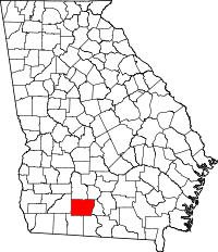 | |
| Towns | ||
| Unincorporated communities | ||
| Footnotes | ‡This populated place also has portions in an adjacent county or counties | |