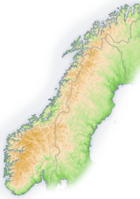
Scandinavian Mountains
| Scandinavian Mountains | |
|---|---|
|
Skanderna, Fjällen, Kjølen, Köli, Skandit | |
 | |
| Highest point | |
| Peak | Galdhøpiggen (Lom) |
| Elevation | 2,469 m (8,100 ft) [1] |
| Coordinates | 61°38′11″N 08°18′45″E / 61.63639°N 8.31250°E |
| Dimensions | |
| Length | 1,700 km (1,100 mi) [2] |
| Width | 320 km (200 mi) [2] |
| Geography | |
 The Scandinavian Mountains
| |
| Countries | Norway, Sweden and Finland |
| Range coordinates | 65°N 14°E / 65°N 14°ECoordinates: 65°N 14°E / 65°N 14°E |
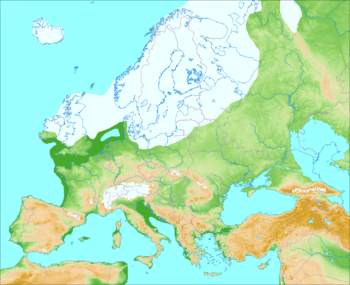
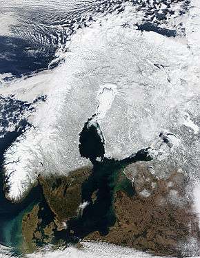
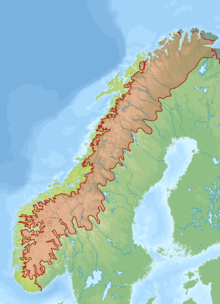
The Scandinavian Mountains or the Scandes is a mountain range that runs through the Scandinavian Peninsula. The Scandinavian Mountains are often erroneously thought to be equivalent to the Scandinavian Caledonides, an ancient mountain range and orogen covering roughly the same area. The western sides of the mountains drop precipitously into the North Sea and Norwegian Sea, forming the fjords of Norway, whereas to the northeast they gradually curve towards Finland. To the north they form the border between Norway and Sweden, still reaching 2,000 metres (6,600 ft) high at the Arctic Circle. The mountain range just touches northwesternmost Finland, but are scarcely more than hills at their northernmost extension at the North Cape (Nordkapp).
The mountains are not very high, but are very steep at places; Galdhøpiggen in South Norway is the highest peak in mainland Northern Europe, at 2,469 metres (8,100 ft), Kebnekaise has the highest peak on the Swedish side, at 2,104 m (6,903 ft), whereas Halti is the highest peak in Finland, at 1,324 m (4,344 ft).
The combination of a northerly location and moisture from the North Atlantic Ocean has caused the formation of many ice fields and glaciers. Temperature drops with increasing altitude; in South Norway, permafrost becomes common from about 1,500 meters above sea level on the western slope, and at about 1,200 meters above sea level on the eastern slope near the border with Sweden. In Northern Norway, permafrost becomes common from around 800 to 900 meters above sea level on the western slope, and some 600 meters above sea level on the eastern slope.[3]
The Scandinavian Montane Birch forest and grasslands terrestrial ecoregion is closely associated with the mountain range.
Names in Scandinavia
Its names in the Scandinavian languages are, in Swedish Skandinaviska fjällkedjan, Skanderna (encyclopaedic and professional usage), Fjällen ("The Fells", common in colloquial speech) or Kölen ("The Keel"), and in Norwegian Den skandinaviske fjellkjede, Skandesfjellene, Kjølen ("The Keel") or Nordryggen ("The North Ridge", name coined in 2013). The names Kölen and Kjølen are often preferentially used for the northern part, where the mountains form a narrow range near the border region of Norway and Sweden. In southern Norway there is a broad scatter of mountain regions with individual names, such as Dovrefjell, Hardangervidda, Jotunheimen, and Rondane.[4][5][6][7]
Orography
The mountain chain's highest summits are mostly concentrated in an area (of mean altitude of over 1,000 m[8]) between Stavanger and Trondheim in southern Norway, with numerous peaks over 1,300 m and some peaks over 2,000 m.[9] Around Trondheim Fjord peaks decrease in altitude to about 400–500 m rising again to heights in excess of 1,900 m further north in Swedish Lapland and nearby areas of Norway.[9][upper-alpha 1] The southern part of the mountain range contains the highest mountain of Northern Europe, Galdhøpiggen at almost 2,500 m.[11] This part of the mountain chain is also broader and contains a series of plateaux and gently undulating surfaces[9][12] that hosts scattered inselbergs.[12] The plateaux and undulating surfaces of the southern Scandinavian Mountains form a series of stepped surfaces. Geomorphologist Karna Lidmar-Bergström and co-workers recognize five widespread stepped surfaces. On eastern Norway some of the stepped surfaces merge into a single surface. Dovre and Jotunheimen are rises from the highest of the stepped surfaces.[13] In south-western Norway the plateaux and gently undulating surfaces are strongly dissected by fjords and valleys.[14] The mountain chain is present in Sweden from northern Dalarna northwards; south of this point the Scandinavian Mountains lie completely within Norway.[9] Most of the Scandinavian Mountains lack "alpine topography",[upper-alpha 2] and where it does have it does not relate to altitude.[12] Example of this is the distribution of cirques in southern Norway that can be found both near sea level and at 2,000 m. Most cirques are found between 1,000 and 1,500 m.[16]
To the east the Scandinavian Mountains proper bounds with mountains that are lower and less dissected and are known in Swedish as the förfjäll (literally "fore-fell"). Generally the förfjäll do not surpass 1,000 m above sea level. As a geomorphic unit the förfjäll extends across Sweden as a 650 km long and 40 to 80 km broad belt from Dalarna in the south to Norrbotten in the north. While lower than the Scandinavian Mountains proper, the förfjäll's pronounced relief, its large number of plateaux and its coherent valley system distinguish it from so-called undulating hilly terrain (Swedish: bergkullsterräng) and plains with residual hills (Swedish: bergkullslätt) found further east.[17]
Geology
Bedrock
Most of the rocks of the Scandinavian Mountains are Caledonian which means they were put in place by the Caledonian orogeny. Caledonian rocks overlie rocks of the much older Svecokarelian and Sveconorwegian provinces. The Caledonian rocks actually form large nappes (Swedish: skollor) that have been thrusted over the older rocks. Much of the Caledonian rocks have been eroded since they were put in place meaning that they were once thicker and more contiguous. It is also implyed from the erosion that the nappes of Caledonian rock reached once further east than they do today. The erosion has left remaining massifs of Caledonian rocks and windows of Precambrian rock.[18]
While there are some disagreements geologists generally recognize four units among the nappes: an Uppermost, an Upper, a Middle and a Lower one. The last one is made up Ediacaran (Vendian), Cambrian, Ordovician and Silurian-aged sedimentary rocks. Pieces of Precambrian shield rocks are in some places also incorporated into the Lower nappes.[18]
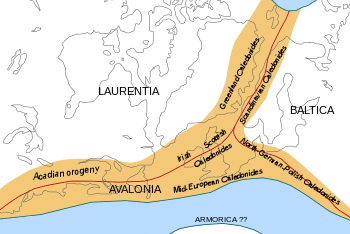
It was during the Silurian and Devonian periods that the Caledonian nappes were stacked upon the older rocks and upon themselves. This occurred in connection to the closure of the Iapetus Ocean as the ancient continents of Laurentia and Baltica collided.[18] This collision produced a Himalayas-sized mountain range named the Caledonian Mountains roughly over the same area as the present-day Scandinavian Mountains.[19][20] In Scandinavia the Caledonian Mountains begun a post-orogenic collapse in the Devonian implying tectonic extension and subsidence.[21] Despite occurring in about the same area the ancient Caledonian Mountains and the modern Scandinavian Mountains are unrelated.[upper-alpha 3]
Origin of the mountains
The origin of today's mountain topography is debated by geologists.[24] Geologically, the Scandinavian Mountains are an elevated, passive continental margin similar to the mountains and plateaux found on the opposite side of the North Atlantic in Eastern Greenland or in Australia's Great Dividing Range.[20] The Scandinavian Mountains attained its height by tectonic processes different from orogeny, chiefly in the Cenozoic.[23] A two-stage model of uplift has been proposed for the Scandinavian Mountains in southern Norway. A first stage in the Mesozoic and a second stage starting from the Oligocene.[19] The uplift of southern Norway has elevated the westernmost extension of the sub-Cambrian peneplain which forms part of what is known as the Paleic surface[upper-alpha 4] in Norway.[26][27] In southern Norway the Scandinavian Mountains had their main uplift phase later (Neogene) than in northern Scandinavia which had its main phase of uplift in the Paleogene.[28] The various episodes of uplift of the Scandinavian Mountains were similar in orientation and tilted landsurfaces to the east while allowing rivers to incise the landscape.[29] Some of the tilted surfaces constitute the Muddus plains landscape of northern Sweden.[28] The progressive tilt contributed also to create the parallel drainage pattern of northern Sweden.[29] Uplift is thought to have been accommodated by coast-parallel normal faults and not by fault-less doming.[29][30] Therefore, the common labelling of the southern Scandivavian Mountains and the northern Scandinavian Mountains as two domes is misleading.[29] The coastal plains of Norway, the strandflat, are likely old surfaces shaped by deep weathering that escaped the uplift that affected the Scandinavian Mountains.[31]
Unlike orogenic mountains there is no widely accepted geophysical model to explain elevated passive continental margins such as the Scandinavian Mountains.[32] Various mechanisms of uplift have, however, been proposed over the years. A 2012 study argues that the Scandinavian Mountains and other elevated passive continental margins most likely share the same mechanism of uplift and that this mechanism is related to far-field stresses in Earth’s lithosphere. The Scandinavian Mountains can according to this view be likened to a giant anticlinal lithospheric fold. Folding could have been caused by horizontal compression acting on a thin to thick crust transition zone (as are all passive margins).[33][34]
Alternative lines of research have stressed the role of climate in inducing erosion that induces an isostatic compensation;[22] fluvial and glacial erosion and incision during the Quaternary is thought to have contributed to the uplift of the mountain by forcing an isostatic response.[22][24] The total amount of uplift produced by this mechanism could be as much as 500 m.[24] Others geoscientists have implied diapirism in the asthenosphere as being the cause of uplift.[22] One hypothesis claim that the early uplift of the Scandinavian Mountains could be indebted to changes in the density of the lithosphere and asthenosphere caused by the Iceland plume when Greenland and Scandinavia rifted apart about 53 million years ago.[35]
Quaternary geology
Many slopes and valleys have straight courses due to the fact that they follow tectonic fractures that are more prone to erosion.[14] Another result of tectonics in the relief is that slopes corresponding to footwalls of normal faults tend to be straight.[12] There is evidence that the drainage divide between the Norwegian Sea and the south-east flowing rivers were once further west.[14] Glacial erosion is thought to have contributed to the shift of the divide, which in some cases ought to have been in excess of 50 km.[14] Much of the Scandinavian Mountains has been sculpted by glacal erosion. The mountain chain is dotted with glacial cirques usually separated from each other by pre-glacial surfaces.[9] Glacier erosion has been limited in these paleosurfaces which form usually plateaus between valleys. As such the paleosurfaces were subject of diverging and slow ice flow during the glaciations. In contrast valleys concentrated ice flow forming fast glaciers or ice streams.[16] At some locations coalesced cirques form arêtes and pyramidal peaks. Glacial reshaping of valleys is more marked in the western part of the mountain chain where drowned glacier-shaped valleys constitute the fjords of Norway. In the eastern part of the mountain chain glacial reshaping of valleys is weaker.[9] Many mountain tops contain blockfields which escaped glacial erosion either by having constituted nunataks in the glacial periods or by being protected from erosion under cold-based glacier ice.[14] Karst systems, with their characteristic caves and sinkholes occur at various locations in the Scandinavian Mountains but are more common in the northern parts. Present-day karst systems might have long histories dating back to the Pleistocene or even earlier times.[14] Much of the mountain range is mantled by deposits of glacial origin including till blankets, moraines, drumlins and glacifluvial material in the form of outwash plains and eskers. Bare rock surfaces are more common in the western side of the mountain range. Although the ages of these deposits and landforms vary, most of them were formed in connection to the Weichselian glaciation and the subsequent deglaciation.[14]
The Cenozoic glaciations that affected Fennoscandia most likely began in the Scandinavian Mountains.[36] It is estimated that during 50% of the last 2.75 million years the Scandinavian Mountains hosted mountain-centered ice caps and ice fields.[37] The ice fields from which the Fennoscandian Ice Sheet grew out multiple times most likely resembled today’s ice fields in Andean Patagonia.[36][upper-alpha 5] During the last glacial maximum (ca. 20 ka BP) all the Scandinavian Mountains was covered by the Fennoscandian Ice Sheet. This ice sheet extended well beyond the mountains into Denmark, Germany, Poland and the former USSR. As the ice margin started to recede 22-17 ka BP the ice sheet became increasingly concentrated in the Scandinavian Mountains. Recession of the ice margin led the ice sheet to be concentrated in two parts of the Scandinavian Mountains, one part in Southern Norway and another in Northern Sweden and Norway. These two centres were for a time linked so that the linkage constituted a major drainage barrier that formed various large ephemeral ice-dammed lakes. About 10,1 ka BP the linkage had disappeared and so did the southern centre of the ice sheet thousand years later. The northern centre remained a few hundred years more and 9,7 ka BP the eastern Sarek Mountains hosted the last remnant of the Fennoscandian Ice Sheet.[38] As the ice sheet retreated to the Scandinavian Mountains it was dissimilar to the early mountain glaciation that gave origin to the ice sheet as the ice divide lagged behind as the ice mass concentrated in the west.[36]
Highest mountains
Norway
Of the 10 highest mountain peaks in Scandinavia (prominence greater than 30 m or 98 ft), six are situated in Oppland, Norway. The other four are situated in Sogn og Fjordane, Norway. There are 83 peaks equal to or taller than 2,200 m (7,218 ft) in Norway.
- 2,469 m (8,100 ft) Galdhøpiggen (Oppland)
- 2,465 m (8,087 ft) Glittertind (Oppland)
- 2,405 m (7,890 ft) Store Skagastølstind (Sogn og Fjordane)
- 2,387 m (7,831 ft) Store Styggedalstinden east (Sogn og Fjordane)
- 2,373 m (7,785 ft) Skarstind (Oppland)
- 2,369 m (7,772 ft) Vesle Galdhøpiggen (Oppland)
- 2,368 m (7,769 ft) Surtningssue (Oppland)
- 2,366 m (7,762 ft) Store Memurutinden (Oppland)
- 2,351 m (7,713 ft) Jervvasstind (Sogn og Fjordane)
- 2,348 m (7,703 ft) Sentraltind (Sogn og Fjordane)
 |
| This article is part of a series on |
| Scandinavia |
|---|
| Geography |
| Viking Age |
| Political entities |
| Former political entities |
| History |
| Other topics |
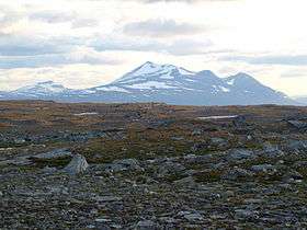
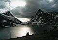
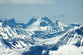 Galdhøpiggen seen from west, Norway's highest mountain
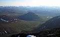 Landscape between Abisko National Park and Kebnekaise
Sweden
There are 12 peaks in Sweden that reach above 2,000 m high (6,600 ft), or 13 depending on how the peaks are defined. This list is defined according to UIAA. Eight of them are located in Sarek National Park and the neighbouring national park Stora Sjöfallet. The other four peaks are located in the further north region of Kebnekaise. All mountain names are in Sami but with the more common Swedish spelling of it.
- 2,104 m (6,903 ft) Kebnekaise (Lappland) - Note: Altitude includes the peak glacier. If melting continues, Kebnekaise Nordtoppen, just 500 meters away, might become the highest point.
- 2,097 m (6,880 ft) Kebnekaise Nordtoppen (Lappland) - the highest fixed point in Sweden.
- 2,089 m (6,854 ft) Sarektjåkkå Stortoppen (Lappland)
- 2,076 m (6,811 ft) Kaskasatjåkka (Lappland)
- 2,056 m (6,745 ft) Sarektjåkkå Nordtoppen (Lappland)
- 2,043 m (6,703 ft) Kaskasapakte (Lappland)
- 2,023 m (6,637 ft) Sarektjåkkå Sydtoppen (Lappland)
- 2,016 m (6,614 ft) Akka Stortoppen (Lappland)
- 2,010 m (6,594 ft) Akka Nordvästtoppen (Lappland)
- 2,010 m (6,594 ft) Sarektjåkkå Buchttoppen (Lappland)
- 2,005 m (6,578 ft) Pårtetjåkka (Lappland)
- 2,002 m (6,568 ft) Palkatjåkka (Lappland)
Other popular mountains for skiers, climbers and hikers in Sweden
- Sulitelma 1,860 m (Lappland)
- Helagsfjället 1,796 m (Härjedalen)
- Norra Storfjället 1,767 m (Lappland)
- Templet 1,728 m (Jämtland)
- Lillsylen 1,704 m (Jämtland)
- Åreskutan 1,420 m (Jämtland)
- Storvätteshågna 1,204 m (Dalarna)
- Molnet 1,191 m (Dalarna)
Finland
- 1,324 m (4,344 ft) Halti (Lappi/Lappland and Norwegian Troms)
- 1,317 m (4,321 ft) Ridnitsohkka (Lappi/Lappland)
- 1,280 m (4,200 ft) Kiedditsohkka (Lappi/Lappland)
- 1,240 m (4,068 ft) Kovddoskaisi (Lappi/Lappland)
- 1,239 m (4,065 ft) Ruvdnaoaivi (Lappi/Lappland)
- 1,180 m (3,871 ft) Loassonibba (Lappi/Lappland)
- 1,150 m (3,773 ft) Urtasvaara (Lappi/Lappland)
- 1,144 m (3,753 ft) Kahperusvaarat (Lappi/Lappland)
- 1,130 m (3,707 ft) Aldorassa (Lappi/Lappland)
- 1,100 m (3,608 ft) Kieddoaivi (Lappi/Lappland)
As of July 2016, to mark the centenary of Finland's independence in 2017, the government of Norway is considering adjusting Norway's border with Finland in the Halti area, giving Finland a 1,331 m peak (one of the two peaks of Halti), which would become Finland's highest point.[39]
The highest independent prominence in Finland is Taivaskero (807 m high) in Pallas-Yllästunturi National Park.
See also
Notes
- ↑ The two high areas, north and south of Trondheim, have been usually referred to as "domes" but technically they are not geological domes.[10]
- ↑ A topography classification study found that 13.6% of the area of southern Norway has a proper "alpine relief", and that this is mostly concentrated in the fjord region of southwestern Norway and the valley of Gudbrandsdalen. About half of the "alpine relief" area is characterized has steep slopes and over-deepened glacial valleys. The other half is made up of coastal mountains and intermediate-relief glacial valleys.[15]
- ↑ The overlap between the Scandinavian Caledonides and the Scandinavian Mountains has led to various suggestions that the modern Scandinavian Mountains are a remnant of the Caledonide mountains.[20][22] A version of this argument was put forward in 2009 with the claim that the uplift of the mountains was attained by buoyancy of the surviving "mountain roots" of the Caledonian orogen.[20] This concept has been criticized since, at present, there is only a tiny "mountain root" beneath the southern Scandinavian Mountains and no "root" at all in the north. Further, the Caledonian Mountains in Scandinavia are known to have undergone orogenic collapse for a long period starting in the Devonian.[20][23][21] Another problem with this model is that it does not explain why other former mountains dating back to the Caledonian orogeny are eroded and buried in sediments and not uplifted by their "roots".[20]
- ↑ After being first described by Hans Reusch in 1901 the Paleic surface was subject of various interpretations in the 20th century.[20][25]
- ↑ These are the Northern Patagonian Ice Field, Southern Patagonian Ice Field and the Gran Campo Nevado.
References
- ↑ "Galdhøpiggen". Nationalencyklopedin (in Swedish). Retrieved 18 July 2010.
- 1 2 Lindström, Maurits. "fjällkedjan". Nationalencyklopedin (in Swedish). Retrieved 18 July 2010.
- ↑ http://www.cicero.uio.no/fulltext/index.aspx?id=9539
- ↑ "- Nordryggen, hæ ?" [The North Ridge, what]. Dagbladet (in Norwegian). 14 September 2013.
- ↑ "Geo365 - Nordryggen: Rotfestet i norsk navnetradisjon". www.geo365.no.
- ↑ TT. "Fjällen får nytt norskt namn - SvD". svd.se.
- ↑ Radio, Sveriges. "Norge namnger fjällen - kallar dem Nordryggen - Nyheter (Ekot)". sverigesradio.se.
- ↑ "The delineation of European mountain areas" (PDF). Mountain Areas in Europe – Final Report. European Commission. p. 27. Retrieved 4 November 2016.
- 1 2 3 4 5 6 Rudberg, Sten (1960). "Geology and Morphology". In Somme, Axel. Geography of Norden. pp. 27–40.
- ↑ Redfield, T.F.; Osmundsen, P.T. (2013). "The long-term topographic response of a continent adjacent to a hyperextended margin: A case study from Scandinavia". GSA Bulletin. 125 (1/2): 184–200. doi:10.1130/B30691.1.
- ↑ Askheim, Svein (14 December 2017). "Den skandinaviske fjellkjede" – via Store norske leksikon.
- 1 2 3 4 Osmundsen, P.T.; Redfield, T.F.; Hendriks, B.H.W.; Bergh, S.; Hansen, J.-A.; Henderson, I.H.C.; Dehls, J.; Lauknes, T.R.; Larsen, Y.; Anda, E.; Davidsen, B. (2010). "Fault-controlled alpine topography in Norway". Journal of the Geological Society, London. 167: 83–98. doi:10.1144/0016-76492009-019.
- ↑ Lidmar-Bergström, Karna; Ollier, C.D.; Sulebak, J.R. (2000). "Landforms and uplift history of southern Norway". Global and Planetary Change. 24: 211–231. doi:10.1016/s0921-8181(00)00009-6.
- 1 2 3 4 5 6 7 Corner, Geoffrey (2004). "Scandes Mountains". In Seppälä, Matti. The Physical Geography of Fennoscandia. Oxford University Press. pp. 240–254. ISBN 0-19-924590-8.
- ↑ Etzelmüller, Bernd; Romstad, Bård; Fjellanger, Jakob (2007). "Automatic regional classification of topography in Norway". Norwegian Journal of Geology. 87: 167–180.
- 1 2 Hall, Adrian M.; Ebert, Karin; Kleman, Johan; Nesje, Atle; Ottesen, Dag (2013). "Selective glacial erosion on the Norwegian passive margin". Geology. 41 (12): 1203–1206. doi:10.1130/g34806.1.
- ↑ Terrängformer i Norden (in Swedish). Nordiska ministerrådet. 1984. p. 10.
- 1 2 3 Lundqvist, Jan; Lundqvist, Thomas; Lindström, Maurits; Calner, Mikael; Sivhed, Ulf (2011). "Fjällen". Sveriges Geologi: Från urtid till nutid (in Swedish) (3rd ed.). Spain: Studentlitteratur. pp. 323–340. ISBN 978-91-44-05847-4.
- 1 2 Gabrielsen, Roy H.; Faleide, Jan Inge; Pascal, Christophe; Braathen, Alvar; Nystuen, Johan Petter; Etzelmuller, Bernd; O'Donnel, Sejal (2010). "Latest Caledonian to Present tectonomorphological development of southern Norway". Marine and Petroleum Geology. 27: 709–723. doi:10.1016/j.marpetgeo.2009.06.004.
- 1 2 3 4 5 6 7 Green, Paul F.; Lidmar-Bergström, Karna; Japsen, Peter; Bonow, Johan M.; Chalmers, James A. (2013). "Stratigraphic landscape analysis, thermochronology and the episodic development of elevated, passive continental margins". Geological Survey of Denmark and Greenland Bulletin. 30: 18. Retrieved 30 April 2015.
- 1 2 Dewey, J.F.; Ryan, P.D.; Andersen, T.B. (1993). "Orogenic uplift and collapse, crustal thickness, fabrics and metamorphic phase changes: the role of eclogites". Geological Society, London, Special Publications. 76 (1): 325–343. doi:10.1144/gsl.sp.1993.076.01.16.
- 1 2 3 4 Schiffer, Christian; Balling, Neils; Ebbing, Jörg; Holm Jacobsen, Bo; Nielsen, Søren Bom (2016). "Geophysical-petrological modelling of the East Greenland Caledonides – Isostatic support from crust and upper mantle". Tectonophysics. 692: 44–57. doi:10.1016/j.tecto.2016.06.023.
- 1 2 Chalmers, J.A.; Green, P.; Japsen, P.; Rasmussen, E.S. (2010). "The Scandinavian mountains have not persisted since the Caledonian orogeny. A comment on Nielsen et al. (2009a)". Journal of Geodynamics. 50: 94–101. doi:10.1016/j.jog.2010.02.001.
- 1 2 3 Medvedev, Sergei; Hartz, Ebbe H. (2015). "Evolution of topography of post-Devonian Scandinavia: Effects and rates of erosion". Geomorphology. 231: 229–245. doi:10.1016/j.geomorph.2014.12.010.
- ↑ Gjessing, Just (1967). "Norway's Paleic Surface". Norsk Geografisk Tidsskrift. 21 (2): 69–132. doi:10.1080/00291956708621854.
- ↑ Lidmar-Bergström, Karna. "Paleiska ytan". Nationalencyklopedin (in Swedish). Cydonia Development. Retrieved June 22, 2015.
- ↑ Jarsve, Erlend M.; Krøgli, Svein Olav; Etzelmüller, Bernd; Gabrielsen, Roy H. (2014). "Automatic identification of topographic surfaces related to the sub-Cambrian peneplain (SCP) in Southern Norway—Surface generation algorithms and implications". Geomorphology. Elsevier. 211: 89–99. doi:10.1016/j.geomorph.2013.12.032.
- 1 2 Lidmar-Bergström, K.; Näslund, J.O. (2002). "Landforms and uplift in Scandinavia". In Doré, A.G.; Cartwright, J.A.; Stoker, M.S.; Turner, J.P.; White, N. Exhumation of the North Atlantic Margin: Timing, Mechanisms and Implications for Petroleum Exploration. Geological Society, London, Special Publications. The Geological Society of London. pp. 103–116.
- 1 2 3 4 Redfied, T.F.; Osmundsen, P.T. (2013). "The long-term topographic response of a continent adjacent to a hyperextended margin: A case study from Scandinavia". GSA Bulletin. 125 (1): 184–200. doi:10.1130/B30691.1.
- ↑ Rohrman, Max; van der Beek, Peter; Andriessen, Paul; Cloetingh, Sierd (1995). "Meso-Cenozoic morphotectonic evolution of southern Norway: Neogene domal uplift inferred from apatite fission track thermochronology". Tectonics. 14 (3): 704–718. Bibcode:1995Tecto..14..704R. doi:10.1029/95tc00088.
- ↑ Klemsdal, Tormod (2005). "Strandflat". In Schwartz, Maurice L. Encyclopedia of Coastal Science. Encyclopedia of Earth Sciences Series. pp. 914–915. ISBN 978-1-4020-3880-8.
- ↑ Bonow, Johan M. (2009). "Atlantens kustberg och högslätter – gamla eller unga?" (PDF). www.geografitorget.se (in Swedish). Geografilärarnas Riksförening.
- ↑ Japsen, Peter; Chalmers, James A.; Green, Paul F.; Bonow, Johan M. (2012). "Elevated, passive continental margins: Not rift shoulders, but expressions of episodic, post-rift burial and exhumation". Global and Planetary Change. 90–91: 73–86. doi:10.1016/j.gloplacha.2011.05.004.
- ↑ Løseth and Hendriksen 2005
- ↑ Nielsen, S.B.; Paulsen, G.E.; Hansen, D.L.; Gemmer, L.; Clausen, O.R.; Jacobsen, B.H.; Balling, N.; Huuse, M.; Gallagher, K. (2002). "Paleocene initiation of Cenozoic uplift in Norway". In Doré, A.G.; Cartwright, J.A.; Stoker, M.S.; Turner, J.P.; White, N. Exhumation of the North Atlantic Margin: Timing, Mechanisms and Implications for Petroleum Exploration. Geological Society, London, Special Publications. The Geological Society of London. pp. 103–116.
- 1 2 3 Fredin, Ola (2002). "Glacial inception and Quaternary mountain glaciations in Fennoscandia". Quaternary International. 95–96: 99–112. doi:10.1016/s1040-6182(02)00031-9.
- ↑ Kleman, J.; Stroeven, A. (1997). "Preglacial surface remnants and Quaternary glacial regimes in northwestern Sweden". Geomorphology. 19: 35–54. doi:10.1016/s0169-555x(96)00046-3.
- ↑ Stroeven, Arjen P.; Hättestrand, Clas; Kleman, Johan; Heyman, Jakob; Fabel, Derek; Fredin, Ola; Goodfellow, Bradley W.; Harbor, Jonathan M.; Jansen, John D.; Olsen, Lars; Caffee, Marc W.; Fink, David; Lundqvist, Jan; Rosqvist, Gunhild C.; Strömberg, Bo; Jansson, Krister N. (2016). "Deglaciation of Fennoscandia". Quaternary Science Reviews. 147: 91–121. doi:10.1016/j.quascirev.2015.09.016.
- ↑ Henley, Jon (28 July 2016). "Norway considers giving mountain to Finland as 100th birthday present". The Guardian. Retrieved 4 November 2016.
External links
![]()