Gates Avenue (BMT Jamaica Line)
Gates Avenue | |||||||||||||
|---|---|---|---|---|---|---|---|---|---|---|---|---|---|
|
| |||||||||||||
 Western exit stair of northbound platform | |||||||||||||
| Station statistics | |||||||||||||
| Address |
Gates Avenue & Broadway Brooklyn, NY 11221 | ||||||||||||
| Borough | Brooklyn | ||||||||||||
| Locale | Bedford-Stuyvesant, Bushwick | ||||||||||||
| Coordinates | 40°41′22″N 73°55′19″W / 40.68949°N 73.922067°WCoordinates: 40°41′22″N 73°55′19″W / 40.68949°N 73.922067°W | ||||||||||||
| Division | B (BMT) | ||||||||||||
| Line |
BMT Jamaica Line BMT Lexington Avenue Line (formerly) | ||||||||||||
| Services |
J Z | ||||||||||||
| Transit connections |
| ||||||||||||
| Structure | Elevated | ||||||||||||
| Platforms | 2 side platforms | ||||||||||||
| Tracks | 3 (2 in regular service) | ||||||||||||
| Other information | |||||||||||||
| Opened | May 13, 1885[1] | ||||||||||||
| Station code | 095[2] | ||||||||||||
| Traffic | |||||||||||||
| Passengers (2017) |
2,262,915[3] | ||||||||||||
| Rank | 219 out of 425 | ||||||||||||
| Station succession | |||||||||||||
| Next east |
Halsey Street: J (Z | ||||||||||||
| Next west |
Kosciuszko Street: J (Z Reid Avenue (Lexington Avenue elevated; demolished) | ||||||||||||
| |||||||||||||
| |||||||||||||
| |||||||||||||


Gates Avenue is a local station on the elevated BMT Jamaica Line of the New York City Subway, located at the intersection of Gates Avenue and Broadway in Bushwick, Brooklyn. It is served by the Z train during rush hours in the peak direction and by the J train at all other times.
History
Gates Avenue is the oldest station in the subway system to have been built as a rapid transit station; it has been serving BMT trains for approximately 133 years. While Far Rockaway – Mott Avenue is the oldest station currently in operation in the New York City Subway system, having originally opened in 1869 as a Long Island Rail Road station, that station had an 8-year disruption in service while being converted to subway loading gauge, meaning that Gates Avenue is the system's oldest station in continuous operation.
Gates Avenue was originally opened by the Union Elevated Railroad on May 13, 1885 for the BMT Lexington Avenue Line, and has been in continuous operation since then. The BMT Jamaica Line connected to the station on June 25, 1888.[4] Prior to the Dual Contracts, trains either operated down Broadway to Broadway Ferry (which closed upon the opening of the Williamsburg Bridge tracks to Essex Street) or Lexington Avenue, eventually merging onto the Myrtle Avenue El.[5] The Dual Contracts expanded the BMT Jamaica Line, including Gates Avenue, to three tracks, allowing for express service, as well as expanding service in Manhattan down Nassau Street. In 1950, the Lexington Avenue El closed, resulting in the redirection of all trains to the Williamsburg Bridge.
Station layout
| P Platform level |
Side platform, doors will open on the right | |
| Westbound local | ← ← | |
| Peak-direction express | → No regular service | |
| Eastbound local | → → | |
| Side platform, doors will open on the right | ||
| M | Mezzanine | Fare control, station agent |
| G | Street Level | Exit/ Entrance |
This station has two side platforms and three tracks with the center express track not normally used. Each platform has beige windscreens and red canopies (both with green frames) that run along the entire length except for a small section at both ends.
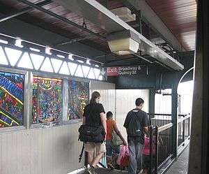
The 2002 artwork here is called Dream Train by Chris Robinson and features mass transit-related stained glass windows in the station house and the windscreens.
South of this station, the BMT Jamaica Line connected to the BMT Lexington Avenue Line before it ceased operation on October 13, 1950 and some remains are visible. The next stop on the Lexington Avenue El was Reid Avenue on its way to Downtown Brooklyn and Park Row, Manhattan.
Exits
Despite the station name, it no longer has an entrance from Gates Avenue. It is now an emergency exit only, containing a single double flight staircase from each platform at their east ends.[6] The station's only entrance is an elevated station house beneath the tracks at Quincy Street and Broadway. It has two street stairs (one leading to the southern corner of the aforementioned intersection and one along the north side of Broadway), a token booth, turnstile bank, and single staircase from each platform at their west end. Both staircase landings have an exit-only turnstile that allow passengers to exit the subway without having to go through the station house.[7]
References
- ↑ "Done at Last". Brooklyn Daily Eagle. Brooklyn, NY. May 13, 1885. p. 1.
- ↑ "Station Developers' Information". Metropolitan Transportation Authority. Retrieved June 13, 2017.
- ↑ "Facts and Figures: Annual Subway Ridership 2012–2017". Metropolitan Transportation Authority. July 12, 2018. Retrieved July 12, 2018.
- ↑ "The Broadway Line Opened". Brooklyn Daily Eagle. Brooklyn, NY. June 25, 1888. p. 6.
- ↑ 1912 BMT service map NYCSubway Retrieved June 1, 2011
- ↑ "Closed subway entrances". WNYC (AM). October 31, 2015. Retrieved July 4, 2016.
- ↑ "MTA Neighborhood Maps: Bushwick" (PDF). mta.info. Metropolitan Transportation Authority. 2015. Retrieved July 20, 2016.
External links
| Wikimedia Commons has media related to Gates Avenue (BMT Jamaica Line). |
- nycsubway.org – BMT Jamaica Line: Gates Avenue
- Station Reporter — J train
- The Subway Nut — Gates Avenue Pictures
- MTA's Arts For Transit — Gates Avenue (BMT Jamaica Line)
- Quincy Street entrance from Google Maps Street View
- Platforms from Google Maps Street View
- Gates Avenue Tower at Broadway Elevated Junction: Lexington Avenue Line (BMT) (New York Transit Museum; Flickr)
| Jamaica Line |
|
|---|---|
| |