Franklin Avenue–Fulton Street (New York City Subway)
Franklin Avenue–Fulton Street | |||||||||||
|---|---|---|---|---|---|---|---|---|---|---|---|
|
| |||||||||||
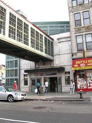 Entrance on south side of Fulton Street | |||||||||||
| Station statistics | |||||||||||
| Address |
Franklin Avenue & Fulton Street Brooklyn, NY 11216 | ||||||||||
| Borough | Brooklyn | ||||||||||
| Locale | Bedford-Stuyvesant | ||||||||||
| Coordinates | 40°40′52″N 73°57′21″W / 40.681126°N 73.955712°WCoordinates: 40°40′52″N 73°57′21″W / 40.681126°N 73.955712°W | ||||||||||
| Division | B (BMT/IND) | ||||||||||
| Line |
BMT Franklin Avenue Line IND Fulton Street Line | ||||||||||
| Services |
A C S | ||||||||||
| Transit connections |
| ||||||||||
| Levels | 2 | ||||||||||
| Other information | |||||||||||
| Opened | October 18, 1999[1] | ||||||||||
| Station code | 627[2] | ||||||||||
| Accessible |
| ||||||||||
| Wireless service |
| ||||||||||
| Traffic | |||||||||||
| Passengers (2017) |
2,058,258 (station complex)[4] | ||||||||||
| Rank | 239 out of 425 | ||||||||||
| |||||||||||
| |||||||||||
| |||||||||||


Franklin Avenue–Fulton Street is a station complex shared by the BMT Franklin Avenue Line and the IND Fulton Street Line of the New York City Subway, located at Franklin Avenue and Fulton Street in Bedford-Stuyvesant, Brooklyn. It is served by the:
- Franklin Avenue Shuttle at all times
- C train at all times except late nights
- A train during late nights
Station layout
| 2F | Side platform, doors will open on the left | |
| Southbound | ← →(Demolished: Dean Street) | |
| 1F | Crossover | to northbound Fulton St. platform |
| G | Street Level | Exit/Entrance |
| B | Northbound platform | Fare control |
| Side platform, doors will open on the right | ||
| Northbound local | ← | |
| Northbound express | ← | |
| Southbound express | → | |
| Southbound local | → | |
| Side platform, doors will open on the right | ||
| Southbound platform | Fare control | |
BMT Franklin Avenue Line platform
Franklin Avenue | |||||||
|---|---|---|---|---|---|---|---|
|
| |||||||
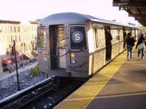 Two-car train of R68s terminating at Franklin Avenue | |||||||
| Station statistics | |||||||
| Division | B (BMT) | ||||||
| Line | BMT Franklin Avenue Line | ||||||
| Services |
S | ||||||
| Structure | Elevated | ||||||
| Platforms | 1 side platform | ||||||
| Tracks | 1 | ||||||
| Other information | |||||||
| Opened | August 15, 1896[5][6] | ||||||
| Rebuilt |
1924 (Dual Contracts) October 18, 1999 (shuttle refurbishment) | ||||||
| Station code | 139[2] | ||||||
| Wireless service |
| ||||||
| Former/other names | Franklin Avenue–Fulton Street | ||||||
| Station succession | |||||||
| Next north |
(Terminal): S | ||||||
| Next south |
Dean Street (demolished): no regular service Park Place: S | ||||||
|
| |||||||
| Next |
none: S | ||||||
| Next |
Park Place: S | ||||||
| |||||||
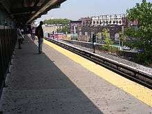
Franklin Avenue on the BMT Franklin Avenue Line (also known as Franklin Avenue–Fulton Street) has one track and one side platform. It is the northern terminal of the Franklin Avenue Shuttle.
History
This elevated station opened on August 15, 1896 to connect with the adjacent Franklin Avenue station of the Fulton Street Elevated. It was a replacement for the August 18, 1878-built Bedford Terminal station originally built by the Brooklyn, Flatbush and Coney Island Railway.[7] It was a two-track through station with side platforms and the point where steam railroad trains from the Fulton Street Line turned onto the BMT Brighton Line to access Brighton Beach. The station also had a connection with the Franklin Avenue Line streetcars.[7]
In 1920, the track connection to the Fulton Street Line was severed as Brighton Line trains to Downtown Brooklyn and Manhattan were rerouted via a new tunnel under Flatbush Avenue. In 1924, the station was rebuilt as a single-track station. The former westbound (now northbound) track was decked over with a wood platform to accommodate crowds transferring between the Fulton Street and Franklin Avenue Lines. The station platforms were also extended south to accommodate longer trains. Originally accommodated for five elevated BU cars for a length of ~250 ft (~76 m), they were now able to hold six subway-type AB Standard cars for a length of ~402 feet (~123 m).
The next stop to the east was Nostrand Avenue for Fulton Street trains and Dean Street for Brighton Line trains. The next stop to the west was Grand Avenue. When the BMT system was taken over by the City of New York on June 1, 1940, the Fulton Street Elevated Line was closed and later demolished while paper transfers were issued at Franklin Avenue for passengers to access the new IND Fulton Street Line subway.
In 1985, the station had only 210 paying daily riders on a typical weekday in 1985 not counting farebeaters, making it one of the least used stations in the system.[8]
Rehabilitation
This station was completely rebuilt between 1998 and 1999[7][9] as a single-track station with a single platform on the west side of the track.[10] The new platform is only 180 feet (55 metres) long and can accommodate a train of two 75 ft (23 m)-long cars, or three 60 ft (18 m)-long cars. The track ends at a bumper block at the north end of the platform.[10]
The 1999 artwork here is called Life and Continued Growth by Eric Pryor. It consists of stained glass panels on the top of the entranceway to the shuttle platform.
Exit
At the north end of the platform is the station's main station house, a three-story building on the southwest corner of Fulton Street and Franklin Avenue that connects to both platforms of Franklin Avenue on the IND Fulton Street Line.[11] One up-only escalator and one long staircase go down to the fare control area at ground level, where one staircase goes down to the southbound IND platform and one turnstile bank provides access to/from the station. A set of doors then lead out to the streets after the token booth.[12]
The shuttle platform has another short staircase that goes down to a glass-enclosed bridge above Fulton Street. On the other end is an elevator and one staircase going down to the northbound IND platform. A second elevator from the shuttle platform goes down to the overpass, main fare control area, and the southbound IND platform. These two elevators make the entire station complex ADA-accessible.[12]
IND Fulton Street Line platforms
Franklin Avenue | |||||||||
|---|---|---|---|---|---|---|---|---|---|
|
| |||||||||
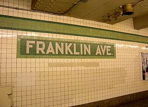 Platform trim line and name tablets | |||||||||
| Station statistics | |||||||||
| Division | B (IND) | ||||||||
| Line | IND Fulton Street Line | ||||||||
| Services |
A C | ||||||||
| Structure | Underground | ||||||||
| Platforms | 2 side platforms | ||||||||
| Tracks | 4 | ||||||||
| Other information | |||||||||
| Opened | April 9, 1936[13] | ||||||||
| Station code | 178[2] | ||||||||
| Accessible |
| ||||||||
| Wireless service |
| ||||||||
| Station succession | |||||||||
| Next north |
Clinton–Washington Avenues: A | ||||||||
| Next south |
Nostrand Avenue: A | ||||||||
|
| |||||||||
| Next |
Jay Street–MetroTech: A | ||||||||
| Next |
Utica Avenue: A | ||||||||
| |||||||||
Franklin Avenue is an underground local station on the IND Fulton Street Line. Opened on April 9, 1936,[13] it has four tracks and two side platforms. The two center express tracks are used by the A train during daytime hours.[10]
Both platforms have a lime green trim line on a dark green border with small "FRANKLIN" signs below them in white lettering on a black border. The name tablets read "FRANKLIN AVE." in white sans serif font on dark green background and lime green border. Directional signs are underneath them and there is evidence of a former fare control area on the west (railroad north) end of the station, which went to Classon Avenue.[14] These exits were closed in the 1980s.[14]
Prior to introduction of the MetroCard, the Euclid Avenue-bound platform had a same-level fare control and a paper bus-style transfer was handed out at either IND fare control areas (the only place in the subway where this was still being done) for access to the shuttle station only. After the MetroCard was introduced, a paper MetroCard transfer was issued from a machine that resembled a bus farebox. These transfers were good for twenty minutes and were discontinued after construction of the in-system transfer.
Exits
Fare control areas are at the extreme east (railroad south) end of the platforms. On the Manhattan-bound side, there is an unstaffed turnstile bank and one staircase going up to the northeast corner of Franklin Avenue and Fulton Street. Inside fare control, one staircase and one elevator go up to the overpass above Fulton Street that connects to the shuttle platform. On the Euclid Avenue-bound platform, a staircase goes up to the main station house, where a connection to the Franklin Avenue Shuttle is available.[11] An elevator from the platform goes up to the shuttle platform with intermediate stops at the main station house and overpass.[12]
BMT Fulton Street Line platform
Franklin Avenue | |||||||||||||||||||||||||||||
|---|---|---|---|---|---|---|---|---|---|---|---|---|---|---|---|---|---|---|---|---|---|---|---|---|---|---|---|---|---|
| Former New York City Subway station | |||||||||||||||||||||||||||||
| Station statistics | |||||||||||||||||||||||||||||
| Division | B (BMT) | ||||||||||||||||||||||||||||
| Line | BMT Fulton Street Line (formerly) | ||||||||||||||||||||||||||||
| Services | None | ||||||||||||||||||||||||||||
| Structure | Elevated | ||||||||||||||||||||||||||||
| Other information | |||||||||||||||||||||||||||||
| Opened | April 24, 1888 | ||||||||||||||||||||||||||||
| Station succession | |||||||||||||||||||||||||||||
| Next west | Grand Avenue | ||||||||||||||||||||||||||||
| Next east | Nostrand Avenue | ||||||||||||||||||||||||||||
| |||||||||||||||||||||||||||||
References
- ↑ Thomas J. Lueck, New York Times, Subway Shuttle Gets $74 Million Makeover, October 18, 1999, page B3
- 1 2 3 "Station Developers' Information". Metropolitan Transportation Authority. Retrieved June 13, 2017.
- 1 2 3 "NYC Subway Wireless – Active Stations". Transit Wireless Wifi. Retrieved May 18, 2016.
- ↑ "Facts and Figures: Annual Subway Ridership 2012–2017". Metropolitan Transportation Authority. July 12, 2018. Retrieved July 12, 2018.
- ↑ "New Route to Coney Island". Brooklyn Daily Eagle. Brooklyn, NY. August 14, 1896. p. 12.
- ↑ "First Trains to Brighton". Brooklyn Daily Eagle. Brooklyn, NY. August 14, 1896. p. 7.
- 1 2 3 "The lore of the FRANKLIN AVENUE SHUTTLE - Forgotten New York". forgotten-ny.com. Retrieved July 21, 2016.
- ↑ Levine, Richard (November 5, 1986). "COLUMN ONE: TRANSPORT". The New York Times. ISSN 0362-4331. Retrieved October 2, 2016.
- ↑ Blair, Jayson (July 25, 1998). "18-Month Renovation for Brooklyn Shuttle". The New York Times. ISSN 0362-4331. Retrieved July 21, 2016.
- 1 2 3 Dougherty, Peter (2006) [2002]. Tracks of the New York City Subway 2006 (3rd ed.). Dougherty. OCLC 49777633 – via Google Books.
- 1 2 "MTA Neighborhood Maps: Bedford-Stuyvesant" (PDF). Metropolitan Transportation Authority. 2016. Retrieved July 5, 2016.
- 1 2 3 "Accessible Stations in the MTA Network". web.mta.info. Metropolitan Transportation Authority. Retrieved November 29, 2016.
- 1 2 "NEW SUBWAY LINK OPENED BY MAYOR; He Tells 15,000 in Brooklyn It Will Be Extended to Queens When Red Tape Is Cut". The New York Times. April 9, 1936. ISSN 0362-4331. Retrieved August 15, 2016.
- 1 2 "Review of the A and C Lines" (PDF). Metropolitan Transportation Authority. December 11, 2015. Retrieved January 19, 2016.
External links
| Wikimedia Commons has media related to Franklin Avenue – Fulton Street (New York City Subway). |
- nycsubway.org – BMT Franklin: Franklin Avenue
- nycsubway.org – IND Fulton: Franklin Avenue
- nycsubway.org — Life and Continued Growth Artwork by Eric Pryor (1999)
- Station Reporter — C Train
- Station Reporter — Franklin Shuttle
- Station Reporter — Fulton Elevated
- The Subway Nut - Franklin Avenue Pictures
- MTA's Arts For Transit — Franklin Avenue
- Franklin Avenue entrance to Manhattan bound Fulton Street Line from Google Maps Street View
- Franklin Avenue entrance to Rockaway bound Fulton Street Line and Shuttle from Google Maps Street View
- BMT platform from Google Maps Street View
- IND platforms from Google Maps Street View
| Fulton St. Line |
|
|---|---|
| Franklin Ave. Line | |
| |