Fréjus
| Fréjus | |||
|---|---|---|---|
| Commune | |||
 | |||
| |||
 Fréjus Location within Provence-A.-C.d'A. region  Fréjus | |||
| Coordinates: 43°25′59″N 6°44′13″E / 43.4330°N 6.737°ECoordinates: 43°25′59″N 6°44′13″E / 43.4330°N 6.737°E | |||
| Country | France | ||
| Region | Provence-Alpes-Côte d'Azur | ||
| Department | Var | ||
| Arrondissement | Draguignan | ||
| Canton | Fréjus and Saint-Raphaël | ||
| Intercommunality | Var Estérel Méditerranée | ||
| Government | |||
| • Mayor (2014–2020) | David Rachline (RN) | ||
| Area1 | 102.27 km2 (39.49 sq mi) | ||
| Population (2006)2 | 52,389 | ||
| • Density | 510/km2 (1,300/sq mi) | ||
| Time zone | UTC+1 (CET) | ||
| • Summer (DST) | UTC+2 (CEST) | ||
| INSEE/Postal code | 83061 /83600 | ||
| Elevation |
0–616 m (0–2,021 ft) (avg. 8 m or 26 ft) | ||
|
1 French Land Register data, which excludes lakes, ponds, glaciers > 1 km2 (0.386 sq mi or 247 acres) and river estuaries. 2 Population without double counting: residents of multiple communes (e.g., students and military personnel) only counted once. | |||

.svg.png)
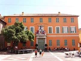
Fréjus (Occitan: Frejús, French pronunciation: [fʁe.ʒys]) is a commune in the Var department in the Provence-Alpes-Côte d'Azur region in southeastern France.
It neighbours Saint-Raphaël, effectively forming one town. The north of the commune forms part of the Estérel Massif.
On 2 December 1959, the Malpasset Dam, on the Reyran River above Fréjus, ruptured, killing over 400 people.
History of Fréjus
The origins of Frejus probably lie with the Celto-Ligurian people who settled around the natural harbour of Aegytna. The remains of a defensive wall are still visible on Mont Auriasque and Cap Capelin. The Phocaeans of Marseille later established an outpost on the site.
Foundation
Frejus was strategically situated at an important crossroads formed by the Via Julia Augusta (which ran between Italy and the Rhône) and the via Domitiana. Although there are only few traces of a settlement at that time, it is known that the famous poet Cornelius Gallus was born there in 67 BC.[1]
Julius Caesar wanted to supplant Massalia and he founded the city as 'Forum Julii' meaning 'market of Julius'; he also named its port 'Claustra Maris' (the sea barrier).
The exact date of the founding of Forum Julii is uncertain, but it was certainly before 43 BC since it appears in the correspondence between Plancus and Cicero and 49 BC is most likely.
Roman city
It was at Forum Julii that Octavius repatriated the galleys taken from Mark Antony at the Battle of Actium in 31 BCE.[2] and between 29 and 27 BCE, Forum Julii became a colony for his veterans of the eighth legion, adding the suffix Octavanorum Colonia.[3]
Augustus made the city the capital of the new province of Narbonensis in 22 BCE, spurring rapid development. It became one of the most important ports in the Mediterranean; its port was the only naval base for the Roman fleet of Gaul and only the second port after Ostia until at least the time of Nero.[4]
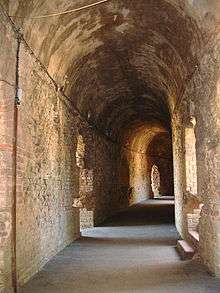
Subsequently, under Tiberius, the major monuments and amenities still visible today were constructed: the amphitheatre, the aqueduct, the lighthouse, the baths and the theatre. Forum Julii had impressive walls of 3.7 km length that protected an area of 35 hectares. There were about six thousand inhabitants. The territory of the city, the civitas forojuliensis, extended from Cabasse in the west to Fayence and Mons in the north.
It became an important market town for craft and agricultural production. Agriculture developed with villa rusticas such as at Villepey[5] and St. Raphael. Mining of green sandstone and blue porphyry and fish farming contributed to the thriving economy.
In 40 CE Gnaeus Julius Agricola, who later completed the Roman conquest of Britain, was born in Forum Julii. He was father-in-law of the historian Tacitus, whose biography of Agricola mentions that Forum Julii was an "ancient and illustrious colony".[6] The city was also mentioned several times in the writings of Strabo and Pliny the Elder.
In early 69 the Battle of Forum Julii was fought between the armies of the rival emperors Otho and Vitellius.[7] The exact location of this battle is not known, but afterwards Vitellius retreated to Antipolis.
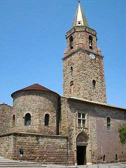
The 4th century saw the creation of the diocese of Fréjus, France's second largest after that of Lyon; the building of the first church is attested in 374 with the election of a bishop. Saint-Léonce became Bishop of Fréjus in 433 and wrote: "From 374, at the Council of Valencia, a bishop was appointed in Frejus, but he never came. I was the first of the bishops of that city. I was able to build the first Cathedral with its Baptistery."
The decay of Rome led to that of the cities of its empire.
Monuments
The richest architectural era is undoubtedly that of the Roman city with many buildings making it the richest concentration in France after Arles. The most notable are:
- The amphitheatre
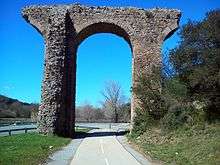
- The aqueduct
- the theatre.
In addition the old town is home to many other impressive remains: the walls, the three gates (of Rome, of Reyran, and d'Orée), the square of Agricola with the gate of the Gauls, an exedra and the platform with a cistern and baths on the Butte Saint-Antoine, the paving of the via Aurelia which passed through the city, the remains of the harbour ancient, with the remains of the north quay and the lighthouse and quay of Augustus, a mosaic floor of fighting cocks in a private property, and the sewers under the present rue Jean Jaures.
A probable military or naval camp was excavated at Villeneuve [8](Goudineau 1982) near the ancient shore line and the Roman baths (probably military)[9] parts of which are incorporated in modern buildings and also rather isolated to the south-west of the ancient city.
Nearby in the territory, there is also a 4th-century mausoleum at rue de La Tourrache in the Villeneuve suburb, the remains of a suburban villa at La Rose des Sables, Roman road bridges at Cantonniers and at Esclapes (with three arches), a fulling mill at Arsenal, remains in Villepey, a necropolis in Sainte-Brigitte and fishponds on the coast at Saint-Aygulf.
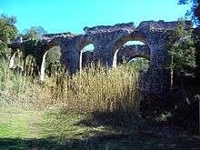
Aqueduct
The aqueduct is 42 km long and runs for 1.8 km on bridges and 500m on walls. Large parts of the aqueduct are still well preserved.[10]
Roman port
An archaeological campaign in July 2005[11] revealed a portion of ancient rocky coast which showed it was almost one kilometre further inland than current estimates. In the middle of the 1st century A.D. at the time of the creation of Forum Iulii, this coastline was a narrow band of approximately 100m wide at the south of the Butte Saint-Antoine. Further recent archaeology has revealed much information on the ancient port.[12] A Triton monument was discovered at the entrance to the harbour. This statue and the remains of a Roman building at the end of the eastern quay nearby, shows this site to be a lighthouse. Two lighthouses were constructed on the quays and a third assisted mariners in locating the harbour’s sea entrance. The third, situated on the Île du Lion de Mer, would have been the primary beacon that ships would have navigated toward. As ships approached the harbour, the Triton lighthouse on the northern side of the channel into the harbour and the other lighthouse on the southern side would have marked the entrance and thus provided safe passage into the harbour.
Post-Roman history
Between the 7th and the 9th centuries, Muslim invaders repeatedly raided the city. The sea encroached on the land while invasions by the Muslims and pirates left the monuments in ruin. By the 10th century there was very little left of the colony, mostly rubble. Sea-borne silt clogged up the port and led to the formation of a huge swampy plain, which then separated the village from the sea.
Napoleon Bonaparte landed at Frejus on 9 October 1799, returning from Egypt in order to ostensibly defend the French Directory in Paris.
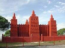
During the First World War Fréjus became the main centre for hivernage (wintering) for the Senegalese Tirailleurs. The town also contained segregated hospitals with images of African village life painted on the walls[13]
List of mayors
| Start | End | Name | Party | |
|---|---|---|---|---|
| 1977 | 1997 | François Léotard | UDF–PR | |
| 1997 | 2014 | Élie Brun | UMP | |
| 2014 | - | David Rachline | FN | |
Notable people
- Gnaeus Julius Agricola, Roman governor of the province of Britain
- St. Maximus, Abbot at Lerins and Bishop of Frejus (d. 460)
- Belinda Carlisle, singer, lives in Fréjus
- Kévin Constant, footballer
- Mario Espartero, footballer
- Odiah Sidibe, athlete
- Abbé Sieyès, French Revolution theorist and author of What is the Third Estate?, was born in Fréjus in 1748
- Mickael Abbate, director and producer, was born in Fréjus in 1983
- Marc Andreu, rugby union player
- Anthony Modeste, footballer
- Adil Rami, footballer
- Layvin Kurzawa, footballer
Other sights
Fréjus organises several fairs throughout the year, and there is the pottery fair and the Bravade amongst its Roman and Gothic architecture with the 'old tile' roof tops and tinted walls. Everything blends in happily with the recently developed port and its neo palladian design and carefully selected Provençal colours . Port Fréjus which has a capacity of 750 moorings, is surrounded by beautiful fine sandy beaches. As a backdrop there is the massif de l'Esterel, the (Esterel hills) and its 'Nature' base situated on the sea edge, as well as protecting the area and its environment. Many sporting events are held here. There's the annual 'Roc Azur' mountain bike event.
Transport
The Gare de Fréjus railway station offers connections to Toulon, Nice and several regional destinations. Long distance destinations are accessible from the nearby Gare de Saint-Raphaël-Valescure. The A8 motorway connects Fréjus with Aix-en-Provence and Nice.
Climate
| Climate data for Fréjus (1981–2010 averages, extremes 1919–present) | |||||||||||||
|---|---|---|---|---|---|---|---|---|---|---|---|---|---|
| Month | Jan | Feb | Mar | Apr | May | Jun | Jul | Aug | Sep | Oct | Nov | Dec | Year |
| Record high °C (°F) | 22.8 (73) |
23.0 (73.4) |
27.3 (81.1) |
28.3 (82.9) |
32.6 (90.7) |
37.7 (99.9) |
42.5 (108.5) |
41.5 (106.7) |
35.0 (95) |
35.9 (96.6) |
26.6 (79.9) |
23.2 (73.8) |
42.5 (108.5) |
| Average high °C (°F) | 13.1 (55.6) |
13.8 (56.8) |
16.1 (61) |
18.0 (64.4) |
22.0 (71.6) |
25.7 (78.3) |
28.8 (83.8) |
28.9 (84) |
25.5 (77.9) |
21.3 (70.3) |
16.7 (62.1) |
13.5 (56.3) |
20.3 (68.5) |
| Daily mean °C (°F) | 8.2 (46.8) |
8.6 (47.5) |
10.8 (51.4) |
13.0 (55.4) |
17.0 (62.6) |
20.6 (69.1) |
23.3 (73.9) |
23.4 (74.1) |
20.2 (68.4) |
16.6 (61.9) |
12.0 (53.6) |
8.9 (48) |
15.3 (59.5) |
| Average low °C (°F) | 3.3 (37.9) |
3.4 (38.1) |
5.6 (42.1) |
8.0 (46.4) |
11.9 (53.4) |
15.4 (59.7) |
17.9 (64.2) |
18.0 (64.4) |
14.8 (58.6) |
11.8 (53.2) |
7.3 (45.1) |
4.3 (39.7) |
10.2 (50.4) |
| Record low °C (°F) | −9.0 (15.8) |
−12.0 (10.4) |
−8.6 (16.5) |
−1.8 (28.8) |
1.1 (34) |
5.5 (41.9) |
7.5 (45.5) |
7.7 (45.9) |
4.5 (40.1) |
0.1 (32.2) |
−3.3 (26.1) |
−7.0 (19.4) |
−12.0 (10.4) |
| Average precipitation mm (inches) | 70.6 (2.78) |
41.6 (1.638) |
45.0 (1.772) |
73.9 (2.909) |
45.7 (1.799) |
33.2 (1.307) |
13.1 (0.516) |
35.8 (1.409) |
74.7 (2.941) |
119.5 (4.705) |
99.7 (3.925) |
94.5 (3.72) |
747.3 (29.421) |
| Average precipitation days (≥ 1.0 mm) | 5.9 | 4.8 | 4.9 | 7.2 | 5.0 | 3.6 | 1.4 | 2.4 | 4.8 | 7.4 | 7.3 | 6.5 | 61.2 |
| Average snowy days | 0.7 | 0.4 | 0.1 | 0.0 | 0.0 | 0.0 | 0.0 | 0.0 | 0.0 | 0.0 | 0.1 | 0.2 | 1.5 |
| Average relative humidity (%) | 75 | 73 | 72 | 73 | 76 | 75 | 73 | 74 | 77 | 78 | 77 | 76 | 74.9 |
| Mean monthly sunshine hours | 155.9 | 166.6 | 217.7 | 220.7 | 264.9 | 311.1 | 346.1 | 313.4 | 234.2 | 171.9 | 141.6 | 121.2 | 2,665.2 |
| Source #1: Meteo France[14] | |||||||||||||
| Source #2: Infoclimat.fr (humidity and snowy days 1961–1990)[15] | |||||||||||||
Twin towns - sister cities
Fréjus is twinned with:


See also
References
- ↑ The Origin of Cornelius Gallus; Ronald Syme; The Classical Quarterly Vol. 32, No. 1
- ↑ Tacitus Annals IV, 5
- ↑ Pliny the Elder, Histories, III, 35
- ↑ Tacitus Histories 2, 14; 3, 43
- ↑ Donnadieu A. 1930 : « Les fouilles des ruines gallo-romaines de Villepey (Villa Podii). Près Fréjus (Forum Julii) », Institut des fouilles de Provence et des préalpes. Bulletin et Mémoires, 1926-1928,
- ↑ Tacitus Histories 3, 43
- ↑ Tacitus: Histories 2.14-15.
- ↑ Une fouille récente à la périphérie de Forum Julii: le chantier des Aiguières [article] Goudineau, Christiansem; Comptes rendus des séances de l'Académie des Inscriptions et Belles-Lettres Année 1982 Volume 126
- ↑ A Donnadieu; Le port militaire de Forum Julii, Paris 1935
- ↑ http://www.romanaqueducts.info/aquasite/frejus/index.html
- ↑ New data on the ancient littoral of Fréjus. The archaeological evaluation of the "théâtre d’agglomération" (Fréjus, Var); Pierre Excoffon, Benoît Devillers, Stéphane Bonnet et Laurent Bouby; http://archeosciences.revues.org/59
- ↑ Fréjus (Forum Julii): Le Port Antique / The Ancient Harbour by Chérine Gébara and Christophe Morhange, ISBN 978-1-887829-77-9
- ↑ Mann, Gregory (April 2005). "Locating Colonial Histories: Between France and West Africa". The American History Journal. 110 (5): 409–434.
- ↑ "Frejus (83)" (PDF). Fiche Climatologique: Statistiques 1981–2010 et records (in French). Meteo France. Archived from the original (PDF) on 5 April 2018. Retrieved 5 April 2018.
- ↑ "Normes et records 1961-1990: Fréjus - St Raphaël (83) - altitude 2m" (in French). Infoclimat. Archived from the original on 6 March 2016. Retrieved 5 April 2018.
External links
| Wikimedia Commons has media related to Fréjus. |

- Official website (in French)
- Frejus website
- Forum Julii in 3D
- Fréjus la plate-forme
- Tourism website (in French)
- Port of Frejus Marina
- Photo of Fréjus Cathedral