Draguignan
| Draguignan | ||
|---|---|---|
| Subprefecture and commune | ||
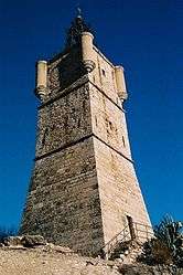 Clock tower of Draguignan. | ||
| ||
 Draguignan Location within Provence-A.-C.d'A. region  Draguignan | ||
| Coordinates: 43°32′25″N 6°28′00″E / 43.5403°N 6.4667°ECoordinates: 43°32′25″N 6°28′00″E / 43.5403°N 6.4667°E | ||
| Country | France | |
| Region | Provence-Alpes-Côte d'Azur | |
| Department | Var | |
| Arrondissement | Draguignan | |
| Canton | Draguignan | |
| Intercommunality | Draguignan | |
| Government | ||
| • Mayor (2014-2020) | Richard Strambio | |
| Area1 | 53.7 km2 (20.7 sq mi) | |
| Population (2006)2 | 38,258 | |
| • Density | 710/km2 (1,800/sq mi) | |
| Demonym(s) | Dracénois | |
| Time zone | UTC+1 (CET) | |
| • Summer (DST) | UTC+2 (CEST) | |
| INSEE/Postal code | 83050 /83300 | |
| Elevation |
153–603 m (502–1,978 ft) (avg. 181 m or 594 ft) | |
|
1 French Land Register data, which excludes lakes, ponds, glaciers > 1 km2 (0.386 sq mi or 247 acres) and river estuaries. 2 Population without double counting: residents of multiple communes (e.g., students and military personnel) only counted once. | ||

Draguignan (French pronunciation: [dʁa.ɡi.ɲɑ̃]; Occitan: Draguinhan) is a commune in the Var department in the Provence-Alpes-Côte d'Azur region, in southeastern France.
It is a sub-prefecture of the department and self-proclaimed "capital of Artillery" and "Porte du Verdon".
The city is 42 km (26 mi) from St. Tropez, and 80 km (50 mi) from Nice.
City's name
According to legend, the name of the city is derived from the Latin name "Draco/Draconem" (dragon): a bishop, called Saint Hermentaire, killed a dragon and saved people.
Motto
The Latin motto of Draguignan is Alios nutrio, meos devoro (I nourish others, I devour my own).
Geography
The elevation is 200 m. The highest hill near Draguignan is Malmont (551 m). The main river near Draguignan is the Nartuby.
The city is set in a valley NW-SE, about 2 km (1 mi) wide.
Climate
Draguignan's climate is the same as the normal conditions of the Mediterranean climate. The nights of frost are rare and the negative temperatures occur only a few days a year. Thus the winters are mild and wet, and the summers warm and dry, the town is protected from the winds by the Malmont and the western massif of the Selves. During the summer the precipitation is extremely low whereas autumn is subjected to frequent rains.
| Sunlight (h/year) | Rain (d/year) | Snow (d/year) | Thunderstorm (d/year) | Fog (d/year) | |
|---|---|---|---|---|---|
| Average (France) | 1 973 | 770 | 14 | 22 | 40 |
| Draguignan | 2714 | 734 | 1 | 29 | 1 |
source= Météo France
Geology
The hills downstream of Draguignan date from the Middle Triassic, while those that rise upstream belong to the Upper Triassic.
Up North, we can see a long bar of stony plateau, with summits made of Jurassic limestones, sometimes intersected by deep canyons. This northern region of the "baous" or also called massive mountainous barriers, deeply wrinkled and fractured, reveals successive basins in the east-west direction.
Communication routes
Roads
There is no highway going through the city of Draguignan but the town is directly connected by the D 1555 to a major highway, the A8.
A bypass route makes it possible to avoid the city center from the south when arriving from Trans-en-Provence and to get to the hospital in the north of the city more quickly.
The city is located 869 km away from Paris, 141 km from Marseille, 89 km from Nice, 86 km from Toulon, 30 km from Fréjus, 105 km from Digne-les-Bains and about 35 km from the Gulf of Saint-Tropez.
Rail transports
The closest railway station is les Arcs-Draguignan, which is served by the TGV and is located twelve kilometers from the city center. Bus shuttles have been set by the agglomeration community of Draguignan railway station. Now it has been converted into a classic bus station. Draguignan train station features two turnstiles: one for SNCF and another for the transport of the agglomeration.
.JPG)
Public transport services
Urban transports are managed by the TED community, which offers three urban lines as well as lines to other municipalities such as Les Arcs-Draguignan, Ampus, Flayosc, Le Muy and Lorgues.The buses of the General Council of the Var serve from Draguignan the cities of Toulon, Brignoles, Aups, Fayence, Fréjus and Le Luc.
A project by BHNS is being studied, to connect Draguignan city center to Les Arcs-Draguignan station in 17 minutes instead of 25 minutes currently.
Seismicity
There are three zones of seismicities in the Var:
Area 0: Negligible risk. This is the case for many municipalities on the Var coast, as well as part of the communes of the Var center. Nevertheless, these communes are not immune from a tsunami effect, linked to an earthquake at sea.
Area Ia: Very low risk. It mainly concerns the municipalities included in a strip from the Montagne Sainte-Victoire to the Massif de l'Esterel.
Area Ib: Low risk. This highest risk of the department, concerns 21 communes in the north of the department.
The commune of Draguignan, is in the seismic zone of very low risk "Ia3".
History
- The name of Draguignan ("Dragonianum") appeared for the first time in 909.
- During the Middle-Ages, Draguignan was a small village whose people lived from olive and grape cultivation.
- Draguignan became the "prefecture" of the Var in 1790, at the beginning of the French Revolution. This was despite the town by far not being the biggest city in the department. It remained the seat of the prefecture until 1974.
- In the 19th century and during a large part of the 20th century, the people of Draguignan (in French: "Dracénois", in English: "Draceners") voted for liberal parties (Radical-Socialist Party, Socialist Party).
- The town was occupied by the Wehrmacht in 1942-44 and freed in August 1944, after Operation Dragoon.
- The city welcomed the "Ecole nationale d'artillerie" (Artillery School) in 1976, then the "Ecole nationale d'infanterie" (Infantry School) in 2010. The arrival of the military involved the development of the city : the small town became a city in the second part of the 20th century : 13 400 citizens in 1954, 33 000 in 2000, 38 000 in 2010.
- On June 15, 2010, the city was flooded. Torrential rain caused the deaths of 12 people in the town and 25 in the neighborhoods.
Major attractions
- Museum of Artillery (Napoleonic wars, World War I, World War II, Indochina, etc.)
- Museum of "Arts et traditions populaires"
- Rhone American Cemetery and Memorial (American World War II cemetery) (see operation Dragoon)
- The Eglise St Michel
- Eglise Notre-Dame du Peuple
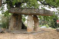
- The Dolmen Pierre de la fée (fairy's Stone), also known as the fruit rock.
Personalities connected to Draguignan
- Georges Clemenceau, was a politician of Draguignan : deputy of the district of Draguignan (1885–1893) and senator of the same district (1902–1920), French prime minister in 1906-1909 and 1917–1920
- Émile Ollivier, was a politician of Draguignan : deputy of the district of Draguignan, then prime minister in 1870
- Maximin Isnard, was a politician of Draguignan
- Georges Thill, died in Draguignan
- Lily Pons, born in Draguignan
- Claude Gay, born in Draguignan
- Abel Douay, born in Draguignan
- Hippolyte Mège-Mouriès, born in Draguignan
- Alain Connes, born in Draguignan
- Ivan Pavlak, born in Draguignan
- Michaël Fabre, born in Draguignan
- Nicolas Agnesi, born in Draguignan
- Charlotte Morel, born in Draguignan
- Michel Constantin, died in Draguignan
- Jean-Marie Auberson, died in Draguignan
- Louis Moréri, studied in Draguignan
- Gustave Ferrié, studied in Draguignan
- Philippe Seguin, studied in Draguignan
- Michel Lafourcade, died in Draguignan
- Ronald Searle, British artist, died in Draguignan
- Henri Mulet, French organist and composer, spent the last 30 years of his life in Draguignan, as organist of the cathedral there.
- Karl Amoussou Karl "Psycho" Amoussou is a MMA fighter in Bellator Fighting Championships. born in Draguignan.
Twin towns
Pictures
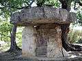 The Dolmen Pierre de la fée.
 The Town Theatre of Draguignan (Théatre Municipal).
 The old Railway Station, which is still called Gare SNCF even though the tracks from Les Arcs to Draguignan were dismantled or closed down.
 Organ in the church of Saint Michael
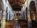 The church of Saint Michael
 Art pieces on the street in Draguignan
 Draguignan In the old city
See also
References
External links
| Wikimedia Commons has media related to Draguignan. |
- City council website (in French)