Le Muy
| Le Muy | ||
|---|---|---|
| Commune | ||
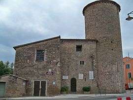 The Tower of Charles Quint, which is an historic monument and contains the Liberation Museum | ||
| ||
 Le Muy Location within Provence-A.-C.d'A. region  Le Muy | ||
| Coordinates: 43°28′25″N 6°34′00″E / 43.4736°N 6.5667°ECoordinates: 43°28′25″N 6°34′00″E / 43.4736°N 6.5667°E | ||
| Country | France | |
| Region | Provence-Alpes-Côte d'Azur | |
| Department | Var | |
| Arrondissement | Draguignan | |
| Canton | Vidauban | |
| Intercommunality | Draguignan | |
| Government | ||
| • Mayor (2008–2014) | Liliane Boyer | |
| Area1 | 66.58 km2 (25.71 sq mi) | |
| Population (2006)2 | 8,743 | |
| • Density | 130/km2 (340/sq mi) | |
| Time zone | UTC+1 (CET) | |
| • Summer (DST) | UTC+2 (CEST) | |
| INSEE/Postal code | 83086 /83490 | |
| Elevation |
7–561 m (23–1,841 ft) (avg. 30 m or 98 ft) | |
|
1 French Land Register data, which excludes lakes, ponds, glaciers > 1 km2 (0.386 sq mi or 247 acres) and river estuaries. 2 Population without double counting: residents of multiple communes (e.g., students and military personnel) only counted once. | ||

Le Muy is a commune in the Var department in the Provence-Alpes-Côte d'Azur region in southeastern France. It was one of the first places to be liberated in the Allied invasion of Southern France in August 1944.
It lies near Draguignan and Saint-Tropez.
Place to see
In Tour Charles Quint, visit the Liberation Museum, about Operation Dragoon in 1944.
See also
References
External links
| Wikimedia Commons has media related to Le Muy. |
| Authority control |
|---|
This article is issued from
Wikipedia.
The text is licensed under Creative Commons - Attribution - Sharealike.
Additional terms may apply for the media files.