Trigance
| Trigance | ||
|---|---|---|
| Commune | ||
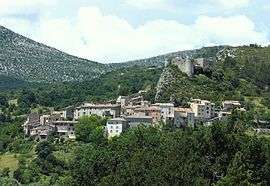 The village overlooked by the castle | ||
| ||
 Trigance Location within Provence-A.-C.d'A. region  Trigance | ||
| Coordinates: 43°45′43″N 6°26′41″E / 43.7619°N 6.4447°ECoordinates: 43°45′43″N 6°26′41″E / 43.7619°N 6.4447°E | ||
| Country | France | |
| Region | Provence-Alpes-Côte d'Azur | |
| Department | Var | |
| Arrondissement | Draguignan | |
| Canton | Flayosc | |
| Government | ||
| • Mayor (2001–2008) | Bernard Clap | |
| Area1 | 60.6 km2 (23.4 sq mi) | |
| Population (2006)2 | 162 | |
| • Density | 2.7/km2 (6.9/sq mi) | |
| Time zone | UTC+1 (CET) | |
| • Summer (DST) | UTC+2 (CEST) | |
| INSEE/Postal code | 83142 /83840 | |
| Elevation |
630–1,270 m (2,070–4,170 ft) (avg. 800 m or 2,600 ft) | |
|
1 French Land Register data, which excludes lakes, ponds, glaciers > 1 km2 (0.386 sq mi or 247 acres) and river estuaries. 2 Population without double counting: residents of multiple communes (e.g., students and military personnel) only counted once. | ||
.svg.png)
Trigance is a commune in the Var department in the Provence-Alpes-Côte d'Azur region in southeastern France.
See also
References
| Wikimedia Commons has media related to Trigance. |
This article is issued from
Wikipedia.
The text is licensed under Creative Commons - Attribution - Sharealike.
Additional terms may apply for the media files.