Grimaud, Var
| Grimaud | ||
|---|---|---|
| Commune | ||
 Grimaud Village | ||
| ||
 Grimaud Location within Provence-A.-C.d'A. region  Grimaud | ||
| Coordinates: 43°16′27″N 6°31′20″E / 43.2742°N 6.5222°ECoordinates: 43°16′27″N 6°31′20″E / 43.2742°N 6.5222°E | ||
| Country | France | |
| Region | Provence-Alpes-Côte d'Azur | |
| Department | Var | |
| Arrondissement | Draguignan | |
| Canton | Sainte-Maxime | |
| Government | ||
| • Mayor (2001–2009) | Alain Benedetto | |
| Area1 | 44.58 km2 (17.21 sq mi) | |
| Population (2006)2 | 3,792 | |
| • Density | 85/km2 (220/sq mi) | |
| Time zone | UTC+1 (CET) | |
| • Summer (DST) | UTC+2 (CEST) | |
| INSEE/Postal code | 83068 /83310 | |
| Elevation |
0–503 m (0–1,650 ft) (avg. 102 m or 335 ft) | |
|
1 French Land Register data, which excludes lakes, ponds, glaciers > 1 km2 (0.386 sq mi or 247 acres) and river estuaries. 2 Population without double counting: residents of multiple communes (e.g., students and military personnel) only counted once. | ||
.svg.png)
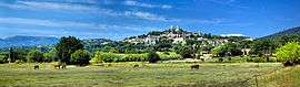
Grimaud is a village and commune in the Var department in the Provence-Alpes-Côte d'Azur region in southeastern France.
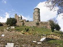
It is located on the French Riviera. The village of Grimaud is a perched village, with historical links to the Grimaldi family. Gibelin de Grimaldi aided William the Good drive the Saracens of Fraxinet out of the area in AD 973 and was rewarded with the land. The village is dominated by its 11th-century castle (partially restored).
The Gulf of Saint Tropez was known as the Gulf of Grimaud until the end of the 19th century. The seaside town of Port Grimaud lies within the commune, at the head of the gulf.
See also
References
External links
- More information about Grimaud and its surroundings
- More photos of Grimaud and its surroundings
- Grimaud Tourist Information
- Site Officiel de la Mairie de Grimaud
| Wikimedia Commons has media related to Grimaud. |