Pontevès
| Pontevès | ||
|---|---|---|
| Commune | ||
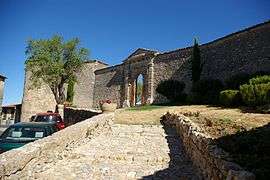 The Château of Pontevès | ||
| ||
 Pontevès Location within Provence-A.-C.d'A. region  Pontevès | ||
| Coordinates: 43°33′16″N 6°01′48″E / 43.5544°N 6.03000000°ECoordinates: 43°33′16″N 6°01′48″E / 43.5544°N 6.03000000°E | ||
| Country | France | |
| Region | Provence-Alpes-Côte d'Azur | |
| Department | Var | |
| Arrondissement | Brignoles | |
| Canton | Saint-Maximin-la-Sainte-Baume | |
| Intercommunality | Provence d'Argens en Verdon | |
| Government | ||
| • Mayor (1997–2014) | Jean-Marc Etienne | |
| Area1 | 41.07 km2 (15.86 sq mi) | |
| Population (2006)2 | 675 | |
| • Density | 16/km2 (43/sq mi) | |
| Demonym(s) | Pontevèsois | |
| Time zone | UTC+1 (CET) | |
| • Summer (DST) | UTC+2 (CEST) | |
| INSEE/Postal code | 83095 /83670 | |
| Elevation |
240–813 m (787–2,667 ft) (avg. 400 m or 1,300 ft) | |
|
1 French Land Register data, which excludes lakes, ponds, glaciers > 1 km2 (0.386 sq mi or 247 acres) and river estuaries. 2 Population without double counting: residents of multiple communes (e.g., students and military personnel) only counted once. | ||
.svg.png)
Pontevès is a commune in the Var department in the Provence-Alpes-Côte d'Azur region in southeastern France.
See also
References
| Wikimedia Commons has media related to Pontevès. |
This article is issued from
Wikipedia.
The text is licensed under Creative Commons - Attribution - Sharealike.
Additional terms may apply for the media files.