Fort Resolution
| Fort Resolution Deninu Kue | |
|---|---|
| Hamlet | |
 | |
 Fort Resolution  Fort Resolution | |
| Coordinates: 61°10′18″N 113°40′18″W / 61.17167°N 113.67167°WCoordinates: 61°10′18″N 113°40′18″W / 61.17167°N 113.67167°W | |
| Country | Canada |
| Territory | Northwest Territories |
| Region | South Slave Region |
| Territorial electoral district | Tu Nedhé-Wiilideh |
| Census division | Region 5 |
| Hamlet | 5 January 2011 |
| Government | |
| • Mayor | Louis Balsillie |
| • Senior Administrative Officer | Tausia Kaitu-Lal |
| • MLA | Tom Beaulieu |
| Area[1] | |
| • Land | 455.22 km2 (175.76 sq mi) |
| Elevation | 160 m (520 ft) |
| Population (2016)[1] | |
| • Total | 470 |
| • Density | 1.0/km2 (3/sq mi) |
| Time zone | UTC-7 (Mountain (MST)) |
| • Summer (DST) | UTC-6 (MDT) |
| Canadian Postal code | X0E 0M0 |
| Area code(s) | 867 |
| Telephone exchange | 394 |
| - Living cost | 142.5A |
| - Food price index | 144.0B |
| Climate | Dsc |
|
Sources: Department of Municipal and Community Affairs,[2] Prince of Wales Northern Heritage Centre,[3] Canada Flight Supplement[4] ^A 2013 figure based on Edmonton = 100[5] ^B 2015 figure based on Yellowknife = 100[5] | |
Fort Resolution (Deninu Kue "moose island") is a hamlet[6] in the South Slave Region of the Northwest Territories, Canada. The community is situated at the mouth of the Slave River, on the shores of Great Slave Lake, and at the end of the Fort Resolution Highway (Highway 6).
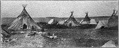
It is the oldest documented European community in the Northwest Territories, built in 1819, and was a key link in the fur trade's water route north. Fort Resolution is designated as a National Historic Site of Canada as the oldest continuously occupied place in the Northwest Territories with origins in the fur trade and the principal fur trade post on Great Slave Lake.[7]
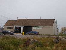
Fort Resolution features "Deninoo School", offering schooling for children K-12. The town also has a hockey arena, community hall, 2 nursing station, Youth Centre, Royal Canadian Mounted Police, bed and breakfast, a 'Northern' general store with a "Quick-Stop" convenience store, Two diners and two gas stations. A small airport, Fort Resolution Airport, services charter and medivac flights only. The oldest building in town is the historic Roman Catholic Church, built in the early 19th century. A second, Protestant, church offers an alternative worship option. The beach along Great Slave Lake is a prime spot for summer swimming, bird watching, fishing or relaxing. Local people engage in fishing, hunting, and trapping year-round.
The nearby site of Pine Point was once a thriving lead mine. When the value of lead plummeted in the 1980s, the Pine Point Mine closed, and the township was evacuated. Pine Point houses were sold cheaply, and many of the buildings were then moved to Fort Resolution (including the hockey arena), Hay River and Northern Alberta.[8]
"Deninoo Days" in late August celebrate the beginning of moose hunting season with parades, traditional races, games and talent competitions. Recreational opportunities include camping, canoeing and fishing (self-guided, or available through several outfitters). "Little Buffalo River Crossing" is a nearby territorial park, with historical and natural attractions, accessible by road and featuring a campground with 12 sites.[9]
Demographics
Population is 470 according to the 2016 Census, a decrease of -0.8% from 2011. Of these 430 were listed as Indigenous. The majority of townspeople are of Dene (320) and Métis (105) descent.[1] The predominant languages are English, Chipewyan and Michif. In 2017 the Government of the Northwest Territories reported that the population was 507 with an average yearly growth rate of 0.0% from 2007.[5]
| Historical population | |||||||||||||||||||||||||||||||||||||||||||||||||||||||||||||||||||||||||
|---|---|---|---|---|---|---|---|---|---|---|---|---|---|---|---|---|---|---|---|---|---|---|---|---|---|---|---|---|---|---|---|---|---|---|---|---|---|---|---|---|---|---|---|---|---|---|---|---|---|---|---|---|---|---|---|---|---|---|---|---|---|---|---|---|---|---|---|---|---|---|---|---|---|
|
| ||||||||||||||||||||||||||||||||||||||||||||||||||||||||||||||||||||||||
| Sources: NWT Bureau of Statistics (2001 - 2017)[10] | |||||||||||||||||||||||||||||||||||||||||||||||||||||||||||||||||||||||||
First Nations
Fort Resolution is represented by the Deninu Kue First Nation and are part of the Akaitcho Territory Government.[11]
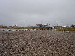
Gallery
_Resolution%2C_Northwest_Territories_-_Pensionnat_indien_catholique_de_(Fort)_Resolution_(Territoires_du_Nord-Ouest)_(14112742441).jpg)
.jpg)

Climate
| Climate data for Fort Resolution | |||||||||||||
|---|---|---|---|---|---|---|---|---|---|---|---|---|---|
| Month | Jan | Feb | Mar | Apr | May | Jun | Jul | Aug | Sep | Oct | Nov | Dec | Year |
| Average high °C (°F) | −25 (−13) |
−20 (−4) |
−14 (6) |
0 (32) |
10 (50) |
17 (62) |
21 (69) |
18 (64) |
11 (51) |
2 (35) |
−9 (15) |
−17 (2) |
0 (32) |
| Average low °C (°F) | −31 (−23) |
−27 (−16) |
−24 (−11) |
−11 (12) |
0 (32) |
5 (41) |
10 (50) |
9 (48) |
3 (37) |
−3 (26) |
−15 (5) |
−25 (−13) |
−9 (15) |
| Average precipitation mm (inches) | 15 (0.6) |
8 (0.3) |
13 (0.5) |
10 (0.4) |
25 (1.0) |
30 (1.2) |
28 (1.1) |
36 (1.4) |
36 (1.4) |
28 (1.1) |
33 (1.3) |
15 (0.6) |
277 (10.9) |
| Source: Weatherbase[12] | |||||||||||||
See also
References
- 1 2 3 Fort Resolution, HAM Northwest Territories (Census subdivision)
- ↑ "NWT Communities - Fort Resolution". Government of the Northwest Territories: Department of Municipal and Community Affairs. Retrieved 13 January 2014.
- ↑ "Northwest Territories Official Community Names and Pronunciation Guide". Prince of Wales Northern Heritage Centre. Yellowknife: Education, Culture and Employment, Government of the Northwest Territories. Archived from the original on 2016-01-13. Retrieved 2016-01-13.
- ↑ Canada Flight Supplement. Effective 0901Z 19 July 2018 to 0901Z 13 September 2018.
- 1 2 3 Fort Resolution - Statistical Profile
- ↑ Differences in Community Government Structure
- ↑ Fort Resolution National Historic Site of Canada. Canadian Register of Historic Places. Retrieved 11 October 2013.
- ↑ Keeling, Arn; Sandlos, John (2012). "Claiming the New North: Development and Colonialism at the Pine Point Mine, Northwest Territories, Canada" (PDF). Faculty of Arts. Memorial University of Newfoundland: 18. ISSN 1752-7023. Lay summary – Memorial University Research Repository.
- ↑ Little Buffalo River Crossing
- ↑ Population Estimates By Community from the GNWT
- ↑ Indian and Northern Affairs Canada Archived 2007-06-11 at Archive.is
- ↑ "Weatherbase: Historical Weather for Fort Resolution, Northwest Territories". Weatherbase. 2011. Retrieved on November 24, 2011.
Further reading
| Wikimedia Commons has media related to Fort Resolution. |
- Deprez, P., & Bisson, A. (1975). Demographic differences between Indians and Métis in Fort Resolution. Winnipeg: Centre for Settlement Studies, University of Manitoba.
- Driedger, L. C. (1990). Kinship, marriage and residence in Fort Resolution, N.W.T. Ottawa: National Library of Canada. ISBN 0-315-55603-X
- Fields, G., & Sigurdson, G. (1972). Northern co-operatives as a strategy for community change; the case of Fort Resolution. Winnipeg: University of Manitoba, Centre for Settlement Studies.
- Fort Resolution Education Society. (1987). That's the way we lived an oral history of the Fort Resolution elders. Fort Resolution, N.W.T.: Fort Resolution Education Society.
- Kim, C. J.-H. (1996). Assessment of cadmium intake from the consumption of traditional food in Fort Resolution, Northwest Territories. Ottawa: National Library of Canada = Bibliothèque nationale du Canada. ISBN 0-612-12213-1
- Lafontaine, C. (1997). Concentrations of metals and trace elements in muscle and liver of fish collected from Great Slave Lake, Fort Resolution area, NWT final report. Yellowknife: The Division.
- Mercredi, M. (1988). An outline for a traditional skills camp proposed by the Fort Resolution Settlement Council. Yellowknife?: Govt. of the Northwest Territories].
- Smith, D. M. (1982). Moose-Deer island house people a history of the native people of Fort Resolution. Ottawa: National Museums of Canada.
- Smith, D. M. (1973). INKONZE: magico-religious beliefs of contract-traditional Chipewan trading at Fort Resolution, NWT, Canada. Mercury series. Ottawa: National Museum of Man, National Museums of Canada.
- Van Kessel, J. C. (2004). Taking care of bison community perceptions of the Hook Lake Wood Bison Recovery Project in Fort Resolution, N.T., Canada. Ottawa: National Library of Canada = Bibliothèque nationale du Canada. ISBN 0-612-81493-9
| Census divisions | |||||||
|---|---|---|---|---|---|---|---|
| Former census divisions | |||||||
| Dehcho Region |
| ||||||
| Inuvik Region |
| ||||||
| North Slave Region |
| ||||||
| Sahtu Region |
| ||||||
| South Slave Region |
| ||||||
| Weather stations (outside of communities) | |||||||
| Mine sites |
| ||||||
| DEW line and NWS sites |
| ||||||
| Hudson's Bay Company trading posts | |||||||
| Former districts |
| ||||||
| |||||||
| Provinces | |
|---|---|
| Territories | |
| Other countries | |
| |