Sahtu Region

Sahtu Region communities in the Northwest Territories
The Sahtu Region is one of five administrative regions in the Northwest Territories in Canada. According to Municipal and Community Affairs the region consists of five communities with the regional office situated in Norman Wells. With the exception of Norman Wells the communities are predominantly First Nations.
Communities
The Sahtu Region includes the following communities:
| Community name[1] | Translation[1] | Governance[2] | Population 2016[3] |
% change from 2011 |
Location |
| Colville Lake[4] | K'áhbamñtúé; ptarmigan net place | Settlement Corporation (Behdzi Ahda First Nation) | 129 | -13.4% | 67°02′18″N 126°05′32″W / 67.03833°N 126.09222°W |
| Deline[5] | where the waters flow | Charter Community | 533 | -12.9% | 65°11′12″N 123°25′18″W / 65.18667°N 123.42167°W |
| Fort Good Hope[6] | Rádeyîlîkóé; rapids place | Charter Community | 516 | 0.2% | 66°15′31″N 128°37′43″W / 66.25861°N 128.62861°W |
| Norman Wells[7] | Tåegõhtî; where there is oil | Town | 778 | 7.0% | 65°16′59″N 126°50′58″W / 65.28306°N 126.84944°W |
| Tulita[8] | where the waters meet | Hamlet | 477 | -0.2% | 64°54′01″N 125°34′39″W / 64.90028°N 125.57750°W |
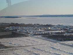
Norman Wells
| Historical population | ||||||||||||||||||||||||||||||||||||||||||||||||||||||||||
|---|---|---|---|---|---|---|---|---|---|---|---|---|---|---|---|---|---|---|---|---|---|---|---|---|---|---|---|---|---|---|---|---|---|---|---|---|---|---|---|---|---|---|---|---|---|---|---|---|---|---|---|---|---|---|---|---|---|---|
|
| |||||||||||||||||||||||||||||||||||||||||||||||||||||||||
| Sources: NWT Bureau of Statistics (2001 - 2017)[9] | ||||||||||||||||||||||||||||||||||||||||||||||||||||||||||
References
- 1 2 "Northwest Territories Official Community Names and Pronunciation Guide". Prince of Wales Northern Heritage Centre. Yellowknife: Education, Culture and Employment, Government of the Northwest Territories. Archived from the original on 2016-01-13. Retrieved 2016-01-13.
- ↑ "Differences in Community Government Structures" (PDF). Maca.gov.nt.ca. Retrieved 18 December 2014.
- ↑ "Population and dwelling counts, for Canada, provinces and territories, and census subdivisions (municipalities), 2016 and 2011 censuses – 100% data".
- ↑ "NWT Communities - Colville Lake". Government of the Northwest Territories: Department of Municipal and Community Affairs. Retrieved 29 January 2014.
- ↑ "NWT Communities - Deline". Government of the Northwest Territories: Department of Municipal and Community Affairs. Retrieved 29 January 2014.
- ↑ "NWT Communities - Fort Good Hope". Government of the Northwest Territories: Department of Municipal and Community Affairs. Retrieved 29 January 2014.
- ↑ "NWT Communities - Norman Wells". Government of the Northwest Territories: Department of Municipal and Community Affairs. Retrieved 29 January 2014.
- ↑ "NWT Communities - Tulita". Government of the Northwest Territories: Department of Municipal and Community Affairs. Retrieved 29 January 2014.
- ↑ Population Estimates By Community from the GNWT
External links
| Census divisions | |||||||
|---|---|---|---|---|---|---|---|
| Former census divisions | |||||||
| Dehcho Region |
| ||||||
| Inuvik Region |
| ||||||
| North Slave Region |
| ||||||
| Sahtu Region |
| ||||||
| South Slave Region |
| ||||||
| Weather stations (outside of communities) | |||||||
| Mine sites |
| ||||||
| DEW line and NWS sites |
| ||||||
| Hudson's Bay Company trading posts | |||||||
| Former districts |
| ||||||
| |||||||
Coordinates: 65°16′52″N 126°49′53″W / 65.28111°N 126.83139°W
This article is issued from
Wikipedia.
The text is licensed under Creative Commons - Attribution - Sharealike.
Additional terms may apply for the media files.