District of Alberta
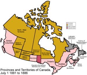
1882 districts are superimposed over the 1881 map
.jpg)
A 1900 map showing the boundaries of the District of Alberta.
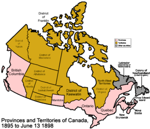
The District of Alberta was one of four districts of the Northwest Territories created in 1882.[1][2] It was styled the Alberta Provisional District to distinguish it from the District of Keewatin which had a more autonomous relationship from the NWT administration. Present-day Province of Alberta takes in the District of Alberta and parts of the Districts of Athabasca, Assiniboia and Saskatchewan.
See also
- Alberta (Provisional District) Former Canadian House of Commons electoral district covering the District of Alberta.
- Territorial evolution of Canada
- District of Saskatchewan
- District of Assiniboia
- District of Athabasca
References
- ↑ Acts of the Parliament of the Dominion of Canada, Ottawa: Brown Chamberlin Law Printer (for Canada), 1886
- ↑ Fung, Professor of Geography, University of Saskatchewan., Dr. K.I.; Richards,, J. Howard, Evolution-boundaries-1882: (1969). Atlas of Saskatchewan. Saskatoon: Modern Press., retrieved 2007-10-12
Coordinates: 51°48′N 113°24′W / 51.80°N 113.40°W
| Physiographic regions |
| ||||||
|---|---|---|---|---|---|---|---|
| Physical features | |||||||
| Parks and protected areas |
| ||||||
| Historic regions | |||||||
| Aboriginal peoples |
| ||||||
| |||||||
This article is issued from
Wikipedia.
The text is licensed under Creative Commons - Attribution - Sharealike.
Additional terms may apply for the media files.