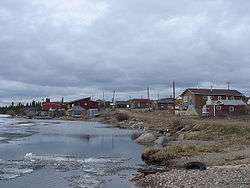
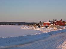
Deline
| Deline Délı̨ne | |
|---|---|
| Charter Community | |
 | |
 Great Bear Lake, NWT, Canada | |
 Deline Location of Deline  Deline Deline (Canada) | |
| Coordinates: 65°11′12″N 123°25′18″W / 65.18667°N 123.42167°WCoordinates: 65°11′12″N 123°25′18″W / 65.18667°N 123.42167°W | |
| Country | Canada |
| Territory | Northwest Territories |
| Region | Sahtu Region |
| Constituency | Sahtu |
| Census division | Region 2 |
| Charter Community | 1 April 1993 |
| Government | |
| • Community Leader | Ekw'atide Leeroy Andre |
| • Community Officer | David Little |
| • MLA | Norman Yakeleya |
| Area[1] | |
| • Land | 79.44 km2 (30.67 sq mi) |
| Elevation | 214 m (702 ft) |
| Population (2011)[1] | |
| • Total | 533 |
| • Density | 6.7/km2 (17/sq mi) |
| Time zone | UTC-7 (Mountain (MST)) |
| • Summer (DST) | UTC-6 (MDT) |
| Canadian Postal code | X0E 0G0 |
| Area code(s) | 867 |
| Telephone exchange | 589 |
| - Living cost | 167.5A |
| - Food price index | 164.5B |
| Website | www.deline.ca |
|
Sources: Department of Municipal and Community Affairs,[2] Prince of Wales Northern Heritage Centre,[3] Canada Flight Supplement[4] ^A 2013 figure based on Edmonton = 100[5] ^B 2015 figure based on Yellowknife = 100[5] | |
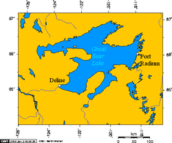
The Charter Community of Délįne (pronounced "day-li-neh") is located in the Sahtu Region of the Northwest Territories, Canada, on the western shore of Great Bear Lake and is 544 km (338 mi) northwest of Yellowknife. Délįne means "where the waters flow", a reference to the headwaters of the Great Bear River, Sahtúdé.
History
According to early records, a trading post was established in this general area as early as 1799 by the North West Company, but it did not last very many years. In 1825, Peter Warren Dease of the Hudson's Bay Company (HBC) erected an outpost here as the staging area and winter quarters for Sir John Franklin's second Arctic expedition (1825–1827). It became known as Fort Franklin. Sir John Franklin's diary records that his men played ice sports very similar to what we now call hockey. As such, the modern-day town promotes itself as one of the birthplaces of the sport of ice hockey.[6]
The HBC returned and established a post called Fort Norman a short distance west, and across the lake narrows, from John Franklin's original post, between 1863 and 1869, and then relocated Fort Norman to its current location at the confluence of the Mackenzie and Bear Rivers (now Tulita).[7]
Fort Franklin as a modern era trading post of the HBC was not established until later in the 19th century. It was constructed at one of the most productive Dene fisheries in the Mackenzie River drainage basin and was for the benefit of the Dene people who lived in near isolation along the shores of Great Bear Lake.
The area became prominent when pitchblende was discovered at the Eldorado Mine, some 250 km (160 mi) away, on the eastern shore, at Port Radium. During World War II, the Canadian Government took over the mine and began to produce uranium for the then-secret American nuclear bomb project. Uranium product was transported from Port Radium by barge across Great Bear Lake where a portage network was established along the Bear River, across the bay from Fort Franklin, where many of the Dene men found work. As the risks associated with radioactive materials were not well communicated, it is believed that many of the Dene were exposed to dangerous amounts of radiation,[8] which Déline residents believe resulted in the development of cancer and led to premature deaths.[9][10]
The name of Fort Franklin was changed on 1 June 1993 to Délįne, which means "where the waters flow", a reference to the headwaters of the Great Bear River, Sahtúdé.
Nearby Saoyú-ʔehdacho, the largest National Historic Site of Canada in the country, was designated in 1997 and is jointly administered by Parks Canada and the Déline First Nation.
In March 2016, a tank truck fell partway through the ice road just a few days after the government had increased the allowed maximum weight limit to 40,000 kg (88,000 lb) on the road. The truck which was 3 km (1.9 mi) outside of Déline, and close to the community's fresh water intake as well as a major fishing area, contained approximately 30,000 l (6,600 imp gal; 7,900 US gal) of heating fuel and was one of 70 truck loads intended to resupply the community. The fuel was removed from the truck by 2 am, 8 March.[11][12][13]
Archaeology
John Franklin's 1825-1827 outpost was excavated by the Prince of Wales Northern Heritage Centre in 1987. The excavation uncovered beads, rings, and buttons indicating the extent of trade between the Dene and Europeans. The site is protected by the Northwest Territories Archaeological Sites Regulations. In 1996, the site was designated a National Historic Site of Canada.[14]
Land claims and self-government
Délįne is represented by the Déline First Nation and belongs to the Sahtu Dene Council.[15] Through the council, they completed negotiations with the Government of Canada for a comprehensive land claim settlement in 1993.
Pursuant to the 1993 Sahtu Dene and Metis Comprehensive Land Claim Agreement, Déline subsequently negotiated a self-government agreement with the Government of the Northwest Territories and the Government of Canada. The Final Self-Government Agreement was ratified by a majority vote of Déline's membership in March 2014. The Final Self-Government Agreement was signed by its leadership, by the Government of the Northwest Territories and by the Government of Canada in February 2015, enacted by the Legislative Assembly of the Northwest Territories in March 2015, and enacted by the Parliament of Canada in June 2015 through Bill C-63. The Final Self-Government Agreement is a Treaty within the meaning of ss. 25 and 35 of the Constitution Act, 1982, and, once in effect, will cause much of the Indian Act to cease to apply to Déline's citizens.
Demographics
The population at the 2016 census was 533, a increase of 12.9% from the 2011 census.[1] In the 2016 Census, there were 495 Indigenous people made up of 485 First Nations, Sahtu Dene people speaking North Slavey and 10 Métis people..[1] In 2017, the Government of the Northwest Territories reported that the population was 510, with an average yearly growth rate of -0.4% from 2006.[5]
| Historical population | |||||||||||||||||||||||||||||||||||||||||||||||||||||||||||||||||||||||||
|---|---|---|---|---|---|---|---|---|---|---|---|---|---|---|---|---|---|---|---|---|---|---|---|---|---|---|---|---|---|---|---|---|---|---|---|---|---|---|---|---|---|---|---|---|---|---|---|---|---|---|---|---|---|---|---|---|---|---|---|---|---|---|---|---|---|---|---|---|---|---|---|---|---|
|
| ||||||||||||||||||||||||||||||||||||||||||||||||||||||||||||||||||||||||
| Sources: NWT Bureau of Statistics (2001 - 2017)[16] | |||||||||||||||||||||||||||||||||||||||||||||||||||||||||||||||||||||||||
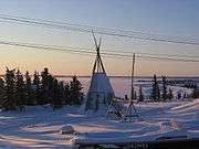
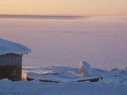
Gallery
Climate
| Climate data for Deline Airport | |||||||||||||
|---|---|---|---|---|---|---|---|---|---|---|---|---|---|
| Month | Jan | Feb | Mar | Apr | May | Jun | Jul | Aug | Sep | Oct | Nov | Dec | Year |
| Record high humidex | 2.8 | 0.5 | 3.8 | 16.6 | 22.8 | 29.8 | 33.5 | 31.8 | 22.9 | 20.5 | 2.4 | 0.3 | 33.5 |
| Record high °C (°F) | 2.5 (36.5) |
1.0 (33.8) |
4.0 (39.2) |
16.0 (60.8) |
22.5 (72.5) |
29.3 (84.7) |
31.0 (87.8) |
32.0 (89.6) |
23.5 (74.3) |
20.8 (69.4) |
4.8 (40.6) |
3.3 (37.9) |
32.0 (89.6) |
| Average high °C (°F) | −20.9 (−5.6) |
−18.5 (−1.3) |
−13.9 (7) |
−1.9 (28.6) |
7.4 (45.3) |
16.8 (62.2) |
19.4 (66.9) |
16.6 (61.9) |
10.2 (50.4) |
−0.8 (30.6) |
−11.5 (11.3) |
−17.6 (0.3) |
−1.2 (29.8) |
| Daily mean °C (°F) | −25.0 (−13) |
−23.2 (−9.8) |
−19.5 (−3.1) |
−7.7 (18.1) |
2.5 (36.5) |
10.7 (51.3) |
13.3 (55.9) |
11.2 (52.2) |
5.7 (42.3) |
−3.9 (25) |
−15.4 (4.3) |
−22.0 (−7.6) |
−6.1 (21) |
| Average low °C (°F) | −28.9 (−20) |
−27.8 (−18) |
−25.1 (−13.2) |
−13.6 (7.5) |
−2.5 (27.5) |
4.4 (39.9) |
7.2 (45) |
5.8 (42.4) |
1.3 (34.3) |
−7.0 (19.4) |
−19.2 (−2.6) |
−26.3 (−15.3) |
−11.0 (12.2) |
| Record low °C (°F) | −49.1 (−56.4) |
−43.3 (−45.9) |
−43.3 (−45.9) |
−35.0 (−31) |
−23.3 (−9.9) |
−4.0 (24.8) |
−1.8 (28.8) |
−4.9 (23.2) |
−13.3 (8.1) |
−29.7 (−21.5) |
−37.4 (−35.3) |
−43.0 (−45.4) |
−49.1 (−56.4) |
| Record low wind chill | −57.2 | −54.0 | −55.3 | −40.4 | −27.6 | −6.4 | 0.0 | −3.6 | −16.3 | −34.4 | −46.7 | −54.7 | −57.2 |
| Average precipitation mm (inches) | 10.3 (0.406) |
11.2 (0.441) |
10.3 (0.406) |
10.1 (0.398) |
14.8 (0.583) |
24.3 (0.957) |
40.3 (1.587) |
43.2 (1.701) |
39.5 (1.555) |
31.1 (1.224) |
21.7 (0.854) |
11.9 (0.469) |
268.7 (10.579) |
| Average rainfall mm (inches) | 0.0 (0) |
0.0 (0) |
0.0 (0) |
0.1 (0.004) |
12.2 (0.48) |
24.2 (0.953) |
40.3 (1.587) |
43.2 (1.701) |
37.1 (1.461) |
4.9 (0.193) |
0.4 (0.016) |
0.0 (0) |
162.3 (6.39) |
| Average snowfall cm (inches) | 13.0 (5.12) |
16.9 (6.65) |
17.1 (6.73) |
12.3 (4.84) |
3.4 (1.34) |
0.2 (0.08) |
0.0 (0) |
0.0 (0) |
2.4 (0.94) |
32.2 (12.68) |
35.2 (13.86) |
17.3 (6.81) |
150.0 (59.06) |
| Average precipitation days (≥ 0.2 mm) | 5.4 | 6.8 | 7.5 | 3.9 | 6.1 | 8.0 | 10.4 | 12.3 | 12.4 | 12.4 | 10.1 | 7.2 | 102.4 |
| Average rainy days (≥ 0.2 mm) | 0.0 | 0.0 | 0.0 | 0.2 | 4.5 | 8.0 | 10.4 | 12.3 | 11.8 | 2.4 | 0.1 | 0.0 | 49.7 |
| Average snowy days (≥ 0.2 cm) | 6.7 | 7.5 | 9.4 | 4.2 | 1.7 | 0.1 | 0.0 | 0.0 | 0.9 | 10.5 | 11.4 | 8.9 | 61.4 |
| Average relative humidity (%) | 74.9 | 76.1 | 76.7 | 75.0 | 63.0 | 54.5 | 58.2 | 62.1 | 65.7 | 82.6 | 82.5 | 76.1 | 70.6 |
| Source: Environment Canada Canadian Climate Normals 1981–2010[17] | |||||||||||||
See also
References
- 1 2 3 4 Census Profile, 2016 Census Déline, Chartered community (Census subdivision), Northwest Territories and Northwest Territories (Territory)
- ↑ "NWT Communities - Deline". Government of the Northwest Territories: Department of Municipal and Community Affairs. Retrieved 2013-01-21.
- ↑ "Northwest Territories Official Community Names and Pronunciation Guide". Prince of Wales Northern Heritage Centre. Yellowknife: Education, Culture and Employment, Government of the Northwest Territories. Archived from the original on 2016-01-13. Retrieved 2016-01-13.
- ↑ Canada Flight Supplement. Effective 0901Z 19 July 2018 to 0901Z 13 September 2018.
- 1 2 3 "Deline - Statistical Profile (2006-2017)" (PDF). NWT Bureau of Statistics. Archived (PDF) from the original on 2018-08-29.
- ↑ Boswell, Randy (17 September 2011). "Deline, NWT: The 'birthplace' of hockey?". NunatsiaqOnline. Nunatsiaq News. Archived from the original on 9 February 2015. Retrieved 9 February 2015.
- ↑ Petitot, Emile. Travels Around Great Slave and Great Bear Lakes, 1862–1882. Toronto: The Champlain Society, 2005.
- ↑ They Never Told Us These Things
- ↑ "7 Sep 1998, Page 54 - at Newspapers.com". Newspapers.com. Retrieved 2016-03-25.
- ↑ "A Village of Widows". arcticcircle.uconn.edu. Retrieved 2016-03-25.
- ↑ "Fuel tanker plunges through Deline, N.W.T., ice road". CBC News. 5 March 2016. Retrieved 14 March 2016.
- ↑ "N.W.T. hopes to remove fuel from tanker stuck in ice near Deline quickly". CBC News. 7 March 2016. Retrieved 15 March 2016.
- ↑ "Fuel load successfully drained from tanker stuck in ice near Deline, N.W.T." CBC News. 8 March 2016. Retrieved 15 March 2016.
- ↑ Déline Fishery / Franklin's Fort National Historic Site of Canada. Canadian Register of Historic Places. Retrieved 4 October 2013.
- ↑ Indian and Northern Affairs Canada
- ↑ Population Estimates By Community from the GNWT
- ↑ "Deline A" (CSV (3069 KB)). Canadian Climate Normals 1981–2010. Environment Canada. Climate ID: 22010KA. Retrieved 2014-01-09.
- John Price, "Our own atomic victims," Victoria Times-Colonist
External links
| Wikimedia Commons has media related to Deline. |
| Census divisions | |||||||
|---|---|---|---|---|---|---|---|
| Former census divisions | |||||||
| Dehcho Region |
| ||||||
| Inuvik Region |
| ||||||
| North Slave Region |
| ||||||
| Sahtu Region |
| ||||||
| South Slave Region |
| ||||||
| Weather stations (outside of communities) | |||||||
| Mine sites |
| ||||||
| DEW line and NWS sites |
| ||||||
| Hudson's Bay Company trading posts | |||||||
| Former districts |
| ||||||
| |||||||