Formerie
| Formerie | ||
|---|---|---|
| Commune | ||
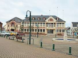 The town hall in Formerie | ||
| ||
 Formerie Location within Hauts-de-France region  Formerie | ||
| Coordinates: 49°39′04″N 1°43′50″E / 49.6511°N 1.7306°ECoordinates: 49°39′04″N 1°43′50″E / 49.6511°N 1.7306°E | ||
| Country | France | |
| Region | Hauts-de-France | |
| Department | Oise | |
| Arrondissement | Beauvais | |
| Canton | Grandvilliers | |
| Intercommunality | Picardie Verte | |
| Government | ||
| • Mayor (2008–2014) | William Bous | |
| Area1 | 8.45 km2 (3.26 sq mi) | |
| Population (2012)2 | 2,098 | |
| • Density | 250/km2 (640/sq mi) | |
| Time zone | UTC+1 (CET) | |
| • Summer (DST) | UTC+2 (CEST) | |
| INSEE/Postal code | 60245 /60220 | |
| Elevation | 206–229 m (676–751 ft) | |
|
1 French Land Register data, which excludes lakes, ponds, glaciers > 1 km2 (0.386 sq mi or 247 acres) and river estuaries. 2 Population without double counting: residents of multiple communes (e.g., students and military personnel) only counted once. | ||
Formerie is a commune in the Oise department in northern France.
See also
References
| Wikimedia Commons has media related to Formerie. |
This article is issued from
Wikipedia.
The text is licensed under Creative Commons - Attribution - Sharealike.
Additional terms may apply for the media files.