Forgès
| Forgès | ||
|---|---|---|
| Commune | ||
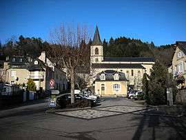 The church and square in Forgès | ||
| ||
 Forgès Location within Nouvelle-Aquitaine region  Forgès | ||
| Coordinates: 45°09′23″N 1°52′15″E / 45.1564°N 1.8708°ECoordinates: 45°09′23″N 1°52′15″E / 45.1564°N 1.8708°E | ||
| Country | France | |
| Region | Nouvelle-Aquitaine | |
| Department | Corrèze | |
| Arrondissement | Tulle | |
| Canton | Argentat | |
| Intercommunality | Pays d'Argentat | |
| Government | ||
| • Mayor (2008–2014) | Christiane Cure | |
| Area1 | 10.43 km2 (4.03 sq mi) | |
| Population (2008)2 | 315 | |
| • Density | 30/km2 (78/sq mi) | |
| Time zone | UTC+1 (CET) | |
| • Summer (DST) | UTC+2 (CEST) | |
| INSEE/Postal code | 19084 /19380 | |
| Elevation |
207–455 m (679–1,493 ft) (avg. 228 m or 748 ft) | |
|
1 French Land Register data, which excludes lakes, ponds, glaciers > 1 km2 (0.386 sq mi or 247 acres) and river estuaries. 2 Population without double counting: residents of multiple communes (e.g., students and military personnel) only counted once. | ||
.svg.png)
Forgès is a commune in the Corrèze department in central France.
Population
| Historical population | ||
|---|---|---|
| Year | Pop. | ±% |
| 1962 | 403 | — |
| 1968 | 461 | +14.4% |
| 1975 | 375 | −18.7% |
| 1982 | 356 | −5.1% |
| 1990 | 344 | −3.4% |
| 1999 | 319 | −7.3% |
| 2008 | 315 | −1.3% |
See also
References
| Wikimedia Commons has media related to Forgès. |
This article is issued from
Wikipedia.
The text is licensed under Creative Commons - Attribution - Sharealike.
Additional terms may apply for the media files.