Branceilles
| Branceilles | ||
|---|---|---|
| Commune | ||
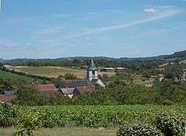 Branceilles (2015) | ||
| ||
 Branceilles Location within Nouvelle-Aquitaine region  Branceilles | ||
| Coordinates: 45°00′43″N 1°42′39″E / 45.0119°N 1.7108°ECoordinates: 45°00′43″N 1°42′39″E / 45.0119°N 1.7108°E | ||
| Country | France | |
| Region | Nouvelle-Aquitaine | |
| Department | Corrèze | |
| Arrondissement | Brive-la-Gaillarde | |
| Canton | Midi Corrézien | |
| Intercommunality | Villages du Midi Corrézien | |
| Government | ||
| • Mayor (2008–2014) | Georges Leymat | |
| Area1 | 11.59 km2 (4.47 sq mi) | |
| Population (2008)2 | 251 | |
| • Density | 22/km2 (56/sq mi) | |
| Time zone | UTC+1 (CET) | |
| • Summer (DST) | UTC+2 (CEST) | |
| INSEE/Postal code | 19029 /19500 | |
| Elevation |
122–244 m (400–801 ft) (avg. 120 m or 390 ft) | |
|
1 French Land Register data, which excludes lakes, ponds, glaciers > 1 km2 (0.386 sq mi or 247 acres) and river estuaries. 2 Population without double counting: residents of multiple communes (e.g., students and military personnel) only counted once. | ||
.svg.png)
Branceilles is a commune of the Corrèze department in central France.
Population
| Historical population | ||
|---|---|---|
| Year | Pop. | ±% |
| 1962 | 321 | — |
| 1968 | 350 | +9.0% |
| 1975 | 308 | −12.0% |
| 1982 | 272 | −11.7% |
| 1990 | 225 | −17.3% |
| 1999 | 236 | +4.9% |
| 2008 | 251 | +6.4% |
See also
References
| Wikimedia Commons has media related to Branceilles. |
This article is issued from
Wikipedia.
The text is licensed under Creative Commons - Attribution - Sharealike.
Additional terms may apply for the media files.