Lostanges
| Lostanges | ||
|---|---|---|
| Commune | ||
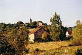 A general view of Lostanges | ||
| ||
 Lostanges Location within Nouvelle-Aquitaine region  Lostanges | ||
| Coordinates: 45°03′47″N 1°45′51″E / 45.0631°N 1.7642°ECoordinates: 45°03′47″N 1°45′51″E / 45.0631°N 1.7642°E | ||
| Country | France | |
| Region | Nouvelle-Aquitaine | |
| Department | Corrèze | |
| Arrondissement | Brive-la-Gaillarde | |
| Canton | Midi Corrézien | |
| Intercommunality | Villages du Midi Corrézien | |
| Government | ||
| • Mayor (2008–2014) | Jérôme Madeleine | |
| Area1 | 9.46 km2 (3.65 sq mi) | |
| Population (2008)2 | 129 | |
| • Density | 14/km2 (35/sq mi) | |
| Time zone | UTC+1 (CET) | |
| • Summer (DST) | UTC+2 (CEST) | |
| INSEE/Postal code | 19119 /19500 | |
| Elevation |
146–515 m (479–1,690 ft) (avg. 275 m or 902 ft) | |
|
1 French Land Register data, which excludes lakes, ponds, glaciers > 1 km2 (0.386 sq mi or 247 acres) and river estuaries. 2 Population without double counting: residents of multiple communes (e.g., students and military personnel) only counted once. | ||
Lostanges is a commune in the Corrèze department in central France.
Population
| Historical population | ||
|---|---|---|
| Year | Pop. | ±% |
| 1962 | 176 | — |
| 1968 | 171 | −2.8% |
| 1975 | 140 | −18.1% |
| 1982 | 147 | +5.0% |
| 1990 | 127 | −13.6% |
| 1999 | 134 | +5.5% |
| 2008 | 129 | −3.7% |
See also
References
| Wikimedia Commons has media related to Lostanges. |
This article is issued from
Wikipedia.
The text is licensed under Creative Commons - Attribution - Sharealike.
Additional terms may apply for the media files.