Meymac
| Meymac | ||
|---|---|---|
| Commune | ||
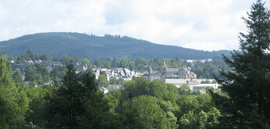 A general view of Meymac | ||
| ||
 Meymac Location within Nouvelle-Aquitaine region  Meymac | ||
| Coordinates: 45°32′12″N 2°08′52″E / 45.5367°N 2.1478°ECoordinates: 45°32′12″N 2°08′52″E / 45.5367°N 2.1478°E | ||
| Country | France | |
| Region | Nouvelle-Aquitaine | |
| Department | Corrèze | |
| Arrondissement | Ussel | |
| Canton | Plateau de Millevaches | |
| Intercommunality | Haute-Corrèze Communauté | |
| Government | ||
| • Mayor (2001–2008) | Serge Vialle | |
| Area1 | 87.15 km2 (33.65 sq mi) | |
| Population (2008)2 | 2,625 | |
| • Density | 30/km2 (78/sq mi) | |
| Time zone | UTC+1 (CET) | |
| • Summer (DST) | UTC+2 (CEST) | |
| INSEE/Postal code | 19136 /19250 | |
| Elevation | 593–973 m (1,946–3,192 ft) | |
|
1 French Land Register data, which excludes lakes, ponds, glaciers > 1 km2 (0.386 sq mi or 247 acres) and river estuaries. 2 Population without double counting: residents of multiple communes (e.g., students and military personnel) only counted once. | ||
.svg.png)
Meymac (Occitan: Maismac) is a commune in the department of Corrèze, in central France.
History
During the Hundred Years' War it was pillaged by Rodrigo de Villandrando.
Geography
The commune lies just south of the Millevaches Plateau and northwest of the Cantal mountains.
The Luzège has its source in the northern part of the commune; it flows south through the middle of the commune and crosses the town.
The Triouzoune forms most of the commune's eastern boundary.
Population
| Historical population | ||
|---|---|---|
| Year | Pop. | ±% |
| 1962 | 2,411 | — |
| 1968 | 2,410 | −0.0% |
| 1975 | 2,434 | +1.0% |
| 1982 | 2,523 | +3.7% |
| 1990 | 2,796 | +10.8% |
| 1999 | 2,623 | −6.2% |
| 2008 | 2,625 | +0.1% |

Mont Bessou viewing tower at the highest point on the Plateau de Millevaches
Sights
See also
References
External links
| Wikimedia Commons has media related to Meymac. |
- (in French) Meymac and the Mont Bessou, its observation tower, photos of the panorama and the surroundings
| Authority control |
|---|
This article is issued from
Wikipedia.
The text is licensed under Creative Commons - Attribution - Sharealike.
Additional terms may apply for the media files.