Misje
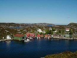 View of the island | |
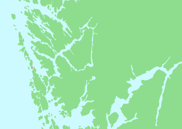 Location in Hordaland county | |
| Geography | |
|---|---|
| Location | Hordaland, Norway |
| Coordinates | 60°27′03″N 4°57′20″E / 60.4508°N 4.9556°ECoordinates: 60°27′03″N 4°57′20″E / 60.4508°N 4.9556°E |
| Area | 1.16 km2 (0.45 sq mi) |
| Length | 2.1 km (1.3 mi) |
| Width | 935 m (3,068 ft) |
| Coastline | 4.9 km (3.04 mi) |
| Highest elevation | 59 m (194 ft) |
| Highest point | Storhaugen |
| Administration | |
| County | Hordaland |
| Municipality | Fjell |
| Demographics | |
| Population | 257 (2009) |
Misje is an island (and village) in Fjell municipality in Hordaland county, Norway. The 1.16-square-kilometre (0.45 sq mi) island lies just south of the island of Toftøyna and north of the large island of Sotra. Almost all of the 257 inhabitants (as of 2009) live on the eastern part of the island, which is referred to as the village of Misje.[1][2]
Historically, the island was part of the old municipality of Herdla. In 1964, it was transferred to the newly established municipality of Fjell. The island has been connected to the neighboring island of Sotra by the Solviksundet Bridge since 1982. Sotra, in turn, is connected to the mainland by a series of bridges.
See also
References
- ↑ Statistics Norway. "Tettsteder. Folkemengde og areal, etter kommune. 1. januar 2009". Retrieved 29 January 2011.
- ↑ Store norske leksikon. "Misje" (in Norwegian). Retrieved 2014-12-01.
This article is issued from
Wikipedia.
The text is licensed under Creative Commons - Attribution - Sharealike.
Additional terms may apply for the media files.