Fejér County
| Fejér County Fejér megye | |||
|---|---|---|---|
| Counties of Hungary | |||
_4.jpg) 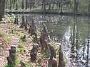  Descending, from top: Holland House in the park of the Festetich Palace in Dég, Arboretum of Alcsútdoboz, and Downtown of Székesfehérvár | |||
| |||
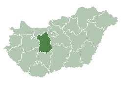 Fejér County within Hungary | |||
| Country |
| ||
| Region | Central Transdanubia | ||
| County seat | Székesfehérvár | ||
| Districts | |||
| Government | |||
| • President of the General Assembly | Dr. Krisztián Molnár (Fidesz-KDNP) | ||
| Area | |||
| • Total | 4,358.45 km2 (1,682.81 sq mi) | ||
| Area rank | 11th in Hungary | ||
| Population (2015) | |||
| • Total | 417,651[1] | ||
| • Rank | 7th in Hungary | ||
| Postal code |
206x, 209x, 24xx, 700x – 701x, 7041, 80xx, 811x – 815x | ||
| Area code(s) | (+36) 22, 25 | ||
| ISO 3166 code | HU-FE | ||
| Website |
www | ||

Fejér (Hungarian: Fejér megye, pronounced [ˈfɛjeːr]) is an administrative county (comitatus or megye) in Central Hungary. It lies on the west bank of the river Danube and nearly touches the eastern shore of Lake Balaton. It shares borders with the Hungarian counties Veszprém, Komárom-Esztergom, Pest, Bács-Kiskun, Tolna and Somogy. The capital of Fejér county is Székesfehérvár.
Geography
Geographically, Fejér County is very diverse; its southern part is similar (and adjacent) to the Great Hungarian Plain, and other parts are hilly (Bakony, Vértes, Gerecse mountains). Lake Velence, a popular resort, is also located there.
History
Before the Conquest
The area was already inhabited 20,000 years ago. When this part of Hungary formed a Roman province called Pannonia, several settlements stood here: the capital was Gorsium, but there were other significant towns too, where present-day Baracs and Dunaújváros are (the towns were called Annamatia and Intercisa, respectively). In the early Medieval period Huns and Avars lived in the area. After 586 several nomadic people inhabited in the area, until Hungarians conquered it in the late 9th century.
From the Conquest until the Ottoman occupation
Hungarians arrived in the area between 895 and 900. The high prince and his tribe settled down in this area. The town of Fehérvár (modern-day Székesfehérvár) became significant as the seat of Prince Géza. Under the reign of his son, King Stephen, the town became the county seat of the newly formed county. Kings of Hungary were crowned and buried in the town until the 16th century.
Fejér under Ottoman rule
Fejér county was occupied by Ottomans between 1543 and 1688. Several of the villages were destroyed, the population dramatically decreased. After being freed from Ottoman rule, local administration was reorganized in 1692. Székesfehérvár got back its town status only in 1703.
Demographics
Religion in Fejér County (2011 census)
In 2015, it had a population of 417,651 and the population density was 96/km².
| Year | County population[2] | Change |
|---|---|---|
| 1949 | 295,750 | n/a |
| 1960 | 21.01% | |
| 1970 | 9.33% | |
| 1980 | 7.42% | |
| 1990 | -0.35% | |
| 2001 | 3.69% | |
| 2011 | -1.95% |
Ethnicity
Besides the Hungarian majority, the main minorities are the Roma (approx. 6,500), Germans (5,500).
Total population (2011 census): 425,847
Ethnic groups (2011 census):[3]
Identified themselves: 372 538 persons:
- Hungarians: 356 982 (95,82%)
- Gypsies: 6 277 (1,68%)
- Germans: 5 419 (1,45%)
- Others and indefinable: 3 860 (1,04%)
Approx. 65,000 persons in Fejér County did not declare their ethnic group at the 2011 census.
Religion
Religious adherence in the county according to 2011 census:[4]
- Catholic – 152,234 (Roman Catholic – 150,883; Greek Catholic – 1,292);
- Reformed – 46,154;
- Evangelical – 7,143;
- Orthodox – 418;
- other religions – 5,524;
- Non-religious – 82,975;
- Atheism – 6,427;
- Undeclared – 124,972.
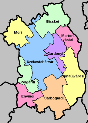
Regional structure
| № | English and Hungarian names |
Area (km²) |
Population (2013) |
Density (pop./km²) |
Seat | № of municipalities |
| 1 | Bicske District Bicskei járás |
578.25 | 35,660 | 62 | Bicske | 15 |
| 2 | Dunaújváros District Dunaújvárosi járás |
650.05 | 91,854 | 141 | Dunaújváros | 16 |
| 3 | Enying District Enyingi járás |
433.12 | 13,187 | 47 | Enying | 9 |
| 4 | Gárdony District Gárdonyi járás |
306.79 | 29,775 | 97 | Gárdony | 10 |
| 5 | Martonvásár District Martonvásári járás |
277.13 | 26,531 | 96 | Martonvásár | 8 |
| 6 | Mór District Móri járás |
417.55 | 34,431 | 83 | Mór | 13 |
| - | Polgárdi District Polgárdi járás |
defunct from 1st January 2015 | ||||
| 7 | Sárbogárd District Sárbogárdi járás |
653.52 | 28,509 | 44 | Sárbogárd | 12 |
| 8 | Székesfehérvár District Székesfehérvári járás |
1,032.05 | 156,935 | 152 | Székesfehérvár | 25 |
| Fejér County | 4,358.75 | 425,847 | 98 | Székesfehérvár | 108 | |
|---|---|---|---|---|---|---|
Politics

The Fejér County Council, elected at the 2014 local government elections, is made up of 20 counselors, with the following party composition:[5]
| Party | Seats | Current County Assembly | |||||||||||||
|---|---|---|---|---|---|---|---|---|---|---|---|---|---|---|---|
| Fidesz-KDNP | 13 | ||||||||||||||
| Movement for a Better Hungary (Jobbik) | 4 | ||||||||||||||
| Hungarian Socialist Party (MSZP) | 2 | ||||||||||||||
| Democratic Coalition (DK) | 1 | ||||||||||||||
Presidents of the General Assembly
| List of Presidents, from 1990[6] | |
|---|---|
| Dr. Krisztián Molnár (Fidesz-KDNP) | 2014– |
Municipalities
Fejér County has 2 urban counties, 15 towns, 10 large villages and 79 villages.
- Cities with county rights
(ordered by population, as of 2011 census)
- Székesfehérvár (100,570)
- Dunaújváros (48,484)
- Towns
- Villages
- Alap
- Alcsútdoboz
- Alsószentiván
- Bakonycsernye
- Bakonykúti
- Balinka
- Baracs
- Baracska
- Beloiannisz
- Besnyő
- Bodmér
- Cece

- Csabdi
- Csákberény
- Csókakő
- Csősz
- Csór
- Daruszentmiklós
- Dég
- Előszállás
- Etyek
- Fehérvárcsurgó
- Felcsút
- Füle
- Gánt
- Gyúró
- Hantos
- Igar
- Iszkaszentgyörgy
- Isztimér
- Iváncsa
- Jenő
- Kajászó
- Káloz
- Kápolnásnyék
- Kincsesbánya
- Kisapostag
- Kisláng
- Kőszárhegy
- Kulcs
- Lajoskomárom
- Lepsény
- Lovasberény
- Magyaralmás
- Mány
- Mátyásdomb
- Mezőfalva
- Mezőkomárom
- Mezőszentgyörgy
- Mezőszilas
- Moha
- Nadap
- Nádasdladány
- Nagykarácsony
- Nagylók
- Nagyveleg
- Nagyvenyim
- Óbarok
- Pákozd
- Pátka
- Pázmánd
- Perkáta
- Pusztavám
- Ráckeresztúr
- Sáregres
- Sárkeresztes
- Sárkeresztúr
- Sárkeszi
- Sárosd
- Sárszentágota
- Sárszentmihály
- Seregélyes
- Soponya
- Söréd
- Sóskút
- Sukoró
- Szabadbattyán
- Szabadegyháza
- Szabadhídvég
- Szár
- Tabajd
- Tác
- Tordas
- Újbarok
- Úrhida
- Vajta
- Vál
- Vereb
- Vértesacsa
- Vértesboglár
- Zámoly
- Zichyújfalu
![]()
Gallery
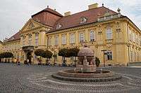 Székesfehérvár, the City of Kings
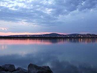 Lake Velence, Hungary's 4th largest lake
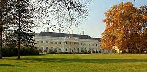 Esterházy Mansion, Csákvár
_(13220._sz%C3%A1m%C3%BA_m%C5%B1eml%C3%A9k).jpg) Arboretum in Alcsútdoboz
Arboretum in Alcsútdoboz_7.jpg) Károlyi Mansion in Fehérvárcsurgó
Károlyi Mansion in Fehérvárcsurgó_6.jpg) Nádady Mansion in Nádasdladány
Nádady Mansion in Nádasdladány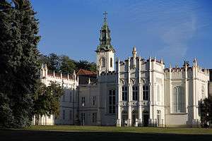 Brunszvik Mansion in Martonvásár
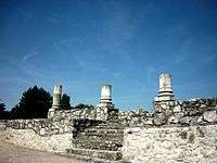 An open-air museum presents the Roman Empire ruins in Tác
References
| Wikimedia Commons has media related to Fejér County. |
| Wikivoyage has a travel guide for Fejér County. |
- ↑ nepesseg.com, population data of Hungarian settlements
- ↑ népesség.com, "Fejér megye népessége 1870-2015"
- ↑ 1.1.6. A népesség anyanyelv, nemzetiség és nemek szerint – Frissítve: 2013.04.17.; Hungarian Central Statistical Office (in Hungarian)
- ↑ 2011. ÉVI NÉPSZÁMLÁLÁS, 3. Területi adatok, 3.7 Fejér megye, (in Hungarian)
- ↑ FEJÉR MEGYEI KÖZGYŰLÉS, (in Hungarian)
- ↑ Önkormányzati választások eredményei (in Hungarian)
External links
| Cities with county rights |
|  |
|---|---|---|
| Towns | ||
| Large villages | ||
| Villages |
| |
| Other topics |
| |
Coordinates: 47°10′N 18°35′E / 47.167°N 18.583°E
| Authority control |
|---|