Heves County
| Heves County Heves megye | |||
|---|---|---|---|
| Counties of Hungary | |||
  .jpg) | |||
| |||
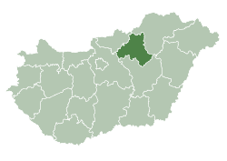 Heves County within Hungary | |||
| Country |
| ||
| Region | Northern Hungary | ||
| County seat | Eger | ||
| Districts | |||
| Government | |||
| • President of the General Assembly | Róbert Szabó (Fidesz-KDNP) | ||
| Area | |||
| • Total | 3,637.21 km2 (1,404.33 sq mi) | ||
| Area rank | 16th in Hungary | ||
| Population (2015) | |||
| • Total | 301,296[1] | ||
| • Rank | 14th in Hungary | ||
| Postal code |
300x – 304x, 32xx – 33xx | ||
| Area code(s) | (+36) 36, 37 | ||
| ISO 3166 code | HU-HE | ||
| Website |
www | ||

Heves (Hungarian: Heves megye, pronounced [ˈhɛvɛʃ]) lies in northern Hungary. It lies between the right bank of the river Tisza and the Mátra and Bükk mountains. It shares borders with the Hungarian counties Pest, Nógrád, Borsod-Abaúj-Zemplén and Jász-Nagykun-Szolnok. Eger is the county seat.
Tourist sights
- Lake Tisza
- Bükk National Park
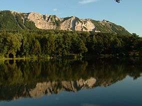
- Bélapátfalva, abbey
- Castle and City of Eger
- Erdőtelek Arboretum
- Feldebrő, 11th century Romanesque church
- Gyöngyös, Mátra Museum
- Hatvan, Grassalkovich mansion
- Kisnána castle
- Noszvaj, De la Motte mansion
- Parád
- Sirok castle
- Szilvásvárad, Szalajka Valley
- Szarvaskő, castle ruins
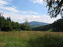
Geography
Heves county is a geographically diverse area; its northern part is mountainous (the Mátra and Bükk are the two highest mountain ranges in Hungary), while at south it includes a part of the Great Hungarian Plain. From south it is bordered by Lake Tisza, the largest artificial lake in Hungary. The average temperature is between 8 and 10 °C (higher on the southern parts of the county).
Rivers
Highest point
Lowest point
- Kisköre (86 m.)
Demographics
Religion in Heves County (2011 census)
In 2015, it had a population of 301,296 and the population density was 83/km².
| Year | County population[2] | Change |
|---|---|---|
| 1949 | 316,273 | n/a |
| 1960 | 9.99% | |
| 1970 | -2.22% | |
| 1980 | 3.00% | |
| 1990 | -4.55% | |
| 2001 | -2.60% | |
| 2011 | -5.17% |
Ethnicity
Besides the Hungarian majority, the main minorities are the Roma (approx. 19,000), Germans (1,000) Slovaks (500) and Romanians (500).
Total population (2011 census): 308,882
Ethnic groups (2011 census):[3]
Identified themselves: 279,714 persons:
- Hungarians: 257,659 (92.12%)
- Gypsies: 19,312 (6.90%)
- Others and indefinable: 2,743 (0.98%)
Approx. 43,000 persons in Heves County did not declare their ethnic group at the 2011 census.
Religion
Religious adherence in the county according to 2011 census:[4]
- Catholic – 162,014 (Roman Catholic – 160,885; Greek Catholic – 1,098);
- Reformed – 14,729;
- Evangelical – 1,084;
- Other religions – 4,894;
- Non-religious – 43,193;
- Atheism – 3,298;
- Undeclared – 79,670.
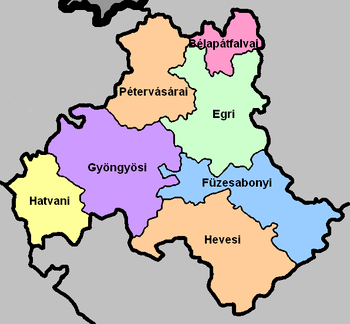
Regional structure
| № | English and Hungarian names |
Area (km²) |
Population (2011) |
Density (pop./km²) |
Seat | № of municipalities |
| 1 | Bélapátfalva District Bélapátfalvai járás |
180.89 | 8,978 | 50 | Bélapátfalva | 8 |
| 2 | Eger District Egri járás |
602.05 | 87,939 | 146 | Eger | 22 |
| 3 | Füzesabony District Füzesabonyi járás |
578.55 | 30,416 | 53 | Füzesabony | 16 |
| 4 | Gyöngyös District Gyöngyösi járás |
750.78 | 73,834 | 98 | Gyöngyös | 25 |
| 5 | Hatvan District Hatvani járás |
352.16 | 51,246 | 146 | Hatvan | 13 |
| 6 | Heves District Hevesi járás |
697.68 | 35,036 | 50 | Heves (town) | 17 |
| 7 | Pétervására District Pétervásárai járás |
475.07 | 21,433 | 45 | Pétervására | 20 |
| Heves County | 3,637.25 | 308,882 | 85 | Eger | 121 | |
|---|---|---|---|---|---|---|
Politics

The Heves County Council, elected at the 2014 local government elections, is made up of 15 counselors, with the following party composition:[5]
| Party | Seats | Current County Assembly | ||||||||
|---|---|---|---|---|---|---|---|---|---|---|
| Fidesz-KDNP | 8 | |||||||||
| Movement for a Better Hungary (Jobbik) | 4 | |||||||||
| Hungarian Socialist Party (MSZP) | 2 | |||||||||
| Democratic Coalition (DK) | 1 | |||||||||
Presidents of the General Assembly
| List of Presidents, from 1990[6] | |
|---|---|
| Róbert Szabó (Fidesz-KDNP) | 2014– |
Municipalities
Heves County has 1 urban county, 10 towns, 3 large villages and 107 villages.
- City with county rights
(ordered by population, as of 2011 census)

- Towns


- Villages
- Abasár
- Adács
- Aldebrő
- Andornaktálya
- Apc
- Atkár
- Átány
- Balaton
- Bátor
- Bekölce
- Besenyőtelek
- Boconád
- Bodony
- Boldog
- Bükkszék
- Bükkszenterzsébet
- Bükkszentmárton
- Csány
- Demjén
- Detk
- Domoszló
- Dormánd
- Ecséd
- Egerbakta
- Egerbocs
- Egercsehi
- Egerfarmos
- Egerszalók
- Egerszólát
- Erdőkövesd
- Erdőtelek
- Erk
- Fedémes
- Feldebrő
- Felsőtárkány
- Gyöngyöshalász
- Gyöngyösoroszi
- Gyöngyössolymos
- Gyöngyöstarján
- Halmajugra
- Heréd
- Hevesaranyos
- Hevesvezekény
- Hort
- Istenmezeje
- Ivád
- Karácsond
- Kál

- Kápolna
- Kerecsend
- Kisfüzes
- Kisnána
- Kompolt
- Kömlő
- Ludas
- Maklár
- Markaz
- Mátraballa
- Mátraderecske
- Mátraszentimre
- Mezőszemere
- Mezőtárkány
- Mikófalva
- Mónosbél
- Nagyfüged
- Nagykökényes
- Nagyréde
- Nagytálya
- Nagyút
- Nagyvisnyó
- Noszvaj
- Novaj
- Ostoros
- Parád
- Parádsasvár
- Pálosvörösmart
- Petőfibánya
- Pély
- Poroszló
- Recsk
- Rózsaszentmárton
- Sarud
- Sirok
- Szajla
- Szarvaskő
- Szentdomonkos
- Szihalom
- Szilvásvárad
- Szúcs
- Szűcsi
- Tarnabod
- Tarnalelesz
- Tarnaméra
- Tarnaörs
- Tarnaszentmária
- Tarnaszentmiklós
- Tarnazsadány
- Tenk
- Terpes
- Tiszanána
- Tófalu
- Újlőrincfalva
- Vámosgyörk
- Váraszó
- Vécs
- Visonta
- Visznek
- Zagyvaszántó
- Zaránk
![]()
Gallery
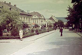
 Eger, the capital of the county
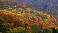 Autumn in the Bükk Mountains
_2.jpg) Keglevich Mansion in Pétervására
Keglevich Mansion in Pétervására_(5433._sz%C3%A1m%C3%BA_m%C5%B1eml%C3%A9k)_7.jpg) Romanesque church in Bélapátfalva
Romanesque church in Bélapátfalva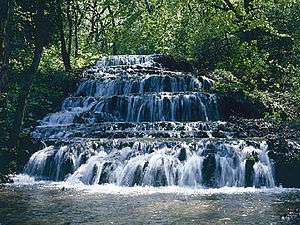 Waterfall in the Szalajka Valley near Szilvásvárad
%2C_Kossuth_Lajos_t%C3%A9r%2C_Hatvan3.jpg) Grassalkovich Mansion in Hatvan
Grassalkovich Mansion in Hatvan Lake Tisza is the 3rd largest lake of Hungary
_(5408._sz%C3%A1m%C3%BA_m%C5%B1eml%C3%A9k).jpg) Traditional residential house in Abasár
Traditional residential house in Abasár
International relations
Heves County has a partnership relationship with:[7][8]
|
|
References
| Wikimedia Commons has media related to Heves County. |
| Wikivoyage has a travel guide for Heves County. |
- ↑ nepesseg.com, population data of Hungarian settlements
- ↑ népesség.com, "Heves megye népessége 1870-2015"
- ↑ 1.1.6. A népesség anyanyelv, nemzetiség és nemek szerint – Frissítve: 2013.04.17.; Hungarian Central Statistical Office (in Hungarian)
- ↑ 2011. ÉVI NÉPSZÁMLÁLÁS, 3. Területi adatok, 3.10 Heves megye, (in Hungarian)
- ↑ Heves Megyei Közgyűlés tagjai és tisztségviselői, (in Hungarian)
- ↑ Önkormányzati választások eredményei (in Hungarian)
- ↑
- ↑
External links
| City with county rights |
|  |
|---|---|---|
| Towns | ||
| Large villages | ||
| Villages |
| |
| Other topics |
| |
Coordinates: 47°50′N 20°15′E / 47.833°N 20.250°E
| Authority control |
|---|