Baranya County
| Baranya County Baranya megye | |||
|---|---|---|---|
| Counties of Hungary | |||
   | |||
| |||
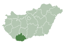 Baranya County within Hungary | |||
| Coordinates: 46°04′06″N 18°12′19″E / 46.06833°N 18.20528°ECoordinates: 46°04′06″N 18°12′19″E / 46.06833°N 18.20528°E | |||
| Country |
| ||
| Region | Southern Transdanubia | ||
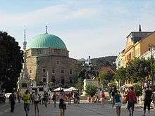
| County seat | Pécs | ||
| Districts | |||
| Government | |||
| • President of the General Assembly | Csaba Nagy (Fidesz-KDNP) | ||
| Area | |||
| • Total | 4,429.59 km2 (1,710.27 sq mi) | ||
| Area rank | 10th in Hungary | ||
| Population (2015) | |||
| • Total | 371,110[1] | ||
| • Rank | 10th in Hungary | ||
| Postal code | 73xx, 75xx – 79xx | ||
| Area code(s) | (+36) 69, 72, 73 | ||
| ISO 3166 code | HU-BA | ||
| Website |
baranya | ||

Baranya (Hungarian: Baranya megye, pronounced [ˈbɒrɒɲɒ]); is the name of an administrative county (comitatus or megye) in Hungary, in the Baranya region, and also in the former Kingdom of Hungary (see: Baranya (former county)).
The county lies in southern Hungary, on the border with Croatia. The River Drava forms part of its southern border, and the River Danube its eastern border. It shares borders with the Hungarian counties Somogy, Tolna, and Bács-Kiskun. The capital of Baranya county is Pécs.
Etymology
In German, it is known as Komitat Branau, and in Croatian as Baranjska županija (Baranja).
The county is name after the Slavic word 'bara', which means 'marsh', 'bog', thus the name of Baranya means 'marshland'. Even today large parts of the region are swamps, such as the natural reservation Kopački Rit in its southeast. Another theory states that the name of the region come from the Slavic and Hungarian word 'bárány', which means 'lamb'.
Geography
This county has a total area of 4,430 km2 (1,710 sq mi) – 4,76% of Hungary.
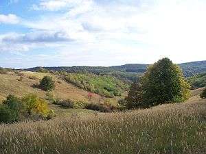
The northern part of the county is a mountain area with large forests, the Mecsek Mountains. The central areas are shared between the Baranya Hills and Villány Mountains. The very eastern and southern parts are flat.
The highest point in the county is Zengő in the Mecsek Mountains, at 682 metres. This is also the highest point of the mountain range.
The climate is Mediterranean, with a high number of sunshine hours. Baranya has the highest amount of rainfall in the country. Baranya is rich in mineral and thermal water, and also in other resources. 98% of Hungary's coal resources are found here.
Neighbours
- Tolna County in the North.
- Bács-Kiskun County in the East. (across the Danube river)

- Somogy County in the Northwest.
History
The area has been inhabited since ancient times. Before the Hungarian tribes conquered the area, it was inhabited by Slavs and Avars. Stephen I founded an episcopal seat here.
In 1526, the county was occupied by Ottomans and was freed in 1689. Its medieval borders remained unchanged until 1919. According to the peace treaty of Trianon, the southern part of the county (1163 km²) reverted to Slavic rule (present-day Croatia). The re-organizing of the counties (1950) brought only minor changes (town of Szigetvár got there).
Baranya has the largest number of minorities in Hungary (more than twice the country average), providing home to 34% of the German minority and 32% of the Southern Slav minorities in Hungary.
Electoral history
| Party | Votes | % | Seats | Change | |
|---|---|---|---|---|---|
| Fidesz-KDNP (joint) | 104,928 | 54,53 | 4 | - | |
| Hungarian Socialist Party | 40,532 | 21,07 | 1 | - | |
| Jobbik | 24,397 | 12,68 | 1 | - | |
| Politics Can Be Different | 7,119 | 8,9 | 0 | - | |
| Hungarian Democratic Forum | 5,436 | 2,83 | 0 | - | |
| Total | 182,412 | 100 | 6 | - |
Demographics
Religion in Baranya County (2011 census)
In 2015, it had a population of 371,110 and the population density was 84/km².
| Year | County population[2] | Change |
|---|---|---|
| 1949 | 356,533 | n/a |
| 1960 | 10.89% | |
| 1970 | 6.68% | |
| 1980 | 2.57% | |
| 1990 | -3.52% | |
| 2001 | -2.38% | |
| 2011 | -5.16% |
Ethnicity
Besides the Hungarian majority, the main minorities are the Germans (approx. 22,000), Roma (17,000), Croats (6,000), and Serbs (500).
Total population (2011 census): 386,441
Ethnic groups (2011 census):[3]
Identified themselves: 364,801 persons:
- Hungarians: 315,713 (86,54%)
- Germans: 22,150 (6,07%)
- Gypsies: 16,995 (4,66%)
- Croats: 6,343 (1,74%)
- Others and indefinable: 3,600 (0,99%)
Approx. 58,000 persons in Baranya County did not declare their ethnic group at the 2011 census.
Religion
Religious adherence in the county according to 2011 census:[4]
- Catholic – 181,933 (Roman Catholic – 180,749; Greek Catholic – 1,130);
- Reformed – 24,774;
- Evangelical – 4,601;
- Orthodox – 353;
- Other religions – 5,857;
- Non-religious – 62,613;
- Atheism – 5,824;
- Undeclared – 100,486.
Regional structure

| № | English and Hungarian names |
Area (km²) |
Population (2011) |
Density (pop./km²) |
Seat | № of municipalities |
| 1 | Bóly District Bólyi járás |
220.03 | 11,956 | 54 | Bóly | 16 |
| 2 | Hegyhát District Hegyháti járás |
360.72 | 12,744 | 35 | Sásd | 25 |
| 3 | Komló District Komlói járás |
292.48 | 35,489 | 121 | Komló | 20 |
| 4 | Mohács District Mohácsi járás |
600.98 | 35,164 | 59 | Mohács | 26 |
| 5 | Pécs District Pécsi járás |
623.07 | 189,036 | 303 | Pécs | 40 |
| 6 | Pécsvárad District Pécsváradi járás |
246.44 | 11,931 | 48 | Pécsvárad | 17 |
| 7 | Sellye District Sellyei járás |
493.69 | 14,192 | 29 | Sellye | 38 |
| 8 | Siklós District Siklósi járás |
652.99 | 35,929 | 55 | Siklós | 53 |
| 9 | Szentlőrinc District Szentlőrinci járás |
282.43 | 14,998 | 53 | Szentlőrinc | 21 |
| 10 | Szigetvár District Szigetvári járás |
656.76 | 25,002 | 38 | Szigetvár | 45 |
| Baranya County | 4,429.59 | 386,446 | 87 | Pécs | 301 | |
|---|---|---|---|---|---|---|
Politics
.jpg)
The Baranya County Council, elected at the 2014 local government elections, is made up of 19 counselors, with the following party composition:[5]
| Party | Seats | Current County Assembly | |||||||||||
|---|---|---|---|---|---|---|---|---|---|---|---|---|---|
| Fidesz-KDNP | 11 | ||||||||||||
| Movement for a Better Hungary (Jobbik) | 3 | ||||||||||||
| Hungarian Socialist Party (MSZP) | 3 | ||||||||||||
| Democratic Coalition (DK) | 1 | ||||||||||||
| Politics Can Be Different (LMP) | 1 | ||||||||||||
Presidents of the General Assembly
| List of Presidents, from 1990[6] | |
|---|---|
| Csaba Nagy (Fidesz-KDNP) | 2014– |
Municipalities[7][8]
Baranya County has 1 urban county, 13 towns, 3 large villages and 284 villages.

Like Borsod-Abaúj-Zemplén, Baranya is a county of extremes when it comes to regional structure. The county seat is one of the five largest cities (and three largest agglomerations) of Hungary, but more than 2/3 of the municipalities are small hamlets with a population under 500. Half of the county's population lives in the county seat or in its immediate vicinity, while 22% of the population lives in villages that have less than 1000 inhabitants.
- Cities with county rights
(ordered by population, as of 2011 census)
- Pécs (156,049) – county seat
- Towns
- Villages
- Abaliget
- Adorjás
- Almamellék
- Almáskeresztúr
- Alsómocsolád
- Alsószentmárton
- Apátvarasd
- Aranyosgadány
- Ág
- Áta
- Babarc
- Babarcszőlős
- Bakóca
- Bakonya
- Baksa
- Baranyahídvég
- Baranyajenő
- Baranyaszentgyörgy
- Basal
- Bánfa
- Bár
- Belvárdgyula
- Beremend

- Berkesd
- Besence
- Bezedek
- Bicsérd
- Bikal
- Birján
- Bisse
- Boda
- Bodolyabér
- Bogdása
- Bogád
- Bogádmindszent
- Boldogasszonyfa
- Borjád
- Bosta
- Botykapeterd
- Bükkösd
- Bürüs
- Csányoszró
- Csarnóta
- Csebény
- Cserdi
- Cserkút
- Csertő
- Csonkamindszent
- Cún
- Drávacsehi
- Drávacsepely
- Drávafok
- Drávaiványi
- Drávakeresztúr
- Drávapalkonya
- Drávapiski
- Drávaszabolcs
- Drávaszerdahely
- Drávasztára
- Dencsháza
- Dinnyeberki
- Diósviszló
- Dunaszekcső
- Egerág
- Egyházasharaszti
- Egyházaskozár
- Ellend
- Endrőc
- Erdősmecske
- Erdősmárok
- Erzsébet
- Fazekasboda
- Feked
- Felsőegerszeg
- Felsőszentmárton
- Garé
- Gerde
- Geresdlak
- Gerényes
- Gilvánfa
- Gordisa
- Gyód
- Gödre
- Görcsöny
- Görcsönydoboka
- Gyöngyfa
- Gyöngyösmellék
- Hásságy
- Hegyhátmaróc
- Hegyszentmárton
- Helesfa
- Hetvehely
- Hidas
- Himesháza
- Hirics
- Hobol
- Homorúd
- Horváthertelend
- Hosszúhetény
- Husztót
- Ibafa
- Illocska
- Ipacsfa
- Ivánbattyán
- Ivándárda
- Kacsóta
- Kákics
- Kárász
- Kásád
- Kátoly
- Katádfa
- Kékesd
- Kemse
- Keresztespuszta
- Keszü
- Kémes
- Képespuszta
- Kétújfalu
- Királyegyháza
- Kisasszonyfa
- Kisbeszterce
- Kisbudmér
- Kisdobsza
- Kisdér
- Kishajmás
- Kisharsány
- Kisherend
- Kisjakabfalva
- Kiskassa
- Kislippó
- Kisnyárád
- Kisszentmárton
- Kistamási
- Kistapolca
- Kistótfalu
- Kisvaszar
- Kisújbánya
- Kovácshida
- Kovácsszénája
- Kórós
- Köblény
- Kökény
- Kölked
- Kővágószőlős
- Kővágótöttös
- Lapáncsa
- Lánycsók
- Liget
- Lippó
- Liptód
- Lothárd
- Lovászhetény
- Lúzsok
- Magyarbóly
- Magyaregregy
- Magyarhertelend
- Magyarlukafa
- Magyarmecske
- Magyarsarlós
- Magyarszék
- Magyartelek
- Majs
- Markóc
- Márok
- Martonfa
- Maráza
- Marócsa
- Matty
- Mánfa
- Márfa
- Máriakéménd
- Máza
- Mecseknádasd
- Mecsekpölöske
- Mekényes
- Merenye
- Meződ
- Mindszentgodisa
- Molvány
- Monyoród
- Mozsgó
- Nagybudmér
- Nagycsány
- Nagydobsza
- Nagyhajmás
- Nagyharsány
- Nagykozár
- Nagynyárád
- Nagypall
- Nagypeterd
- Nagytótfalu
- Nagyváty
- Nemeske
- Nyugotszenterzsébet
- Okorvölgy
- Okorág
- Olasz
- Old
- Orfű
- Oroszló
- Óbánya
- Ócsárd
- Ófalu
- Ózdfalu
- Palkonya
- Palotabozsok
- Palé
- Páprád
- Patapoklosi
- Pécsbagota
- Pécsdevecser
- Pécsudvard
- Pellérd
- Pereked
- Peterd
- Pettend
- Piskó
- Pogány
- Pócsa
- Rádfalva
- Regenye
- Romonya
- Rózsafa
- Sámod
- Sárok
- Sátorhely
- Siklósbodony
- Siklósnagyfalu
- Somberek
- Somogyapáti
- Somogyhatvan
- Somogyhárságy
- Somogyviszló
- Sósvertike
- Sumony
- Szabadszentkirály
- Szajk
- Szalatnak
- Szalánta
- Szaporca
- Szava
- Szágy
- Szárász
- Szászvár
- Szebény
- Szederkény
- Székelyszabar
- Szellő
- Szemely
- Szentdénes
- Szentegát
- Szentkatalin
- Szentlászló
- Szilvás
- Szilágy
- Szörény
- Szőke
- Szőkéd
- Szulimán
- Szűr
- Tarrós
- Teklafalu
- Tengeri
- Tékes
- Tésenfa
- Téseny
- Tormás
- Tófű
- Tótszentgyörgy
- Töttös
- Túrony
- Udvar
- Újpetre
- Vajszló
- Varga
- Várad
- Vásárosbéc
- Vásárosdombó
- Vázsnok
- Vejti
- Vékény
- Velény
- Véménd
- Versend
- Villánykövesd
- Vokány
- Zaláta
- Zádor
- Zengővárkony
- Zók
![]()
Gallery
_19.jpg) Pécs, the capital of the county
Pécs, the capital of the county_2.jpg)
 Traditional house in Kisújbánya
.jpg) Town hall of Szigetvár
Town hall of Szigetvár Bell tower on the Mecsek Mountains
 Crystal caves in Nagyharsány
References
| Wikimedia Commons has media related to Baranya County. |
| Wikivoyage has a travel guide for Baranya County. |
- ↑ nepesseg.com, population data of Hungarian settlements
- ↑ népesség.com, "Baranya megye népessége 1870-2015"
- ↑ 1.1.6. A népesség anyanyelv, nemzetiség és nemek szerint – Frissítve: 2013.04.17.; Hungarian Central Statistical Office (in Hungarian)
- ↑ 2011. ÉVI NÉPSZÁMLÁLÁS, 3. Területi adatok, 3.3 Baranya megye, (in Hungarian)
- ↑ Képviselőtestület, (in Hungarian)
- ↑ Önkormányzati választások eredményei (in Hungarian)
- ↑ "Baranya (Hungary): County, Towns and Villages - Population Statistics in Maps and Charts". www.citypopulation.de. Retrieved 2016-08-04.
- ↑ Jimenez, Suzanne Somodi. "BARANYA County - Megye - Varmegye - Placenames". www.hungarianvillagefinder.com. Retrieved 2016-08-04.
External links
- Official site in Hungarian
- Dunántúli Napló (bama.hu) - The county portal
- Hungarian Central Statistics Office
| Authority control |
|---|