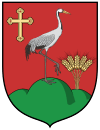
Daruszentmiklós
| Daruszentmiklós | ||
|---|---|---|
| ||
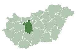
 Daruszentmiklós Location of Daruszentmiklós | ||
| Coordinates: 46°52′22″N 18°51′25″E / 46.872837°N 18.856866°E | ||
| Country |
| |
| County | Fejér | |
| Area | ||
| • Total | 19.28 km2 (7.44 sq mi) | |
| Population (2004) | ||
| • Total | 1,469 | |
| • Density | 76.19/km2 (197.3/sq mi) | |
| Time zone | UTC+1 (CET) | |
| • Summer (DST) | UTC+2 (CEST) | |
| Postal code | 2423 | |
| Area code(s) | 25 | |
| Website |
www | |
External links
- Street map (in Hungarian)
Coordinates: 46°52′06″N 18°51′45″E / 46.86841°N 18.86239°E
| Cities with county rights |
|   |
|---|---|---|
| Towns | ||
| Large villages | ||
| Villages |
| |
| Other topics |
| |
This article is issued from
Wikipedia.
The text is licensed under Creative Commons - Attribution - Sharealike.
Additional terms may apply for the media files.