List of extreme points of Mongolia
Here is a list of the extreme points and extreme elevations in Mongolia.[1]
Extreme points
| Heading | Location | Administrative entity | Bordering entity | Coordinates[nb 1] |
|---|---|---|---|---|
| North | across from the eastern border of Tuva to the northwest of the Darkhad valley. | Tsagaannuur, Khövsgöl | Tuva, Russia | 51°35′53″N 98°55′12″E / 51.597944°N 98.920103°E |
| South | In Gobi Small A National Park | Nomgon, Ömnögovi | Inner Mongolia, China | 38°50′00″N 105°39′59″E / 38.833411°N 105.666293°E |
| East | In Numrug National Park | Khalkhgol, Dornod Province | Inner Mongolia, China | 46°48′10″N 119°58′44″E / 46.802847°N 119.979018°E |
| West | In Altai Tavan Bogd National Park | Tsengel, Bayan-Ölgii | Xinjiang, China | 47°42′07″N 86°52′30″E / 47.70185°N 86.874897°E |
Extreme altitude
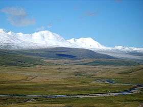
Khüiten Peak in Tsengel, Bayan-Ölgii is the highest peak in Mongolia. With a peak elevation of 4,374 metres (14,350 ft), it is part of the Altai Mountains range
| Extremity | Name | Altitude | Location | Province/Territory | Coordinates |
|---|---|---|---|---|---|
| Highest | Khüiten Peak | 4,374 m (14,350 ft) | Border between Bayan-Ölgii and Xinjiang | Bayan-Ölgii | 49°08′45″N 87°49′08″E / 49.145833°N 87.818889°E |
| Lowest | Near Sir Creek, Thatta | 518 m (1,699.5 ft) | Hoh Nuur, Choibalsan | Dornod Province | 49°29′56″N 115°34′34″E / 49.499°N 115.576°E |
See also
Notes
- ↑ Coordinates obtained from Google Earth. Google Earth makes use of the WGS84 geodetic reference system.
References
| Sovereign states |
|
|---|---|
| States with limited recognition |
|
| Dependencies and other territories |
|
| |
This article is issued from
Wikipedia.
The text is licensed under Creative Commons - Attribution - Sharealike.
Additional terms may apply for the media files.