East Tremont, Bronx
| East Tremont | |
|---|---|
| Neighborhood of the Bronx | |
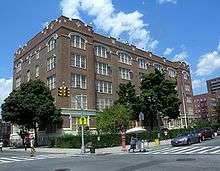
 Looking east across E182nd Street and Prospect Avenue | |
|
Location in New York City | |
| Coordinates: 40°50′46″N 73°53′31″W / 40.846°N 73.892°WCoordinates: 40°50′46″N 73°53′31″W / 40.846°N 73.892°W | |
| Country |
|
| State |
|
| City |
|
| Borough |
|
| Community District | Bronx 6[1] |
| Area[2] | |
| • Total | 1.13 km2 (0.436 sq mi) |
| Population (2010)[3] | |
| • Total | 43,423 |
| • Density | 38,000/km2 (100,000/sq mi) |
| Economics | |
| • Median income | $24,443 |
| ZIP codes | 10457, 10460 |
| Area code | 718, 347, 929, and 917 |
| Website |
www |

East Tremont is a residential neighborhood located in the West Bronx, New York City. It is part of Bronx Community Board 6. It borders, from the north and moving clockwise, East 180th Street, Crotona Avenue, the Cross-Bronx Expressway and Webster Avenue. East Tremont Avenue is the primary thoroughfare through the neighborhood. ZIP codes include 10457 and 10460. The area is patrolled by the NYPD's 48th Precinct[4] located at 450 Cross Bronx Expressway. New York City Housing Authority property in the area is patrolled by P.S.A. 8 at 2794 Randall Avenue in the Throggs Neck section of the Bronx.
Demographics
Based on data from the 2010 United States Census, the population of East Tremont was 43,423, an increase of 4,143 (10.5%) from the 39,280 counted in 2000. Covering an area of 445.31 acres (180.21 ha), the neighborhood had a population density of 97.5 inhabitants per acre (62,400/sq mi; 24,100/km2).[3]
The racial makeup of the neighborhood was 1.4% (627) White, 29.4% (12,750) African American, 0.3% (110) Native American, 0.5% (229) Asian, 0.0% (4) Pacific Islander, 0.3% (150) from other races, and 0.8% (333) from two or more races. Hispanic or Latino of any race were 67.3% (29,220) of the population.[5]
The neighborhood predominately consists of Latin Americans (East Tremont has one of the highest concentrations of Puerto Ricans in New York City) and African Americans. There is a small but growing Dominican population. Almost half the population lives below the poverty line and receives public assistance (AFDC, Home Relief, Supplemental Security Income, and Medicaid). Most households are renter occupied.[6]
Land use and terrain
East Tremont is dominated by five and six story tenement buildings, older multi-unit homes, vacant lots, and newly constructed apartment buildings. Most of the original housing stock was structurally damaged by arson and eventually razed by the city. The land area, somewhat hilly, is less than one square mile.
There are two NYCHA developments located in East Tremont.[7]
- Twin roads East (Site 9); one, 14-story building.
- East 180th Street-Monterey Avenue; one, 10-story building.
Education
All are public schools.
- PS/MS 3: Raul Julia (East 180th St and LaFontaine Av)
- PS 23: Early Childhood (East 181st St and Washington Av)
- PS 32: Belmont (East 183rd St and Belmont Av)
- PS 44: David Farragut (East 176th St and Prospect Av)
- PS 57: Crescent/Frederick Douglass Academy V (East 180th St and Crotona Av)
- PS 58: Tremont Park (East 176th St and Washington Av)
- PS 59: Bathgate (East 182nd St and Bathgate Av)
- PS 92: (East 179th St and Clinton Av)
- PS/MS 211: The Bilingual School (Fairmount Place and Prospect Av)
- PS 300/MS 129/P10/IS 316: Twin Parks (East 180th St and Mapes Av)
- MS 118: William J. Niles (East 179th St and Arthur Av)
- MS/HS 231: Eagle Academy for Young Men (East 176th St and 3rd Av)
Transportation
There are no New York City Subway stations in East Tremont, though several bus routes connect with subway stations. The following MTA Regional Bus Operations bus routes serve East Tremont:[8]
- Bx15: to Fordham Plaza or West Harlem (via Third Avenue)
- Bx17: to Fordham Plaza or Port Morris (via Crotona and Prospect Avenues)
- Bx19: to New York Botanical Gardens or Riverbank State Park (via Southern Boulevard/East 149th Street)
- Bx36: to Castle Hill or George Washington Bridge Bus Terminal (via East 180th Street)
- Bx40: to SUNY Maritime College or Morris Heights (via Tremont and Burnside Avenues)
- Bx41: to Gun Hill Road station or Third Avenue – 149th Street station (via Webster Avenue)
- Bx42: to Throggs Neck or Morris Heights (via Tremont and Burnside Avenues)
The Metro-North Railroad's Harlem Line also serves East Tremont at the Tremont station.
References
![]()
- ↑ "NYC Planning | Community Profiles". communityprofiles.planning.nyc.gov. New York City Department of City Planning. Retrieved 4 March 2018.
- ↑ "East Tremont neighborhood in New York". Retrieved 19 October 2015.
- 1 2 Table PL-P5 NTA: Total Population and Persons Per Acre - New York City Neighborhood Tabulation Areas*, 2010, Population Division - New York City Department of City Planning, February 2012. Accessed June 16, 2016.
- ↑ "48th Precinct". Retrieved 19 October 2015.
- ↑ Table PL-P3A NTA: Total Population by Mutually Exclusive Race and Hispanic Origin - New York City Neighborhood Tabulation Areas*, 2010, Population Division - New York City Department of City Planning, March 29, 2011. Accessed June 14, 2016.
- ↑ Bronx Community District 6
- ↑ NYCHA Archived May 25, 2015, at the Wayback Machine.
- ↑ "Bronx Bus Map" (PDF). Metropolitan Transportation Authority. September 2017. Retrieved April 24, 2018.
| South Bronx |  | |
|---|---|---|
| West Bronx | ||
| East Bronx | ||
| Related areas |
| |