Rajmahal hills
| Rajmahal Hills | |
|---|---|
| Hills | |
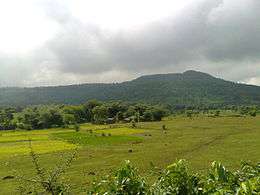 View of Rajmahal Hills | |
| Country |
|
| State | Jharkhand |
| Languages | |
| • Official | Hindi, Santali |
| Time zone | UTC+5:30 (IST) |
| Vehicle registration | JH |
The Rajmahal Hills are located in the Santhal Pargana division of Jharkhand, India. They were located on the northern margin of the Gondwana supercontinent, and its hills are today inhabited by the Sauria Paharia people whilst its valleys are dominated by the Santhal people.[1] The hills span over an area of 2,600 km2 (1,000 sq mi).[2]
Volcanic activity in the Jurassic resulted in the formation of the Rajmahal Traps. The hills are approximately located at 25°N 87°E / 25°N 87°ECoordinates: 25°N 87°E / 25°N 87°E[3]
The Rajmahal hills are named after the town of Rajmahal which lies in the eastern Jharkhand. The hills trend north-south with an average elevation of 200–300 m (660–980 ft), from the Sahibganj district to the Dumka district. The River Ganges wanders around the hills changing the direction of flow from east to south.
Fossils
The Rajmahal hills are home to plant fossils which are 68 to 145 million years old. The Birbal Sahni Institute of Palaeobotany in Lucknow has an impressive collection of these fossils. The fossils here have attracted geologists and palaeobotanists from all over the world. There are fears of these fossils disappearing now, as the state government has in 2018 given out a mining lease in the area to private companies.[2]
References
- ↑ "Rajmahal natives seek autonomous council". The Telegraph India. 13 February 2012. Retrieved 30 December 2017.
- 1 2 "Rare fossils in India threatened". BBC News. 25 July 2008.
- ↑ Khan, Mujibur Rahman (2012). "Rajmahal Hills". In Islam, Sirajul; Jamal, Ahmed A. Banglapedia: National Encyclopedia of Bangladesh (Second ed.). Asiatic Society of Bangladesh.