Shkumbin
| Shkumbin | |
|---|---|
 | |
| Country | Albania |
| Physical characteristics | |
| Main source |
Valamara Korçë County 2,120 m (6,960 ft) 40°47′57″N 20°18′14″E / 40.79917°N 20.30389°E |
| River mouth |
18 km (11 mi) west of Rrogozhinë Adriatic Sea 0 m (0 ft) 41°2′23″N 19°26′34″E / 41.03972°N 19.44278°ECoordinates: 41°2′23″N 19°26′34″E / 41.03972°N 19.44278°E |
| Length | 181 km (112 mi)[1] |
| Basin features | |
| Basin size | 2,444 km2 (944 sq mi)[2][3] |
The Shkumbin (/ʃkuːmbiːn/; Albanian pronunciation: [ʃkumbin]; Latin: Genessus), also commonly Shkembi, is a river in Southern and Southeastern Europe.[4] The river originates in the eastern Valamara Mountains between Maja e Valamarës (2,375 m (7,792 ft)) and Gur i Topit (2,120 m (6,960 ft)) in Southeastern Albania.[5]
After descending from the Valamara's, it flows northwards through Proptisht and Qukës with many deep gorges and canyons and passes the Gora Mountains. A significant inflow comes from Gur i Kamjës (1,481 m (4,859 ft)) southwest of Pogradec. Over the course, it flows inside a syncline between the Mokra and Shebenik Mountains in the east and the Polis Mountains in the west. Close to Librazhd the river turns some 50 km (31 mi) westwards of its origin and joins the Rapun stream.[6] At the end the river cross the Myzeqe Plain and forms a small delta in Karavasta Lagoon, the direct proximity of the Adriatic Sea.
Historically, the river is considered to be the dividing line between the Tosk and Gheg dialects. Furthermore, the ancient Via Egnatia followed the river, giving the river the role of a strategically important corridor between orient and occident.[7] On various historical periods it was considered the northernmost natural boundary of Epirus,[8] while during the 5th and 6th centuries it was the cultural border between the Illyrian and the Greek world.[9]
 Hydrographic map of Albania: Shkumbin is shown in the center of the map. |
.jpg) Origin of the river at Valamara |
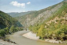
.JPG) Shkumbin Valley about 5 km east of Elbasan |
See also
| Wikimedia Commons has media related to Shkumbin. |
References
- ↑ "TREGUES SIPAS QARQEVE INDICATORS BY PREFECTURES" (PDF). Archived from the original (PDF) on 2011-07-24. Retrieved 2012-11-02.
- ↑ "The coastline of Albania : morphology, evolution and coastal management issues" (PDF). ciesm.org. p. 8.
- ↑ "Fishes from Shkumbini River (Central Albania): an ecological view". researchgate.net. p. 1.
- ↑ Robert Elsie. p. 459.
- ↑ University of Tirana. "Albert-Kurti-compressed.pdf" (PDF). doktoratura.unitir.edu.al (in Albanian). Tirana. p. 43.
- ↑ "KREU I: PASURITË UJORE SHQIPTARE" (PDF) (in Albanian). p. 19.
- ↑ University of Tirana. "MALLAKASTRA STUDIM GJEOGRAFIK" (PDF). doktoratura.unitir.edu.al (in Albanian). p. 21.
- ↑ Mikropoulos A. Tassos.Elevating and Safeguarding Culture Using Tools of the Information Society: Dusty traces of the Muslim culture. Earthlab. ISBN 978-960-233-187-3, p. 320: "Therefore the river referred to as Gennousos in ancient sources... again became a natural border in the north of Epirus"
- ↑ Nicholas Geoffrey Lemprière Hammond. Migrations and invasions in Greece and adjacent areas. Noyes Press, 1976. ISBN 978-0-8155-5047-1. p. 54: "The line of division between Illyricum and the Greek area, 'Epirus Nova', in terms of Roman provincial administration ran somewhere between Scodra and Dyrrachium and then eastwards on the north side of the Shkumbi and Lake Ochrid"