Dessie
| Dessie ደሴ (in Amharic) | ||
|---|---|---|
| Town | ||
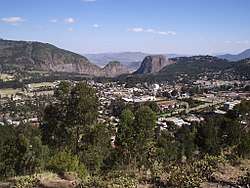 View of Dessie | ||
| ||
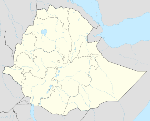 Dessie Location in Ethiopia | ||
| Coordinates: 11°8′N 39°38′E / 11.133°N 39.633°ECoordinates: 11°8′N 39°38′E / 11.133°N 39.633°E | ||
| Country |
| |
| Region | Amhara | |
| Zone | Dessie City | |
| Government | ||
| • Mayor (ከንቲባ) | Alebachew Yesuf | |
| Area | ||
| • Total | 15.08 km2 (5.82 sq mi) | |
| Elevation | 2,470 m (8,100 ft) | |
| Population (2012) | ||
| • Total | 610,431 | |
| • Density | 40,000/km2 (100,000/sq mi) | |
| Time zone | UTC+3 (EAT) | |
| Area code(s) | 33 | |
Dessie (Amharic: ደሴ) (also spelled Dese or Dessye), is a city and a Zone in north-central Ethiopia. Located in the Amhara Region, it sits at a latitude and longitude of 11°8′N 39°38′E / 11.133°N 39.633°E, with an elevation between 2,470 and 2,550 metres above sea level.
History
16th-17th Century
Prior to Dessie's foundation, the major settlement in this area was Wasal, first mentioned in an early 16th-century Italian itinerary.[1]
19th Century
Emperor Yohannes IV was camping in the highlands to the west of the Chefa Valley in 1882 on an expedition to forecefully convert the Muslim Wollo who lived in the region to Christianity. As he was looking for a place to centralize his power in the newly conquered region of Wollo, he stayed overnight in a pre-existing town that is now contained within Dessie. While there, he spotted a comet. He was so impressed by the sight of it that he interpreted it to be a sign from heaven to found his capital city there. Thus, he named it Dessie (Amharic "My Joy"), as a reference to the elation that the comet had made him feel.[2]
20th Century
Dessie's location led to the telegraph line the Italians constructed between 1902 and 1904 from Asmara south to Addis Ababa passing through the city, and giving it a local telegraph office. Also in 1904, the Italian Giuseppe Bonaiuti took part in constructing a fair-weather road connecting the city to Addis Ababa.[2]
Dessie increased in importance when Ras Mikael Ali, son-in-law to Emperor Menelik II, made it his base. The city was where his son, would-be emperor Iyasus V, crowned Mikael negus around 1915. During his residence in Dessie, the Negus built a palace and the church Enda Medhane Alem, said to be placed on the site of a church destroyed by Imam Ahmed Gragn. The church is decorated with paintings which include portraits of Ras Mikael and his son.[2]
After the defeat of his father Negus Mikael, Lij Iyasu took refuge in Dessie beginning on 8 November 1916 while unsuccessfully seeking support from Ras Wolde Giyorgis and other major nobles of northern Ethiopia. However, Ras Wolde Giyorgis used these overtures to extract concessions from the central government, then marched on Dessie which Lij Iyasu fled 10 December.[3]
During the Italian invasion, Dessie was first bombed 6 December 1935; the American Hospital was one of the buildings damaged in the attack. Emperor Haile Selassie was photographed personally machine-gunning the raiding planes. The city was occupied by the Italians 15 April 1936.[2]
Dessie became an important administrative center under the Italian occupation, and the Franciscans established in 1937 the Latin Catholic missionary Apostolic Prefecture of Dessié, which would be suppressed in 1957 after its only prefect's death.
The Italian garrison of the city surrendered 26 April 1941 to Brigadier Pienaar's 1st South African Brigade and 500 arbegnoch,[2] and after the Second World War, the town continued in importance as the capital of the province of Wollo until the province's abolition in 1995.
In a decree of 1942, Dessie is listed as one of only six "Schedule A" municipalities in Ethiopia, while there were about a hundred in "Schedule B". Artist Essaye Gebre-Medhin Fikre was born in Dessie in 1949. He gained a B.A. in Addis Ababa and an M.A. in Paris but was self-taught as an artist. In 1955, a public address system was installed in the central square which was used to re-broadcast announcements on Radio Addis Ababa to the public. In 1957, Dessie had one of 9 provincial secondary schools (excluding Eritrea) in Ethiopia, named after Woizero Sehine the daughter of Negus Mikael.[2]
In February 1973, a crowd of 1,500 peasants marched from Dessie to the capital to make the authorities notice the famine in Wollo. They were stopped by police on the outskirts of Addis Ababa and forced to return. Following the Ethiopian revolution, one of the few major encounters between rebels and government forces took place north-west of Dessie in October 1976. Instigated by the local landlord, a large group of peasants marched on the city; troops of the Derg fired into the crowd. Reports of the death toll vary widely, from several hundred to nearly a thousand. In October 1989 Dessie was almost captured by the Ethiopian People's Revolutionary Democratic Front (EPRDF).[2] The EPRDF took permanent control of the city on 18 May 1990, as part of Operation Wallelign.[4]
Cityscape
Dessie is home to a museum, in the former home of Dejazmach Yoseph Birru. It also has a zawiya of the Qadiriyya order of Islam, which was the first Sufi order to be introduced into north-east Africa.[2]
Demographics
Based on the 2007 national census conducted by the Central Statistical Agency of Ethiopia (CSA), Dessie woreda has a total population of 151,174, of whom 72,932 are men and 78,242 women; 120,095 or 79.44% are urban inhabitants living in the town of Dessie, the rest of the population is living at rural kebeles around Dessie. The majority of the inhabitants were Muslim, with 58.62% reporting that as their religion, while 39.92% of the population said they practiced Ethiopian Orthodox Christianity and 1.15% were Protestants.[5]
The 1994 national census reported a total population for Dessie of 97,314 in 17,426 households, of whom 45,337 were men and 51,977 were women. The two largest ethnic groups reported in this town were the Amhara (92.83%) and the Tigrayan (4.49%); all other ethnic groups made up 2.68% of the population.
Amharic was spoken as a first language by 94.89% and 3.79% spoke Tigrinya; the remaining 0.67% spoke all other primary languages reported.
Religion
The 2007 national census reported 59% of the inhabitants professed Islam with 41% of the population having reported they practiced Christianity.[7]
The 1994 national census reported 63% of the inhabitants professed Ethiopian Orthodox Christianity with 37% of the population having reported they practiced Islam.[8]
The small Eastern Catholic minority is part of the Ethiopian Catholic Eparchy of Bahir Dar–Dessie.
Economy
Dessie is located along Ethiopian Highway 2. It has postal service (a post office was established in the 1920s), and telephone service from at least as early as 1954. The city has had electrical power since at least 1963 when a new diesel-powered electric power station with a power line to Kombolcha was completed, at a cost of Eth$ 110,000.[2] Intercity bus service is provided by the Selam Bus Line Share Company. Dessie shares Combolcha Airport (ICAO code HADC, IATA DSE) with neighbouring Kombolcha.
Climate
Dessie is a good location, beautiful scenery, and good air, located at an altitude of 2,470 meters above sea level in low-shrouded mountains and hills" and the surrounding mountains.[9]
| Climate data for Dessie | |||||||||||||
|---|---|---|---|---|---|---|---|---|---|---|---|---|---|
| Month | Jan | Feb | Mar | Apr | May | Jun | Jul | Aug | Sep | Oct | Nov | Dec | Year |
| Average high °C (°F) | 22.7 (72.9) |
23.1 (73.6) |
22.4 (72.3) |
23.4 (74.1) |
24.5 (76.1) |
25.3 (77.5) |
24.1 (75.4) |
23.0 (73.4) |
22.2 (72) |
22.6 (72.7) |
21.7 (71.1) |
22.0 (71.6) |
23.1 (73.6) |
| Average low °C (°F) | 5.4 (41.7) |
7.1 (44.8) |
6.9 (44.4) |
8.4 (47.1) |
8.1 (46.6) |
9 (48) |
10.3 (50.5) |
10 (50) |
9.2 (48.6) |
6.3 (43.3) |
4.1 (39.4) |
4.1 (39.4) |
7.4 (45.3) |
| Average precipitation mm (inches) | 25 (0.98) |
40 (1.57) |
81 (3.19) |
95 (3.74) |
75 (2.95) |
41 (1.61) |
273 (10.75) |
283 (11.14) |
144 (5.67) |
45 (1.77) |
20 (0.79) |
23 (0.91) |
1,145 (45.07) |
| Source: Climate-Data.org, altitude: 2,470m[9] | |||||||||||||
Famous locals
- Yekuno Amlak, founder of the Solomonic dynasty of Ethiopian emperors.
- Mohammed Al Amoudi, the second-richest person of Black African descent in the world.
Culture
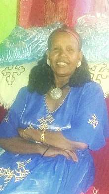
Dessie is known to be apart of the Wollo culture, thus having a style of cultural clothing, as well as significant dances. Men's traditional clothing is similar to the Ormo region of Ethiopia, having pants and a loose shirt, and wearing a scarf around the head. Women's traditional clothing includes a Habesha kemis, which is the name of the dress, as well as a matching scarf, sometimes two, one tied around the waist and the other over the hair.
References
- ↑ O.G.S. Crawford, Ethiopian Itineraries, circa 1400-1524 (Cambridge: Hakluyt Society, 1958), pp. 50-52.
- 1 2 3 4 5 6 7 8 9 "Local History in Ethiopia" (pdf) The Nordic Africa Institute website (accessed 2 February 2008)
- ↑ Harold Marcus, Haile Sellassie I: The Formative Years 1892-1935 (Lawrenceville: Red Sea Press, 1996), pp. 25f
- ↑ Gebru Tareke, The Ethiopian Revolution: War in the Horn of Africa (New Haven: Yale University, 2009), p. 306
- ↑ Census 2007 Tables: Amhara Region, Tables 2.1, 2.4, 2.5, 3.1, 3.2 and 3.4.
- ↑ Central Statistical Agency. 2010. Population and Housing Census 2007 Report, National. [ONLINE] Available at: http://catalog.ihsn.org/index.php/catalog/3583/download/50086. [Accessed 10 January 2017].
- ↑ Census 2007 Tables: Amhara Region, Tables 2.1, 2.4, 2.5, 3.1, 3.2 and 3.4.
- ↑ 1994 Population and Housing Census of Ethiopia: Results for Amhara Region, Vol. 1, part 1 Archived November 15, 2010, at the Wayback Machine., Tables 2.1, 2.7, 2.10, 2.13, 2.17, Annex II.2 (accessed 9 April 2009)
- 1 2 "Climate: Dessie - Climate graph, Temperature graph, Climate table". Climate-Data.org. Retrieved 25 September 2016.
External links
![]()