Asmara
Asmara
| ||
|---|---|---|
| Capital | ||
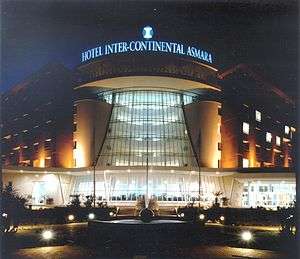
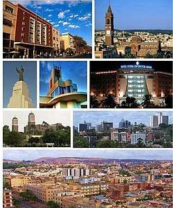 A collage of Asmara’s sights (from left to right) 1st Row: Cinema Impero, St. Joseph’s Cathedral 2nd Row: San Francesco d'Assisi Monument, Fiat Tagliero Building, Hotel Intercontinental Asmara 3rd Row : Enda Mariam Cathedral, Skyline of Asmara 4th Row : View of Asmara from St. Joseph’s Cathedral | ||
| ||
| Nickname(s): Little Rome | ||
| Coordinates: 15°19′22″N 38°55′30″E / 15.32278°N 38.92500°ECoordinates: 15°19′22″N 38°55′30″E / 15.32278°N 38.92500°E | ||
| Country |
| |
| Zoba | Maekel | |
| Districts | 13 | |
| Demonym | Asmarino | |
| Established | 1890 | |
| Government | ||
| • Mayor of Asmara | Tewelde Kelati | |
| • Mayor of Zoba | Major General Osman Awliya | |
| Area | ||
| • Capital | 45 km2 (17 sq mi) | |
| Elevation | 2,325 m (7,628 ft) | |
| Population (2017)[1] | ||
| • Capital | 804,000 | |
| • Density | 17,867/km2 (46,280/sq mi) | |
| • Metro | 1,258,001 | |
| Time zone | UTC+3 (EAT) | |
| Climate | BSk | |
| UNESCO World Heritage site | ||
| Official name | Asmara: a Modernist City of Africa | |
| Criteria | Cultural: ii, iv | |
| Reference | 1550 | |
| Inscription | 2017 (41st Session) | |
| Area | 481 ha | |
| Buffer zone | 1,203 ha | |
Asmara (Arabic: أسمرة) (Tigrinya: ኣስመራ), or Asmera (meaning “They made them unite” in Tigrinya), is the capital and most populous city of Eritrea. It sits at an elevation of 2,325 metres (7,628 ft), making it the sixth highest capital in the world by altitude. The city is located at the tip of an escarpment that is both the northwestern edge of the Eritrean highlands and the Great Rift Valley in neighbouring Ethiopia. In 2017, the city was declared as a UNESCO World Heritage Site.[2]
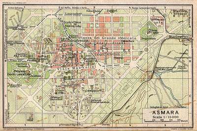
Asmara is situated in Eritrea's central Maekel Region. It is known for its well-preserved colonial Italian modernist architecture.[3] The city is divided into thirteen districts or administrative areas: Acria, Abbashaul, Edaga Hamus, Arbaete Asmara, Mai Temenai, Paradizo, Sembel, Godaif, Maekel Ketema or Downtown, Tiravolo, Gejeret, Tsetserat and Gheza Banda.
History
Originally, according to Eritrean Tigrinya oral traditional history, there were four clans living in the Asmara area on the Kebessa Plateau: the Gheza Gurtom, the Gheza Shelele, the Gheza Serenser and Gheza Asmae. These towns were frequently attacked by clans from the low land and from the rulers of "seger mereb melash" (which now is a Tigray region in Ethiopia), until the women of each clan decided that to defeat their common enemy and preserve peace the four clans must unite. The men accepted, hence the name "Arbate Asmera". Arbate Asmara literally means, in the Tigrinya language, "the four (feminine plural) made them unite".[4] Eventually Arbate was dropped and it has been called Asmara which means "they [feminine, thus referring to the women] made them unite". There is still a district called Arbaete Asmara in the Administrations of Asmara. It is now called the Italianized version of the word Asmara. The westernized version of the name is used by a majority of non-Eritreans, while the multilingual inhabitants of Eritrea and neighboring peoples remain loyal to the original pronunciation, Asmera.
The missionary Remedius Prutky passed through Asmara in 1751, and described in his memoirs that a church built there by Jesuit priests 130 years before was still intact.[5]
Italian Asmara
Asmara -a small village in the nineteenth century- started to grow quickly when it was occupied by Italy in 1889[6]. Governor Ferdinando Martini made it the capital city of Italian Eritrea in 1897, in preference to the Red Sea port of Massawa, and since then the city experienced a continuous growth.
In the early 20th century, the Eritrean Railway was built to the coast, passing through the town of Ghinda, under the direction of Carlo Cavanna. In both 1913 and 1915 the city suffered only slight damage in large earthquakes.[7]
A large Italian community developed. According to the 1939 census, Asmara had a population of 98,000, of which 53,000 were Italian. Only 75,000 Italians lived in all of Eritrea, making the capital city by far their largest centre.[8] (Compare this to the Italian colonization of Libya, where the settler population, albeit larger, was more dispersed.)
The capital acquired an Italian architectural look. Europeans used Asmara "to experiment with radical new designs".[9] By the late 1930s, Asmara was called Piccola Roma (Little Rome).[10] Nowadays more than 400 buildings are of Italian origin, and many shops still have Italian names (e.g., Bar Vittoria, Pasticceria moderna, Casa del formaggio, and Ferramenta).
The Kingdom of Italy invested in the industrial development of Asmara (and surrounding areas of Eritrea)[11], but the beginning of World War II stopped this.
The United Nations Educational, Scientific and Cultural Organisation made Asmara a World Heritage Site in July 2017, saying “It is an exceptional example of early modernist urbanism at the beginning of the 20th century and its application in an African context”.[12]
Federation with Ethiopia
In 1952, the United Nations resolved to federate the former colony under Ethiopian rule. During the Federation, Asmara was no longer the capital city. The capital was now Addis Ababa, over 1,000 kilometres (620 miles) to the south. The national language of the city was therefore replaced from Tigrinya language to the Ethiopian Amharic language. In 1961, Emperor Haile Selassie I ended the "federal" arrangement and declared the territory to be the 14th province of the Ethiopian Empire.[13] Ethiopia's biggest ally was the United States. The city was home to the US Army's Kagnew Station installation from 1943 until 1977. The Eritrean War of Independence began in 1961 and ended in 1991, resulting in the independence of Eritrea. Asmara was left relatively undamaged throughout the war, as were the majority of highland regions. After independence, Asmara again became the capital of Eritrea.
Religion
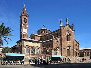
Four big landmarks of the city are the Church of Our Lady of the Rosary and the Kidane Mehret Cathedral of the Catholic faith, the Enda Mariam Cathedral of the Eritrean Orthodox Tewahedo Church, and the Al Khulafa Al Rashiudin Mosque of the Islamic faith. Christians and Muslims have lived peacefully together in Asmara for centuries. The religious majority in Asmara are Orthodox Christians. The population in the Central Region is 89 percent Christian (almost 84 percent Orthodox, 4 percent Roman Catholic, and more than 1 percent Protestant) and 5 percent Muslim.[14]
Geography
The city lies at an elevation of 2,325 metres (7,628 feet) above sea level. It lies on north-south trending highlands known as the Eritrean Highlands, an extension of the Ethiopian Highlands. The temperate central portion, where Asmara lies, is situated on a rocky highland plateau, which separates the western lowlands from the eastern coastal plains. The lands that surround Asmara are very fertile, especially those to the south towards the Debub Region of Eritrea. The highlands that Asmara is located in fall away to reveal the eastern lowlands, characterized by the searing heat and humidity of the Eritrean salt pans, lapped by the Red Sea. To the west of the plateau stretches a vast semi-arid hilly terrain continuing all the way towards the border with Sudan through the Gash-Barka Region.
Climate
Asmara features a somewhat rare version of a steppe climate, with warm, but not hot summers and mild winters. Asmara's climate can also be considered arid to semi-arid.[15] Due to its 2,325-metre (7,630 ft) altitude, temperatures are relatively mild for a city located not particularly far from deserts. This climate is characteristic of rainy, wet seasons and dry seasons.[16] Asmara averages about 500 millimetres (20 in) of precipitation annually. Frost, however, is extremely rare in the city. The long rainy season of the year extends from June until September. The short rainy season occurs from March until April.[16] On average, about 60% of Asmara’s annual precipitation is seen during the months of July and August. In contrast, December to February are typically Asmara’s driest months, where on average only 8 millimetres (0.31 in) of precipitation falls in the three months combined. Due to variable rainfall, Asmara’s climate is also characterized by drought.[17] Several prolonged droughts in this region have occurred beginning in the 1960s and have recurred each decade since then.[17] During periods of drought, temperatures are high and little rainfall occurs. As temperatures of a region increase, the rate of evaporation of water from the soil also increases. These combined processes result in the desertification of the soil. In order to obtain nutrient rich and moist soil for farming purposes, populations rely on deforestation to make use of the underlying ground.[17] The most serious environmental issues Asmara faces are deforestation and desertification. Other issues Asmara faces are soil erosion and overgrazing. All of these environmental issues produce soil degradation.[17]
| Climate data for Asmara (1961–1990, extremes 1903–2012) | |||||||||||||
|---|---|---|---|---|---|---|---|---|---|---|---|---|---|
| Month | Jan | Feb | Mar | Apr | May | Jun | Jul | Aug | Sep | Oct | Nov | Dec | Year |
| Record high °C (°F) | 29.0 (84.2) |
29.2 (84.6) |
30.5 (86.9) |
31.0 (87.8) |
30.0 (86) |
29.4 (84.9) |
29.4 (84.9) |
27.4 (81.3) |
27.2 (81) |
31.0 (87.8) |
26.7 (80.1) |
26.2 (79.2) |
31.0 (87.8) |
| Average high °C (°F) | 22.3 (72.1) |
23.8 (74.8) |
25.1 (77.2) |
25.1 (77.2) |
25.0 (77) |
24.9 (76.8) |
21.6 (70.9) |
21.5 (70.7) |
22.9 (73.2) |
21.7 (71.1) |
21.5 (70.7) |
21.5 (70.7) |
23.1 (73.6) |
| Daily mean °C (°F) | 13.8 (56.8) |
14.9 (58.8) |
16.3 (61.3) |
17.0 (62.6) |
17.6 (63.7) |
17.6 (63.7) |
16.3 (61.3) |
16.1 (61) |
15.7 (60.3) |
14.9 (58.8) |
14.0 (57.2) |
13.2 (55.8) |
15.6 (60.1) |
| Average low °C (°F) | 4.3 (39.7) |
5.1 (41.2) |
7.5 (45.5) |
8.7 (47.7) |
10.2 (50.4) |
10.5 (50.9) |
10.8 (51.4) |
10.7 (51.3) |
8.6 (47.5) |
8.1 (46.6) |
6.6 (43.9) |
4.8 (40.6) |
8.0 (46.4) |
| Record low °C (°F) | −4.5 (23.9) |
−1.6 (29.1) |
−0.8 (30.6) |
−0.2 (31.6) |
2.0 (35.6) |
3.4 (38.1) |
3.9 (39) |
3.7 (38.7) |
0.2 (32.4) |
1.0 (33.8) |
−0.5 (31.1) |
−1.4 (29.5) |
−4.5 (23.9) |
| Average rainfall mm (inches) | 3.7 (0.146) |
2.0 (0.079) |
14.6 (0.575) |
33.4 (1.315) |
41.1 (1.618) |
38.5 (1.516) |
174.9 (6.886) |
155.6 (6.126) |
15.6 (0.614) |
15.4 (0.606) |
20.4 (0.803) |
3.4 (0.134) |
518.6 (20.418) |
| Average rainy days (≥ 1.0 mm) | 0 | 0 | 2 | 4 | 5 | 4 | 13 | 12 | 2 | 2 | 2 | 1 | 47 |
| Average relative humidity (%) | 54 | 48 | 46 | 49 | 48 | 48 | 76 | 80 | 59 | 63 | 66 | 61 | 58.2 |
| Mean monthly sunshine hours | 291.4 | 260.4 | 275.9 | 264.0 | 257.3 | 219.0 | 151.9 | 158.1 | 213.0 | 272.8 | 276.0 | 282.1 | 2,921.9 |
| Mean daily sunshine hours | 9.4 | 9.3 | 8.9 | 8.8 | 8.3 | 7.3 | 4.9 | 5.1 | 7.1 | 8.8 | 9.2 | 9.1 | 8 |
| Source #1: NOAA[18] | |||||||||||||
| Source #2: Meteo Climat (record highs and lows)[19] | |||||||||||||
Features
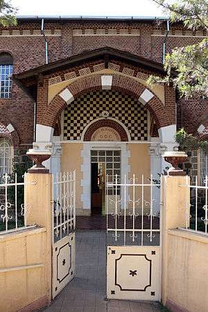
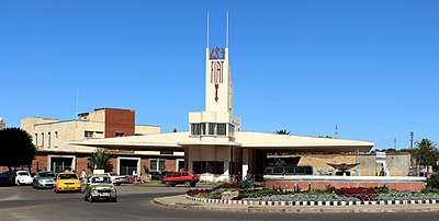
The city is home to the Eritrean National Museum and is known for its early 20th-century buildings, including the Art Deco Cinema Impero (opened in 1937 and considered by the experts one of the world's finest examples of Art Déco style building[20]), Cubist Africa Pension, eclectic Orthodox Cathedral and former Opera House, the futurist Fiat Tagliero Building, the neo-Romanesque Church of Our Lady of the Rosary, Asmara, and the neoclassical Governor's Palace. The city is adorned by Italian colonial villas and mansions, one prominent example being the World Bank Building. Most of central Asmara was built between 1935 and 1941, so the Italians effectively managed to build almost an entire city in just six years.[21] At this time, the dictator Benito Mussolini had great plans for a second Roman Empire in Africa. War cut this short, but his injection of funds created the Asmara of today, which supposedly was to be a symbol that Fascism worked and is an ideal system of government.
The city shows off most early 20th-century architectural styles. Some buildings are neo-Romanesque, such as the Church of Our Lady of the Rosary, some villas are built in a late Victorian style. Art Deco influences are found throughout the city. Essences of Cubism can be found on the Africa Pension Building, and on a small collection of buildings. The Fiat Tagliero Building shows almost the height of futurism, just as it was coming into big fashion in Italy. In recent times, some buildings have been functionally built which sometimes can spoil the atmosphere of some cities, but they fit into Asmara as it is such a modern city.
Asmara is also the see of the archbishop of the Eritrean Orthodox Tewahedo Church, which became autocephalous in 1993. The archbishop was elevated in 1998 to the rank of Patriarchate of Eritrea, on a par with the Ethiopian Orthodox Tewahedo Church.
Asmara was known to be an exceptionally modern city, not only because of its architecture, but Asmara also had more traffic lights than Rome did when the city was being built.[21] The city incorporates many features of a planned city. Indeed, Asmara was an early example of an ideal modern city created by architects, an idea which was introduced into many cities across the world, such as Brasilia, but which was not altogether popular. Features include designated city zoning and planning, wide treed boulevards, political areas and districts and space and scope for development. Asmara was not built for the Eritreans however; the Italians built it primarily for themselves. One unfortunate aspect of the city's planning was separate areas designated for Italians and Eritreans, each disproportionately sized.
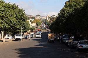
The city has more than 400 examples of Italian-style architecture,[22] wide streets, Piazzas and coffee bars. While the boulevards are lined with palms and local shiba'kha trees, there are numerable Pizzerias and coffee bars, serving cappucinos and lattes, as well as ice cream parlours and restaurants with Italian Eritrean cuisine.[22]
People in Asmara dress in a uniquely Eritrean style. It is one of the cleanest cities on the continent.
The city hosts the We Are the Future center, a child care center giving children a chance to live their childhoods and develop a sense of hope. The center is managed under the direction of the mayor’s office, and the international NGO Glocal Forum serves as the fundraiser and program planner and coordinator for the WAF child center in each city. Each WAF city is linked to several peer cities and public and private partners to create a unique international coalition.
Asmara was listed as a UNESCO World Heritage Site in July 2017, becoming the first modernist city anywhere to be listed in its entirety.[23]
The Historic Center of Asmara was placed on the World Monuments Fund's 2006 Watch List of 100 Most Endangered Sites. The listing was designed to bring more attention to the city to save the center from decay and redevelopment and to promote restoration.
Following CARP (a World Bank initiative on Cultural Heritage), the European Union Delegation in Asmara has engaged into a Heritage Project pertaining to building's restoration and archive management. Launched in 2010 the EU/Eritrea Cultural Project was expected to be completed in 2014 (Pierre Couté - Edward Denison, Project Design Report, EUD Asmara 2009).
Economy
As the capital city and largest settlement of Eritrea, most Eritrean businesses have their headquarters in Asmara. The city was once a factory town.
During the colonial period, Asmara was an administrative and commercial center of Italian East Africa. When the British entered the country in 1941, many businesses were closed down or relocated outside of the city. This trend continued under Ethiopian occupation.
Nasair[24][25] and the Eritrean Telecommunications Corporation are headquartered in the city.[26] In addition, country's national television station Eri-TV has many studios located in various areas in the capital.
The city of Asmara is a center for agricultural products and tanning hides. The primary industrial products of Asmara are: textiles, clothing, footwear, processed meat, beer, soft drinks, and ceramics.
Transport
After Eritrean independence, the roads of Asmara underwent extensive construction projects. Old roads were renovated and new highways were also built. There are only five primary roads out of Asmara, giving it its status as one of Africa’s most isolated capitals.[27]
Asmara International Airport serves the city with many international flights. Massawa International Airport is an alternate airport nearby.
Education
Asmara is home to the majority of colleges and universities. The city has always been a national centre of education, and is home to many elementary and high schools. Until the recent opening of universities at Mai Nefhi and Sawa, it was the seat of the only university in the country, the University of Asmara. During the period of Ethiopian Federation and annexation, the college was also linked with what was then the nation's largest tertiary institution, Addis Ababa University. Many campuses have been opening up across the country since independence, mainly for medicine and engineering.
University coursework in Eritrea is, for the most part, four years of academic study followed by one year of university national service in a relevant Eritrean Ministry. Once these five years are completed, students are then awarded their degree.
So far, this strategy has been rather successful in adding to the country’s human capital. Despite challenges in trying to equally balance human resources, most Eritreans want their career to help further their country’s success. In other words, most accept their university assignment as their social obligation to serve a bigger purpose.[28]
Universities and colleges
- University of Asmara
- Eritrea Institute of Technology
- Asmara Institute of Religious Studies
Primary and secondary schools
International schools
- Asmara International Community School – Anglophone international school
- Italian School of Asmara – Italian primary school with a Montessori department
- Liceo Sperimentale "G. Marconi" – Italian international senior high school
- Istituto Italiano Statale Comprensivo (IT) – Italian international elementary and junior high school
Districts
Asmara is divided into 13 districts or administrative areas. These districts are subdivided into North, North-West, North-East, South-East, South-West, East, West and Central areas. The thirteen districts (or Neous Zobas) are:
- North
- Acria District
- Abbashaul District
- Edaga Hamus District
- North-East
- Arbaete Asmara District
- North-West
- Mai Temenai District
- Paradiso District
- South-West
- Sembel District
- South-East
- Kahawuta District
- Godaif District
- Central
- Maakel Ketema District
- West
- Gheza Banda District
- Tsetserat District
- East
- Tiravolo District
- Gejeret District
References
- ↑ "CIA - The World Factbook". Retrieved 2 September 2012.
- ↑ "Eritrea capital Asmara makes World Heritage list". BBC News. Retrieved 2017-07-08.
- ↑ Mark Byrnes An African City's Unusual Preservation Legacy Feb 08, 2012 Atlantic Cities
- ↑ Palin, Michael (2007). Eritrea. Chalfont St Peter, United Kingdom: Bradt Travel Guides Ltd. p. 82. ISBN 978-1-84162-171-5.
- ↑ J.H. Arrowsmith-Brown, ed. (1991). Prutky's Travels to Ethiopia and Other Countries. Translated by J.H. Arrowsmith-Brown. London: Hakluyt Society. p. 78.
- ↑ Asmara italiana
- ↑ Ambraseys, Nicolas; Melville, C.P.; Adams, R.D. (1994). The Seismicity of Egypt, Arabia and the Red Sea: A Historical Review. Cambridge University Press. ISBN 0-521-39120-2.
- ↑ "Benvenuto sul sito del Maitacli" (in Italian). Archived from the original on 22 July 2011. Retrieved 8 July 2011.
- ↑ "Asmara useful for experimenting with radical designs for Europeans". Washington Times. 15 September 2007. Retrieved 8 December 2010.
- ↑ Italian architectural planification of Asmara (in Italian) p. 64-66
- ↑ Italian Eritrea industries
- ↑ Asmara, the capital of Art Deco
- ↑ Encyclopedia of Urban Cultures. Grolier Publishing Co. 2002.
- ↑ Hsu, Becky (ed.), Eritrea: Religious Distribution (PDF), p. 3, retrieved 22 December 2011
- ↑ Semere, Soloman (23 December 2005). "Groundwater study using remote sensing and geographic information systems (GIS) in the central highlands of Eritrea". Hydrogeology Journal. 14 (5): 729–741. doi:10.1007/s10040-005-0477-y.
- 1 2 Semere, Soloman (23 December 2005). "Groundwater study using remote sensing and geographic information systems (GIS) in the central highlands of Eritrea". Hydrogeology Journal. 14 (5): 729–741. doi:10.1007/s10040-005-0477-y.
- 1 2 3 4 Ghebrezgabher, Mihretab (September 7, 2015). "Extracting and analyzing forest and woodland cover change in Eritrea based on Landsat data using supervised classification". The Egyptian Journal of Remote Sensing and Space Science. 19 (1): 37–47. doi:10.1016/j.ejrs.2015.09.002.
- ↑ "Asmara Climate Normals 1961–1990". National Oceanic and Atmospheric Administration. Retrieved January 13, 2015.
- ↑ "Station Asmara" (in French). Meteo Climat. Retrieved 22 October 2016.
- ↑ Gianluca Rossi, Renzo Martinelli inviato de La Nazione, 2009.
- 1 2 "Reviving Asmara". BBC Radio 3. 19 June 2005. Retrieved 30 August 2006.
- 1 2 lorenzopinnavideo (2011-06-07), Asmara, la più bella città africana, retrieved 2017-09-18
- ↑ Wainwright, Oliver (8 July 2017). "The Italian architecture that shaped new world heritage site Asmara". The Guardian. Retrieved 9 July 2017.
- ↑ "World Airline Directory." Flight International. 23–29 March 2004. 68.
- ↑ "Fly Eritrean Hospitality". Nasair. Archived from the original on 31 May 2011. Retrieved 8 July 2011.
- ↑ Welcome to the Telecommunication Internet Service Provider - TSEiNET, archived from the original on 20 July 2011, retrieved 8 July 2011
- ↑ Stevis, Matina (2015-10-21). "What It's Like Inside Asmara, One of Africa's Most Isolated Capitals". Wall Street Journal. ISSN 0099-9660. Retrieved 2016-11-14.
- ↑ Müller, Tanja R. "'Now I Am Free'--Education And Human Resource Development In Eritrea: Contradictions In The Lives Of Eritrean Women In Higher Education." Compare: A Journal of Comparative Education 34.2 (2004): 215–229. Academic Search Complete.Web. 8 Nov. 2016.
Further reading
- Peter Volgger and Stefan Graf: "Architecture in Asmara. Colonial Origin and Postcolonial Experiences", DOM publishers, Berlin 2017, ISBN 978-3-86922-487-9
- Stefan Boness: "Asmara – Africa´s Jewel of Modernity". Jovis Verlag, Berlin 2016, ISBN 978-3-86859-435-5 (photo book; German, English)
- Stefan Boness: "Asmara – The Frozen City". Jovis Verlag, Berlin 2006. 96 pages. ISBN 3-936314-61-6 (photo book; German, English)
- Edward Denison, Guang Yu Ren, Naigzy Gebremedhin, and Guang Yu Ren, Asmara: Africa's Secret Modernist City (2003) ISBN 1-85894-209-8
- Gianluca Rossi, Renzo Martinelli inviato de “La Nazione”, 2009, ISBN 978-88-7255-356-5
External links
| Wikimedia Commons has media related to Asmara. |
| Wikivoyage has a travel guide for Asmara. |
- Asmara, Eritrea Documentary Film about the city by filmmaker Caterina Borelli
- History of Asmara
- Asmara inscription in UNESCO