Zanoah
| Zanoah | |
|---|---|
 | |
 Zanoah | |
| Coordinates: 31°43′55.91″N 34°59′57.12″E / 31.7321972°N 34.9992000°ECoordinates: 31°43′55.91″N 34°59′57.12″E / 31.7321972°N 34.9992000°E | |
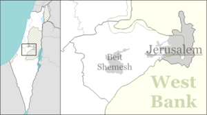
| District | Jerusalem |
| Council | Mateh Yehuda |
| Affiliation | Poalei Agudat Yisrael |
| Founded | 1950 |
| Founded by | Yemenite Jews |
| Population (2017)[1] | 486 |
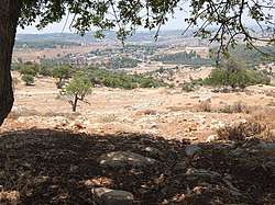
Zanoah (Hebrew: זָנוֹחַ) is a moshav in central Israel. Located adjacent to Beit Shemesh, it falls under the jurisdiction of Mateh Yehuda Regional Council. In 2017 it had a population of 486.
History
The village was established in 1950 by immigrants from Yemen, and was initially named Dayraban Gimel after the nearby depopulated Arab village of Dayr Aban.[2] In the following years the founders left and were replaced by immigrants from Morocco.
Geography and archaeology
Nahal Zanoah is a stream that runs north and drains into Nahal Sorek.[3]
The ruins (Khurbet Zanuʻ) on a hill south of the moshav are thought to be the ancient village of Zanoah mentioned in Egyptian letters, later part of the tribe of Judah (Joshua 15:34), and in the "Second Temple period ... reinhabited,"[4] as recorded in the Bible (Nehemiah 3:13). According to the Tosefta, the finest of the wheat used to grow in the valley adjacent to Zanoah, from whence it was taken for the offering of the Omer in the Temple. Although listed in Joshua 15:34 as being a city in the plain, it is actually partly in the hill country, partly in the plain.
C.R. Conder and H.H. Kitchener described the ruins of Khurbet Zanûa, visited by them in 1881.[5]
Education
The Beit Shemesh Yeshiva is located in Zanoah. Most of the students are from Ramat Beit Shemesh Alef. Aside from Talmud study, the curriculum includes English language and mathematics, and unlike many such institutions in Israel today, students study for the Bagrut matriculation exams.[6] From 2004 to 2015, when it closed, Zanoah was also the home of Yeshivat Yesodei HaTorah, which offered a gap year program for international English-speaking students.
References
- ↑ "List of localities, in Alphabetical order" (PDF). Israel Central Bureau of Statistics. Retrieved August 26, 2018.
- ↑ Yalqut Teiman, Yosef Tobi and Shalom Seri (editors), Tel-Aviv 2000, p. 82, s.v. זנוח (Hebrew) ISBN 965-7121-03-5
- ↑ Follow the red rock road The Jerusalem Post
- ↑ Carta's Official Guide to Israel and Complete Gazetteer to all Sites in the Holy Land. (3rd edition 1993) Jerusalem, Carta, p.481, ISBN 965-220-186-3
- ↑ C.R. Conder & H.H. Kitchener, Survey of Western Palestine - Memoirs of the Topography, Orography, Hydrography, and Archaeology [Judæa] (vol. 3), London 1883, pp. 128–129
- ↑ Black and white in color Haaretz
External links
- Zanoah in Antiquity Archaeological Survey of Israel
| Wikimedia Commons has media related to Zanoah. |