Deir Rafat
| Deir Rafat דיר ראפאת دير رفات | |
|---|---|
 | |
 Deir Rafat | |
| Coordinates: 31°46′34″N 34°56′47″E / 31.77611°N 34.94639°ECoordinates: 31°46′34″N 34°56′47″E / 31.77611°N 34.94639°E | |
| Grid position | 144/131 PAL |
| District | Jerusalem |
| Council | Mateh Yehuda |
| Founded | 1927 |
| Founded by | Luigi Barlassina |
| Population (2017)[1] | 88 |
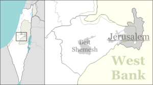
Deir Rafat (Arabic: دير رفات, Hebrew: דיר ראפאת), also known as the Shrine of Our Lady Queen of Palestine and of the Holy Land, is a Catholic monastery in central Israel. Located to the north-west of Beit Shemesh, between Givat Shemesh and kibbutz Tzora to the south and Kfar Uria to the north, it falls under the jurisdiction of Mateh Yehuda Regional Council. In 2017 it had a population of 88.[1]
History
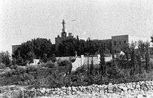
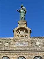
The monastery was established in 1927 by the Latin patriarch Luigi Barlassina and contained a boarding school, an orphanage and convent. Currently the convent is running a guest house and a retreat center for believers and Holy Land pilgrims. The façade of the convent church bears the Latin inscription "Reginae Palaestinae", lit. "to the Queen of Palestine", and carries a 6-metre statue of the Virgin Mary. The church ceiling is decorated with a painting showing angels carrying banners with the first words of the Hail Mary prayer in 280 languages.[2][3] Since 2009, the convent is in the care of the female branch of the Catholic order known as "the Monastic Family of Bethlehem, of the Assumption of the Virgin and of Saint Bruno", called the monastic Sisters of Bethlehem.[2]

References
- 1 2 "List of localities, in Alphabetical order" (PDF). Israel Central Bureau of Statistics. Retrieved August 26, 2018.
- 1 2 Monastère Notre-Dame de Palestine: Deir Rafat Monastic Family of Bethlehem
- ↑ The Shrine of Our Lady "Queen of Palestine" and the Holy Land at Rafat LPJ
Bibliography
| Wikimedia Commons has media related to Deir Rafat. |
- Betzer, Pablo (2014-12-14). "Deir Rafat (East)" (126). Hadashot Arkheologiyot – Excavations and Surveys in Israel.
- Conder, C.R.; Kitchener, H.H. (1883). The Survey of Western Palestine: Memoirs of the Topography, Orography, Hydrography, and Archaeology. 3. London: Committee of the Palestine Exploration Fund. (pp. 154-5)
- Guérin, V. (1868). Description Géographique Historique et Archéologique de la Palestine (in French). 1: Judee, pt. 1. Paris: L'Imprimerie Nationale.
- Palmer, E.H. (1881). The Survey of Western Palestine: Arabic and English Name Lists Collected During the Survey by Lieutenants Conder and Kitchener, R. E. Transliterated and Explained by E.H. Palmer. Committee of the Palestine Exploration Fund.
- Robinson, E.; Smith, E. (1841). Biblical Researches in Palestine, Mount Sinai and Arabia Petraea: A Journal of Travels in the year 1838. 3. Boston: Crocker & Brewster. (p. 20)
External links
- Survey of Western Palestine, Map 17: IAA, Wikimedia commons