Dalaguete
| Dalaguete | |
|---|---|
| Municipality | |
| Municipality of Dalaguete | |
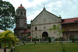 St William of Aquitaine church | |
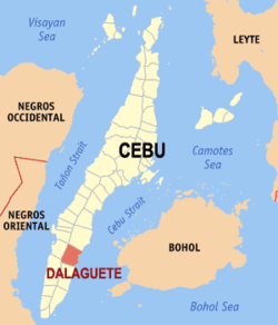 Map of Cebu with Dalaguete highlighted | |
.svg.png) Dalaguete Location within the Philippines | |
| Coordinates: 9°46′N 123°32′E / 9.77°N 123.53°ECoordinates: 9°46′N 123°32′E / 9.77°N 123.53°E | |
| Country |
|
| Region | Central Visayas (Region VII) |
| Province | Cebu |
| District | 2nd district of Cebu |
| Founded | 1711 |
| Barangays | 33 (see Barangays) |
| Government [1] | |
| • Type | Sangguniang Bayan |
| • Mayor | Ronald Cesante |
| • Vice Mayor | Jeffrey Belciña |
| • Congressman | Wilfredo Caminero |
| • Electorate | 35,658 voters (2016) |
| Area [2] | |
| • Total | 154.96 km2 (59.83 sq mi) |
| Elevation | 9 m (30 ft) |
| Population (2015 census)[3] | |
| • Total | 67,497 |
| • Density | 440/km2 (1,100/sq mi) |
| Time zone | UTC+8 (PST) |
| ZIP code | 6022 |
| PSGC | 072222000 |
| IDD : area code | +63 (0)32 |
| Climate type | Tropical climate |
| Income class | 1st municipal income class |
| Revenue (₱) | 155,117,637.74 (2016) |
| Native languages |
Cebuano Tagalog |
| Website |
dalaguete |
Dalaguete, officially the Municipality of Dalaguete, (Cebuano: Lungsod sa Dalaguete; Tagalog: Bayan ng Dalaguete), is a 1st class municipality in the province of Cebu, Philippines. According to the 2015 census, it has a population of 67,497 people.[3]
Located 84 kilometres (52 mi) south of Cebu City.
Dalaguete is bordered to the north by the town of Argao, to the west are the towns of Badian and Alegria, to the east is the Cebu Strait, and to the south is the town of Alcoy.
Dalaguete offers one of the trails to Cebu's highest summit, the Osmeña Peak.
History
The natives look upon the tree not for its gigantic size, nor for its fruit which is of no use, but rather for the religious observance of the natives.
They highly consider this tree for their belief that it harbors spirits or diwatas who could impose sickness if maltreated or hand in fortunes and gifts if placated. When fully grown, the intertwining roots are exposed from the earth and form huge caverns that could house several people.[4]
The dalakit (Ficus benjamina) tree is the foundation of the origin and name of Dalaguete. In ancient times, before the coming of the Spaniards, these trees had been used by people as major landmarks. People gathered under the encompassing shades and conduct social and economic activities such us festivities, contest, trading meetings and other community gatherings. They establish market places under the shades of the dalaket where they sell their products and conduct trade with local roving traders bringing in Chinese and Asiatic goods from the port of Cebu.[4]
The place where the church or the poblacion were laid would have been the site of a communal gathering area for the natives. It was also the abode of a huge dalaket tree which provide shade and shelter while people conduct their activities. "Adto ta mag-abot sa dalakit". "Adto ta magtigom-tigom sa dalakit" [Let us meet at the dalakit]. These and other popular phrases have the common practice of our ancestors when coming up with an agreement to meet or conduct an activity specifically at the site where the dalakit is situated. For several generations in pre-Hispanic Dalaguete, the area has always been unofficially called as dalakit. Its accessibility and its reputation as a communal area for community gathering have prompted the Spanish authorities to construct the church and eventually establish the area as part of an encomienda. From this common ground, and from this tree, begun the conception of a larger town which later come to be known as Dalaguete.[4]
Geography
Land characteristics
- Land Area: 15,496 hectares (38,290 acres)
- Topography: 85% hilly and mountainous with more than 30% slope
- Land Use:
- 45% protected area and watersheds
- 30% agriculture (prime area for vegetable production in the province)
- 6% built-up area (proj. 2010: 6 - 15%)
Climate
Tropical climate prevails year round in Dalaguete. The temperature is high and varies little with a difference of about 3 °C (5.4 °F) between the coldest month which occurs around January and hottest month around May. The mountain barangays are cold and Mantalongon is considered the "Little Baguio of Cebu". Average daytime temperatures except in mountainous region range from 22.2 to 32.1 °C (72.0 to 89.8 °F). Humidity is 77%.
Barangays
Dalaguete comprises 33 barangays:
| PSGC | Barangay | Population | ±% p.a. | Area | PD 2015 | |||||
|---|---|---|---|---|---|---|---|---|---|---|
| 2015[3] | 2010[5] | ha | acre | /km2 | /sq mi | |||||
| 072222001 | Ablayan | 1.8% | 1,207 | 1,146 | 0.99% | 450 | 1,112 | 270 | 690 | |
| 072222002 | Babayongan | 0.7% | 468 | 458 | 0.41% | 386 | 954 | 120 | 310 | |
| 072222003 | Balud | 4.8% | 3,214 | 3,044 | 1.04% | 128 | 316 | 2,500 | 6,500 | |
| 072222004 | Banhigan | 1.8% | 1,239 | 1,240 | −0.02% | 121 | 299 | 1,000 | 2,700 | |
| 072222005 | Bulak | 1.3% | 873 | 893 | −0.43% | 460 | 1,137 | 190 | 490 | |
| 072222007 | Caleriohan | 3.3% | 2,202 | 1,861 | 3.26% | 353 | 872 | 620 | 1,600 | |
| 072222006 | Caliongan | 3.4% | 2,319 | 2,298 | 0.17% | 889 | 2,197 | 260 | 680 | |
| 072222008 | Casay | 6.3% | 4,283 | 4,103 | 0.82% | 353 | 872 | 1,200 | 3,100 | |
| 072222009 | Catolohan | 2.6% | 1,759 | 1,587 | 1.98% | 945 | 2,335 | 190 | 480 | |
| 072222010 | Cawayan | 4.0% | 2,681 | 2,599 | 0.59% | 297 | 734 | 900 | 2,300 | |
| 072222011 | Consolacion | 2.9% | 1,966 | 1,561 | 4.49% | 194 | 479 | 1,000 | 2,600 | |
| 072222012 | Coro | 1.8% | 1,228 | 1,019 | 3.62% | 264 | 652 | 470 | 1,200 | |
| 072222013 | Dugyan | 1.5% | 994 | 1,094 | −1.81% | 308 | 761 | 320 | 840 | |
| 072222014 | Dumalan | 2.6% | 1,756 | 1,664 | 1.03% | 891 | 2,202 | 200 | 510 | |
| 072222015 | Jolomaynon | 2.0% | 1,338 | 1,458 | −1.62% | 469 | 1,159 | 290 | 740 | |
| 072222016 | Lanao | 1.7% | 1,124 | 1,094 | 0.52% | 575 | 1,421 | 200 | 510 | |
| 072222017 | Langkas | 2.0% | 1,344 | 1,191 | 2.33% | 326 | 806 | 410 | 1,100 | |
| 072222018 | Lumbang | 1.1% | 773 | 791 | −0.44% | 110 | 272 | 700 | 1,800 | |
| 072222019 | Malones | 1.9% | 1,291 | 1,145 | 2.31% | 237 | 586 | 540 | 1,400 | |
| 072222020 | Maloray | 1.4% | 941 | 918 | 0.47% | 433 | 1,070 | 220 | 560 | |
| 072222021 | Mananggal | 1.6% | 1,047 | 1,025 | 0.41% | 166 | 410 | 630 | 1,600 | |
| 072222023 | Manlapay | 3.2% | 2,152 | 2,095 | 0.51% | 526 | 1,300 | 410 | 1,100 | |
| 072222024 | Mantalongon | 9.7% | 6,517 | 5,238 | 4.25% | 917 | 2,266 | 710 | 1,800 | |
| 072222025 | Nalhub | 2.7% | 1,834 | 1,797 | 0.39% | 703 | 1,737 | 260 | 680 | |
| 072222026 | Obo | 2.1% | 1,392 | 1,651 | −3.20% | 483 | 1,194 | 290 | 750 | |
| 072222027 | Obong | 4.6% | 3,078 | 3,277 | −1.19% | 940 | 2,323 | 330 | 850 | |
| 072222028 | Panas | 1.2% | 832 | 727 | 2.60% | 357 | 882 | 230 | 600 | |
| 072222029 | Poblacion | 9.4% | 6,355 | 5,893 | 1.45% | 144 | 356 | 4,400 | 11,000 | |
| 072222030 | Sacsac | 2.6% | 1,726 | 1,509 | 2.59% | 597 | 1,475 | 290 | 750 | |
| 072222033 | Salug | 1.6% | 1,106 | 1,003 | 1.88% | 372 | 919 | 300 | 770 | |
| 072222034 | Tabon | 4.6% | 3,094 | 3,056 | 0.24% | 510 | 1,260 | 610 | 1,600 | |
| 072222031 | Tapun | 6.0% | 4,068 | 3,577 | 2.48% | 202 | 499 | 2,000 | 5,200 | |
| 072222032 | Tuba | 1.9% | 1,296 | 1,227 | 1.05% | 940 | 2,323 | 140 | 360 | |
| Total | 67,497 | 63,239 | 1.25% | 15,496 | 38,291 | 440 | 1,100 | |||
Demographics
| Population census of Dalaguete | ||
|---|---|---|
| Year | Pop. | ±% p.a. |
| 1903 | 21,354 | — |
| 1918 | 26,904 | +1.55% |
| 1939 | 27,284 | +0.07% |
| 1948 | 29,333 | +0.81% |
| 1960 | 28,487 | −0.24% |
| 1970 | 31,834 | +1.12% |
| 1975 | 33,964 | +1.31% |
| 1980 | 37,076 | +1.77% |
| 1990 | 45,545 | +2.08% |
| 1995 | 48,778 | +1.29% |
| 2000 | 57,331 | +3.52% |
| 2007 | 61,405 | +0.95% |
| 2010 | 63,239 | +1.08% |
| 2015 | 67,497 | +1.25% |
| Source: Philippine Statistics Authority[3] [5] [6] [7] | ||
Economy
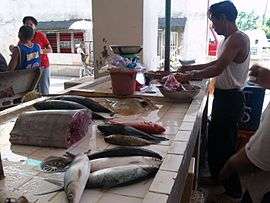
- Agriculture: farming, fishing
- Products: vegetables, fish
- Cottage industry: blanket & mat weaving, basket making
- Mineral Resources: ice stones, lime red stone, lime pink stones, wood stones, phosphate, coal
Religious institutions
| Roman Catholic Parishes | Protestant Churches | Independent (Non-Sectarian) |
|---|---|---|
|
|
Jehovah's Witnesses (Poblacion) [8] |
|
|
|
|
|
|
|
|
BIBLE BAPTIST CHURCH, TAPUN SITIO PANAGUIKAN DALAGUETE
Utanon Festival
Dalaguete celebrates its annual town fiesta in honor of its patron saint, San Guillermo, every 9 and 10 February. One of the highlights of the celebration is the street dancing and showdown competition called "Utanon Festival".
Utanon Festival is also a form of thanksgiving for all the blessings and graces the Dalaguetenons have received from San Guillermo and for giving them a place so rich in agriculture and music. Utanon Festival is a celebration of good harvest through dance and music. The town is known as the "Vegetable Basket of Cebu" and Mantalongon as the "Summer Capital of Cebu".
References
- ↑ "Municipality". Quezon City, Philippines: Department of the Interior and Local Government. Retrieved 31 May 2013.
- ↑ "Province: Cebu". PSGC Interactive. Quezon City, Philippines: Philippine Statistics Authority. Retrieved 12 November 2016.
- 1 2 3 4 Census of Population (2015). "Region VII (Central Visayas)". Total Population by Province, City, Municipality and Barangay. PSA. Retrieved 20 June 2016.
- 1 2 3 "Origin of the name "Dalaguete"". Municipal Government of Dalaguete. Archived from the original on 2015-10-31. Retrieved 31 October 2015.
- 1 2 Census of Population and Housing (2010). "Region VII (Central Visayas)". Total Population by Province, City, Municipality and Barangay. NSO. Retrieved 29 June 2016.
- ↑ Censuses of Population (1903–2007). "Region VII (Central Visayas)". Table 1. Population Enumerated in Various Censuses by Province/Highly Urbanized City: 1903 to 2007. NSO.
- ↑ "Province of Cebu". Municipality Population Data. Local Water Utilities Administration Research Division. Retrieved 17 December 2016.
- ↑ "Are Jehovah's Witnesses Protestants? | FAQ". JW.ORG. Retrieved 2017-09-13.
- ↑ "Statistics". Municipal Government of Dalaguete. Archived from the original on 2015-10-31. Retrieved 31 October 2015.
Sources
- Alcina, Fr Francisco Ignacio (1668). Historia natural del sitio, fertilidad y calidad de las Islas e Indios de Bisayas (in Spanish).
| Wikimedia Commons has media related to Dalaguete. |
External links
Places adjacent to Dalaguete | ||||||||||
|---|---|---|---|---|---|---|---|---|---|---|
| ||||||||||
Cebu City (capital) | |
| Municipalities |
|
| Component cities | |
| Highly urbanized cities | (Administratively independent from the province but grouped under Cebu by the Philippine Statistics Authority. However, qualified voters in Mandaue are allowed to vote in elections for Cebu provincial officials as part of the 6th Sangguniang Panlalawigan district.) |
![]()