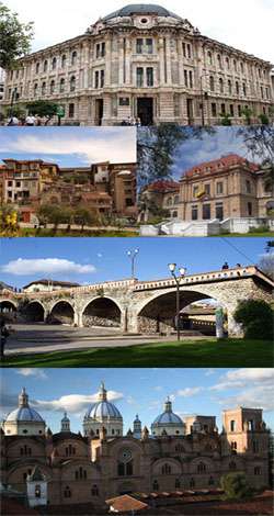
Cuenca, Ecuador
| Cuenca | |||
|---|---|---|---|
| City | |||
| Cuenca, Ecuador | |||
 Panoramic view of Cuenca, Ecuador, from Turi area | |||
| |||
| Nickname(s): Atenas del Ecuador (Athens of Ecuador) | |||
 Cuenca Location in Ecuador | |||
| Coordinates: 2°53′50.69″S 79°00′16.13″W / 2.8974139°S 79.0044806°WCoordinates: 2°53′50.69″S 79°00′16.13″W / 2.8974139°S 79.0044806°W | |||
| Country | Ecuador | ||
| Province | Azuay | ||
| Canton | Cuenca Canton | ||
| Founded | April 12, 1557 | ||
| Founded by | Gil Ramírez Dávalos | ||
| Named for | Cuenca, Spain | ||
| Parishes |
Urban Parishes
| ||
| Government | |||
| • Mayor | Marcelo Cabrera | ||
| Area | |||
| • City | 70.59 km2 (27.25 sq mi) | ||
| Elevation | 2,560 m (8,400 ft) | ||
| Highest elevation | 2,550 m (8,370 ft) | ||
| Lowest elevation | 2,350 m (7,710 ft) | ||
| Population (2015)INEC estimates | |||
| • City | 400,000 | ||
| • Density | 5,700/km2 (15,000/sq mi) | ||
| • Metro | 700,000 | ||
| The population total is of the urban parishes of the Municipality of Cuenca (the canton), which make up the city of Cuenca; the metro population is the population of the canton cuenca, areas urbanas of azogues , biblian and deleg in the cañar province. Gualaceo and Paute in the azuay province. | |||
| Demonym(s) | Cuencan | ||
| Time zone | UTC-5 (ECT) | ||
| Postal code | 010150 | ||
| Area code(s) | (+593) 07 | ||
| Climate | Cfb | ||
| Website | Official website (in Spanish) | ||

.png)
.jpg)
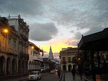
The city of Cuenca — in full, Santa Ana de los Cuatro Ríos de Cuenca — is the capital of the Azuay Province. It is widely regarded as the most European city in the country of Ecuador due to its 16th and 17th century era Spanish colonial architecture resembling cities and architecture throughout Spain. The city of Cuenca is located in the highlands of Ecuador at about 2,560 metres (8,400 feet) above sea level, with an urban population of approximately 400,000 rising to 700,000 inhabitants in the larger metropolitan area. The centre of the city is listed as a UNESCO World Heritage Site due to its many historical buildings.
History
First inhabitants
According to studies and archeological discoveries, the origins of the first inhabitants go back to the year 8060 BC in the Cave of Chopsi. They were hunters, hunting everything the Páramo offered them, and nomads, following the animals and seasons. Their culture is represented by tools such as arrows and spears, which have been found throughout the Andean valley. The culture was most present about 5585 BC.
Later the early indigenous people used the stable climate, fertile soil and abundant water to develop agriculture. They grew potatoes, melloco, chocho, squash and quinoa. They also domesticated animals such as cuys (guinea pigs) and camelids: llamas and alpacas.
Their technology was also advanced. For example, they started creating ceramics. In fact, ceramics constitute the greatest number of artifacts which archeologists use to study their culture. The period from 5000 BCE to 2000 BCE is not represented well in the archeological record. Beginning around 2000 BCE, the people developed a more highly organized society, demonstrating delegated responsibilities, such as the managing of water and control of plagues. People were specialized as administrative and religious authorities (known as shamans). This occurred during the periods of Chaullabamba, Huayco, Pirincay, Monjas, Putushio, Huancarcucho and Jubones. From then until 500 AD began the periods of Tacalshapa III and the Cañari people, who were absorbed into the Incas in the 15th century.
Pre-Columbian society
Cuenca was originally a Cañari settlement called Guapondeleg. Archeologists believe Cuenca was founded around 500 AD. Guapondeleg translates into "land as big as heaven." Less than half a century before the conquistadors landed, the Incas, after a bitter struggle, conquered the Cañari and occupied Guapondeleg and the surrounding area. Though the Incas replaced the Cañari architecture with their own, they did not suppress the Cañari or their impressive achievements in astronomy and agriculture. As was customary for the Incas, they absorbed useful achievements into their culture. They renamed the city Tomebamba. The city became known as the second Cusco, a regional capital.
After the defeat of the Cañari, probably in the 1470s, the Inca emperor, Tupac Yupanqui, ordered the construction of a grand city to be called Pumapungo, "the door of the Puma". Its magnificence was said to have rivaled that of the Inca capital of Cuzco. Indians told stories to the Spanish chroniclers of golden temples and other such wonders, but by the time the Spaniards found the legendary city, all that remained were ruins. They wondered what happened to the fabled splendor and riches of the second Inca capital. After having been abandoned by the Cañari and then the Incas, Tomebamba was sparsely populated until the 1550s.
Tomebamba is considered a candidate for the mythical city of gold which the Spanish called El Dorado. The Spanish thought El Dorado was burned by the inhabitants after they heard of the Spanish conquests. Tomebamba's destruction by its inhabitants prior to the arrival of the Spanish suggests it may have been what the Spanish called El Dorado.
Spanish settlement
The Spanish settlement of Cuenca was founded on April 12, 1557 by the explorer Gil Ramírez Dávalos. Andrés Hurtado de Mendoza, then Viceroy of Peru had commissioned the founding and ordered the city named after his home town of Cuenca, Spain. It was founded decades after other major Spanish settlements in the region, such as Quito (1534), Guayaquil (1538), and Loja (1548). Cuenca's population and importance grew steadily during the colonial era. It reached the peak of its importance in the first years of Ecuador's independence; Cuenca achieved its independence on November 3, 1820. It became the capital of one of the three provinces that made up the nascent republic. The other two capitals were Guayaquil and Quito.
Population
As per the last INEC estimate for 2015, the population of the Cuenca canton was 580,000 inhabitants, of which 400,000 constitute the urban population (i.e., the population of the city proper). The economic development is based on industry and agricultural development.
Cuenca Metropolitan Area includes the cities of Azogues, Biblian and Deleg in the cañar province and the cities of Paute and Gualaceo in the Azuay province with a population of 730,000 inhabitants, however, Cuenca's influence in the cultural, economic and educational areas extends to all the remaining cities 50 miles (80 kilometres) around.
Economy
Cuenca is a city known for its textile making, along with furniture and other crafts like hats and shoes. They also export many flowers to places such as the United States and countries in Europe. The hats that they are well known for making are straw hats. The tourism industry is big as well in addition with the main university there, “La Universidad de Cuenca”. Cuenca has many cathedrals there that are a part of the sightseeing as well as other national parks. For the future, Ecuador has been working on electrolytic hydrogen for use of better resources that are environmental friendly. With Cuenca located in the sierras of mountains and much forest area nearby, mining and logging are industries there. Some of the common mined resources are kaolin, plaster, limestone, sand, specialized rocks, and carbon. Also, Cuenca is known for making tires for cars. As far as farming, it has shrunken in the economy, but is still important part of the city. Beekeeping is actually a big part of it as far as the usual of livestock and growing crops. Some of the typical crops grown are wheat, barley, rye, oats and corn.[1]
Geography and location economy
Cuenca, capital of the province of Azuay, is located in the sierra of the Andes in the Austro or southern region of Ecuador. It is approximately nine hours south of Quito and four hours east of Guayaquil. The city ranges from 2,350 to 2,550 metres (7,710 to 8,370 feet) above sea level.
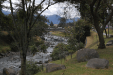
The dominant features of the city's geography are also the source of its name in Spanish: the four rivers of Cuenca (meaning a basin made by a confluence of rivers). These rivers are the Tomebamba (named after the Inca culture), Yanuncay, Tarqui and Machangara, in order of importance. The first three of these rivers originate in the Páramo of Parque Nacional Cajas to the west of the city. These four rivers are part of the Amazon river watershed. Cuenca is surrounded by mountains on all sides, with passes to the west, south and east.
Parishes
Cuenca Canton contains the following parishes:
Climate
Cuenca features a subtropical highland climate (Cfb) under the Köppen climate classification. Like the rest of the Ecuadorian Andes, Cuenca enjoys a mild climate year-round. Days are generally warm and nights are cool enough that sweaters or jackets are usually desired. The average daily temperature is 14.7 °C (58.5 °F). There are two seasons: rainy and dry. The dry season, with some variation, falls between June and December. The rainy season, which is characterized by bright sunny mornings and afternoon showers, falls between January and May. The heaviest rains come in the invierno (wet season) of March, April and May.
| Climate data for Cuenca, Ecuador | |||||||||||||
|---|---|---|---|---|---|---|---|---|---|---|---|---|---|
| Month | Jan | Feb | Mar | Apr | May | Jun | Jul | Aug | Sep | Oct | Nov | Dec | Year |
| Record high °C (°F) | 33.0 (91.4) |
29.9 (85.8) |
28.8 (83.8) |
33.0 (91.4) |
32.0 (89.6) |
31.6 (88.9) |
29.5 (85.1) |
34.0 (93.2) |
31.2 (88.2) |
33.0 (91.4) |
33.0 (91.4) |
33.0 (91.4) |
34.0 (93.2) |
| Average high °C (°F) | 22.4 (72.3) |
22.4 (72.3) |
21.9 (71.4) |
21.7 (71.1) |
21.4 (70.5) |
20.4 (68.7) |
19.9 (67.8) |
20.4 (68.7) |
21.3 (70.3) |
22.3 (72.1) |
23.1 (73.6) |
23.1 (73.6) |
21.7 (71) |
| Daily mean °C (°F) | 15.3 (59.5) |
15.8 (60.4) |
15.6 (60.1) |
15.3 (59.5) |
14.4 (57.9) |
13.6 (56.5) |
13.3 (55.9) |
13.3 (55.9) |
14.7 (58.5) |
15.3 (59.5) |
14.7 (58.5) |
15.6 (60.1) |
14.7 (58.5) |
| Average low °C (°F) | 10.9 (51.6) |
11.1 (52) |
11.2 (52.2) |
10.9 (51.6) |
10.6 (51.1) |
9.8 (49.6) |
9.4 (48.9) |
9.1 (48.4) |
9.5 (49.1) |
10.1 (50.2) |
10.2 (50.4) |
10.6 (51.1) |
10.3 (50.5) |
| Record low °C (°F) | 0.0 (32) |
0.0 (32) |
1.0 (33.8) |
1.0 (33.8) |
0.0 (32) |
−0.6 (30.9) |
−3.0 (26.6) |
−1.1 (30) |
−1.0 (30.2) |
−2.0 (28.4) |
−0.6 (30.9) |
0.0 (32) |
−3.0 (26.6) |
| Average rainfall mm (inches) | 67 (2.64) |
85 (3.35) |
107 (4.21) |
109 (4.29) |
77 (3.03) |
68 (2.68) |
53 (2.09) |
47 (1.85) |
56 (2.2) |
73 (2.87) |
69 (2.72) |
67 (2.64) |
878 (34.57) |
| Average rainy days (≥ 0.1 mm) | 20 | 21 | 22 | 19 | 15 | 11 | 10 | 10 | 12 | 16 | 13 | 10 | 179 |
| Mean monthly sunshine hours | 155 | 113 | 124 | 120 | 155 | 150 | 186 | 186 | 150 | 155 | 150 | 155 | 1,799 |
| Source #1: Temperatures: Climate Ecuador,[3] Voodoo Skies[4] | |||||||||||||
| Source #2: Other: Cuenca Climate Guide [5] | |||||||||||||
Education
Universities
The first university in the city was established in 1867 and is the Universidad de Cuenca. It is considered the third oldest university of the country, right after the Universidad Central del Ecuador (1836) and the Universidad Nacional de Loja (1859). Ever since, the city has been growing and more universities were created with new careers. This led to the declaration of Cuenca as the City of Universities by the National Assembly of Ecuador on January 4, 2011.[6]
The city has the following Universities:
- Universidad de Cuenca (UCUENCA)
- Universidad Politécnica Salesiana (UPS)
- Universidad del Azuay (UDA)
- Universidad Católica de Cuenca (UCACUE)
The first one is classified as an A category university the next two are B category and the last one is D category. This was stated by the Council for Evaluation, Validation and Assurance of the Quality in Superior Education of Ecuador (CEAACES)[7]
Primary and secondary schools
International schools:
- École franco-équatorienne Joseph-de-Jussieu (French school)
- Colegio Alemán Stiehle (German school)
Main sights
| UNESCO World Heritage site | |
|---|---|
 The Catedral Nueva | |
| Criteria | Cultural: ii, iv, v |
| Reference | 863 |
| Inscription | 1999 (23rd Session) |
| Area | 224.14 ha |
| Buffer zone | 1,836.94 ha |
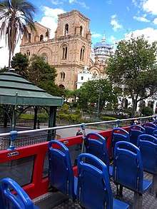
Most tourists visit the historic area, which is a UNESCO World Heritage Site, between the river Tomebamba and the street Gran Colombia to the north, General Torres to the west, and Hermano Miguel to the east. This area's compactness, grid-like layout, and numerous readily identifiable monuments make it easy to navigate. Outside this area the city can be confusing, as there are dozens of narrow colonial streets with similar buildings.
Major fiestas of Cuenca come at the time of the "Mass of Children" that is carried out the day of the Arrival of Kings (January 6 - Epiphany Day), or in the commemoration of the independence of the city (November 3), during which processions, cultural acts and dances are organized. The nearby Cañar plantation (in the county of the same name) features the biggest Inca ruins in Ecuador.
Landmarks
- Old Cathedral (Iglesia de El Sagrario). Built in 1557, the edifice eventually became too small for the town's attendants. In 1880, a new cathedral was built as the replacement. The old cathedral, no longer consecrated, has been restored and used as a museum.
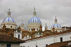
- New Cathedral (official name: Catedral Metropolitana de la Inmaculada Concepción). Its towers are truncated due to a calculation error of the architect. Had it been constructed as planned, the foundation would not bear the weight of the full towers. In spite of the architect's immeasurable mistake, the New Cathedral of Cuenca, completed in 1975, is a monumental work of faith. A combination of Romanesque Revival and Neo-Gothic in style, the church's blue and white domes have become a symbol for the city. Its façade is made of alabaster and local marble, while the floor of the nave is covered with pink marble, brought from Carrara (Italy). At its inauguration, the newly constructed Cathedral could accommodated 9,000 out of Cuenca's 10,000 inhabitants at that time.
- Park Abdon Calderon. It is located in the center of Cuenca between the old and new cathedrals. On the park benches, people meet to converse and absorb its tranquility. The municipal offices are located nearby.
- Monastery of El Carmen de Asuncion. In the atrium a colorful flower market supplements the beauty of the church which was founded in 1682. A sculpted stone façade and a golden pulpit make the church very attractive.
- Monastery and Museum of La Concepcion, with 17th-century tombs and a complete collection of religious art.
- House of the Ecuadorian Culture
- Municipal Museum Remigio Crespo Toral
- Museum of the Central Bank
- Museum of the Aboriginal Cultures
- Church of Santo Domingo
- San Blas
- Turi the Mirador
- Ruinas de todos los santos. In this old place, four niches of Inca origin exist. Their form is trapezoidal and they are built of stone. There are also remains of a colonial mill.

Surroundings
- Molleturo, a vast rural area (about 1,000 square kilometres or 386 square miles) situated in Ecuador’s southern Andes, and composed of several little villages (hamlets). The centre of the area is located at 1.5 hours of distance in car from the nearest bigger city (Cuenca). In fact, this distance is very little compared to ten years ago when there was no road for cars and it took people 3 days of mule riding to get to Cuenca. In spite of the advantages, the road had also very negative impacts on the ecological system, which is still very important for people's daily survival.
- Jima, located near Cuenca, is a hiking hotspot for southern Ecuador. Jima is located at the base of two beautiful green mountains at 8,800 feet (2,700 metres). Hikes for all skill levels are available including a three-day hike from the peaks of the Andes mountains down into the lush tropical rainforest of the Amazon basin.
- Gualaceo
- Chordeleg. Less than 50 kilometres (31 miles) from Cuenca, it is a town of Cañari origin, known for its weavers, embroiderers and potters. In the same area there is a stone corridor in snake form, built in pre-Inca time, known for gold and silver smiths and local jewelry.
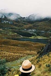
- El Cajas, a national park where the rivers, streams, and lagoons seem to unite to create a temple of nature, in which the altitude varies from 3,500 to 4,200 metres (11,500 to 13,800 feet) above sea level. It is a place for bird watchers and trout fishermen.

- Azogues, the capital of Cañar Province, 29 kilometres (18 miles) from Cuenca. In this city of colonial atmosphere, one of the highlights is San Francisco's convent, built on the summit of a huaca (sacred mountain) of the prehispanic residents.
- Cañar plantation, with a colorful market and the nearby ruins of Ingapirca (wall of Inca stone). Cañar plantation is located 65 kilometres (40 miles) from Cuenca and it is usually the starting point for the trips to the famous ruins that, according to the experts, were used to control the native Cañaris. Stores, bathrooms, a tambo for the Inca, a temple dedicated to the sun, they are part of Ingapirca that was built in the 15th century by orders of Huayna Capac.
Culture
Festivities
One of the festivities celebrated in Cuenca and in other parts of Ecuador is "El Carnaval" This is celebrated three days prior to Ash Wednesday. Families get together to celebrate what started as a "pagan ritual". Now it is celebrated by wetting friends and random people with water balloons and spraying "Carioca" a non staining foam.
Transport
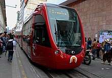
Bus station
Cuenca's inter-provincial bus station, called the Terminal Terrestre as it is in most cities, is well organized and clean. It is located on Avenida España in the northeastern corner of the city, a twenty-minute walk or a brief taxi ride from the historic center. Also, many City buses provide frequent service as indicated by the "Terminal Terrestre" placard on the windshield. A guide to using the City buses, maps of the routes and an online trip planner can be found at CuencaTransit.com
Buses arrive and depart throughout the day. Service is available to major cities, such as Guayaquil and Quito and also to nearby cities such as Loja, Riobamba, or Machala. The distance to Guayaquil is 243 km. and the bus takes nearly 4 hours on the highway Durán-Pto.Inca-Molleturo (I582W), a scenic ride through the Cajas National Park. Quito is 497 km from Cuenca and the trip takes around 10 hours on the Road Pan-American Highway (I35N). Many prefer to travel by bus at night. Those who choose to travel overnight should exercise caution due to reported bus hijacks which have resulted in armed robbery. [citation needed]
Airport
The airport, named Aeropuerto Mariscal Lamar (Mariscal Lamar International Airport), is due east of the Terminal Terrestre (bus station) on Avenida España. It's a 5-minute walk from the bus station. Four airlines currently serve Cuenca; AeroGal, LAN Ecuador, and TAME fly to Quito daily while Línea Aérea Cuencana (no longer operating as of November 2013) and TAME fly to Guayaquil. This is Ecuador's third busiest airport. Over 1,400,000 passengers a year pass through its gates.
Cuenca public transportation statistics
According to the Moovit Public Transport Index, Cuenca's bus system compares extremely favourably with other cities in Latin America. The average amount of time people spend commuting with public transit in Cuenca, for example to and from work, on a weekday is 51 minutes, with only 7% of public transit riders riding for more than 2 hours every day. The average amount of time people wait at a bus stop or bus station for public transit is 11 minutes, while a mere 9% of riders wait for over 20 minutes on average every day. The average distance people usually ride in a single trip with public transit is 3.8 km, while 0% travel for over 12 km in a single direction. [8] In 2017, the flat-rate bus fare is 25 US cents, 12 cents for children and seniors.
International relations
Twin towns – Sister cities
Cuenca is twinned with:

- 🇺🇸 Ossining, New York, United States
See also
References
- ↑ Netvoluciona. "Economía de la provincia de Cuenca". www.economiaprovincialcuenca.es. Retrieved 2016-11-09.
- ↑ Cuenca Ecuador, Ecuador Facts, Living in Ecuador
- ↑ "ECUADOR - CUENCA". Retrieved 28 August 2015.
- ↑ http://voodooskies.com/weather/ecuador/cuenca/monthly/temperature
- ↑ "Cuenca Climate Guide, Ecuador". Retrieved 28 August 2015.
- ↑ National Assembly of Ecuador. "Resolution that declares to Cuenca as 'City of Universities of the Republic of Ecuador'" (in Spanish). Retrieved 28 May 2014.
- ↑ Council for Evaluation, Validation and Assurance of the Quality in Superior Education of Ecuador. "University Evaluation of 2013" (in Spanish). Archived from the original on 7 June 2014. Retrieved 28 May 2014.
- ↑ "Cuenca Public Transportation Statistics". Global Public Transit Index by Moovit. Retrieved June 19, 2017.

- ↑ "Town Twinning Agreements". Municipalidad de Rosario - Buenos Aires 711. Retrieved 2014-10-14.
External links
| Wikimedia Commons has media related to Cuenca, Ecuador. |
| Wikisource has the text of the 1911 Encyclopædia Britannica article Cuenca (Ecuador). |
| Wikivoyage has a travel guide for Cuenca (Ecuador). |
- Official Travel Guide To Cuenca, with maps, hotels, restaurants, photos & more information about Cuenca
- A Guide to Using the City Buses in Cuenca
- Cuenca government
- Universidad de Cuenca
- Universidad del azuay
- Ecuador Special Events and Holiday Calendar
- Cultura, tradición y turismo de Cuenca - Ecuador
- Cuenca in 360° view, Map of Cuenca
- Travel Map Guide To Cuenca, with maps, hotels, restaurants, maps & more about Cuenca
- Business Directory
- Gastronomic Guide
Provincial capitals in Ecuador | ||
|---|---|---|
Within regions, north to south | ||
| Insular |  | |
| Costa | ||
| Sierra | ||
| Oriente | ||