Guayaquil
Guayaquil (pronounced [ɡwaʝaˈkil]), officially Santiago de Guayaquil (English: St. James of Guayaquil) (pronounced [sanˈtjaɣo ðe ɣwaʝaˈkil]), is the largest and the most populous city in Ecuador, with around 2 million people in the metropolitan area, as well as the nation's main port. The city is the capital of the province of Guayas and the seat of the namesake canton.
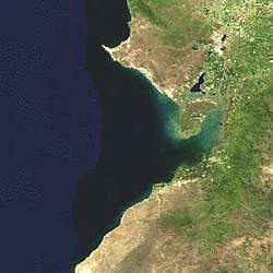
Guayaquil is located on the western bank of the Guayas River, which flows into the Pacific Ocean at the Gulf of Guayaquil.
History
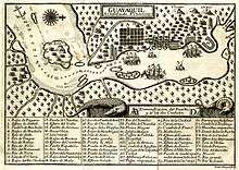
Guayaquil is recognized by the government as having been founded on July 25, 1538[1] with the name Muy Noble y Muy Leal Ciudad de Santiago de Guayaquil (Most Noble and Most Loyal City of St. James of Guayaquil) by Spanish Conquistador Francisco de Orellana. Even before it was founded by the Spanish, it already existed as a native village.
In 1687, Guayaquil was attacked and looted by English and French pirates under the command of George d'Hout (English) and Picard and Groniet (Frenchmen). Of the more than 260 pirates, 35 died and 46 were wounded; 75 defenders of the city died and more than 100 were wounded. The pirates took local women as concubines.
In 1709, the English captains Woodes Rogers, Etienne Courtney, and William Dampier, along with a crew of 110, looted Guayaquil and demanded ransom; however, they suddenly departed without collecting the ransom after an epidemic of yellow fever broke out.
On October 9, 1820, almost without bloodshed, a group of civilians, supported by soldiers from the "Granaderos de Reserva", a battalion quartered in Guayaquil, overwhelmed the resistance of the Royalist guards and arrested the Spanish authorities. Guayaquil declared independence from Spain, becoming Provincia Libre de Guayaquil, and José Joaquín de Olmedo was named Jefe Civil (Civilian Chief) of Guayaquil. This would prove to be a key victory for the Ecuadorian War of Independence.
On July 26, 1822, José de San Martín and Simón Bolívar held a famous conference in Guayaquil to plan for the independence of Spanish South America.
In 1829, the city was invaded by the Peruvian Army, which occupied it for seven months.
In 1860, the city was the site of the Battle of Guayaquil, the last of a series of military conflicts between the forces of the Provisional Government, led by Gabriel García Moreno and General Juan José Flores, and the forces of the Supreme Chief of Guayas, General Guillermo Franco, whose government was recognized as possessing sovereignty over the Ecuadorian territory by Peruvian president Ramón Castilla.
Large portions of the city were destroyed by a major fire in 1896.
On July 8, 1898, the Guayaquil City Hall "Muy Ilustre Municipalidad de Guayaquil" officially recognized the anthem written by José Joaquín de Olmedo in 1821, with the music composed by Ana Villamil Ycaza in 1895, as the "Himno al 9 de Octubre" Canción al Nueve de Octubre, most widely known now as the "Himno a Guayaquil" (Guayaquil Anthem).
Economy
Guayaquileños' main sources of income are: formal and informal trade, business, agriculture and aquaculture. Most commerce consists of small and medium businesses, adding an important informal economy occupation that gives thousands of guayaquileños employment.[2]
The Port of Guayaquil is Ecuador's most important commercial port; most international import and export merchandise passes through the Gulf of Guayaquil. As the largest city in the country, most industries are located either in the city or its peripheral areas.
Ongoing projects seek urban regeneration as a principal objective of the growth of the city's commercial districts, as the increase of capital produces income. These projects in the city driven by the recent mayors have achieved this goal after investing large sums of money. The current municipal administration aims to convert Guayaquil into a place for first-class international tourism and multinational businesses.[3]
Government
Guayaquil's current mayor is Jaime Nebot. He began a campaign of construction projects for the city in the early 2000s to attract tourism, that included the "urban regeneration" plan which reconstructed the city's main tourist streets' sidewalks and upgraded the city's chaotic transit system with multiple infrastructure projects (speedways, overhead passages, tunnels, etc.).
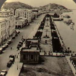
In August 2006, the city's first rapid transit bus system, Metrovia, opened to provide a quicker, high-capacity service. One of the main projects was called Malecón 2000 [maleˈkon doz ˈmil], the renovation of the waterfront promenade (malecón) along the Guayas River. Another project was the creation of the Nuevo Parque Histórico, a park in a housing development area that is called Entre Ríos because it lies between the Daule and Babahoyo Rivers (which merge to form the Guayas River), in a mangrove wetland area. The park cost the city about 7 million dollars.
In 2013, the national government led by Rafael Correa built two pedestrian bridges connecting downtown Guayaquil, Santay Island, and the town of Durán, to allow people to make ecotourism trips on a same-day return basis. The two bridges were a big addition to the Guayas River scenery.
Geography
Guayaquil is the nation's largest city and the capital of Guayas Province. It is on the Guayas River about 60 kilometres (40 mi) north of the Gulf of Guayaquil, near the Equator.
Guayaquil is constantly facing tsunami and major earthquake threats due to its soil stratigraphy and location near the Gulf of Guayaquil and the south of North-Andean subduction zone.[4] The city can be easily damaged by earthquake as its weak and compressible soil stratigraphy is composed of deep soft sediments over hard rocks and deposits in a brackish environment. Also, the city itself is strongly affected by the subduction of the active Ecuadorian margin, an intraplate region where active faults locate; and the Guayaquil-Babahoyo strike-slip fault system, formed as the North Andean Block drifts northward.[5] The tsunami threat is caused by the nearby Gulf of Guayaquil which also is one of the major locations on the Earth where earthquakes tend to happen all the time. It has complex tectonic features such as the Posorja and the Jambeli –two major east-west trending detachment systems; the Puna-Santa Clara northeast-southwest trending fault system; and the Domito north-south trending fault system; that have developed since the Pleistocene times. Tsunami threats are only predicted for coastal farming zones, not the main populated areas.[6][7]
Guayaquil city sectors
| Guayaquil City Territorial Organization Number of the sector in reference with the City Map | |||||
| # | Sectors | # | Sectors | # | Sectors |
|---|---|---|---|---|---|
| 1 | 9 de Octubre Este | 25 | Febres Cordero | 49 | Prosperina |
| 2 | 9 de Octubre Oeste | 26 | Floresta | 50 | Puerto Azul Norte |
| 3 | Abel Gilbert | 27 | La Florida | 51 | Puerto Azul Sur |
| 4 | Acuarela | 28 | García Moreno | 52 | Puerto Lisa |
| 5 | Los Álamos | 29 | Garzota | 53 | Quinto Guayas Este |
| 6 | Alborada Este | 30 | Guangala | 54 | Quinto Guayas Oeste |
| 7 | Alborada Oeste | 31 | Guasmo Este | 55 | Río Guayas |
| 8 | Los Almendros | 32 | Guasmo Oeste | 56 | Roca |
| 9 | Las Américas | 33 | Huancavilca | 57 | Rocafuerte |
| 10 | Atarazana | 34 | Isla Trinitaria | 58 | La Saiba |
| 11 | Ayacucho | 35 | Kennedy | 59 | Samanes |
| 12 | Bastión Popular | 36 | Letamendi | 60 | San Eduardo |
| 13 | Batallón del Suburbio | 37 | Luz del Guayas | 61 | Los Sauces |
| 14 | Bellavista | 38 | Mapasingue | 62 | Simón Bolívar |
| 15 | Bolívar | 39 | Miraflores | 63 | Sopeña |
| 16 | Los Ceibos | 40 | Monte Bello | 64 | Sucre |
| 17 | Centenario | 41 | Olmedo | 65 | Tarqui |
| 18 | Cerro del Carmen | 42 | Las Orquídeas Este | 66 | Unión |
| 19 | Cóndor | 43 | Las Orquídeas Oeste | 67 | Urdenor |
| 20 | Cuba | 44 | Paraíso | 68 | Urdaneta |
| 21 | Del Astillero | 45 | Pascuales | 69 | Urdesa |
| 22 | Estero Salado | 46 | Pedro Carbo | 70 | Los Vergeles |
| 23 | Los Esteros | 47 | Las Peñas | 71 | Ximena |
| 24 | La FAE | 48 | La Pradera | 72 | Mirador Norte |
Here you can find the list of Neighborhoods and Parishes of Guayaquil
Demographics
| Historical Populations Guayaquil City Compared with Guayas Province, Canton of Guayaquil, and Guayaquil City[8] | |||
| Census | Guayas Province | Canton of Guayaquil | Guayaquil City |
| 1950 | 582,144 | 331,942 | 258,966 |
| 1962 | 979,223 | 567,895 | 510,804 |
| 1974 | 1,512,333 | 907,013 | 823,219 |
| 1982 | 2,038,454 | 1,328,005 | 1,199,344 |
| 1990 | 2,515,146 | 1,570,396 | 1,508,444 |
| 2001 | 4,509,034 | 2,148,779 | 1,985,379 |
| Source: Instituto Nacional de Estadisticas y Censos |
| Percentage Population Growth of Guayaquil City Compared with Guayas Province, Canton of Guayaquil, and Guayaquil City.[8] | |||
| Census | Guayas Province | Canton of Guayaquil | Guayaquil City |
| 1950–1962 | 4.34% | 4.49% | 5.67% |
| 1962–1974 | 3.77% | 4.06% | 4.14% |
| 1974–1982 | 3.52% | 4.50% | 4.44% |
| 1982–1990 | 2.63% | 2.10% | 2.87% |
| 1990–2001 | 2.49% | 2.38% | 2.50% |
| Source: Instituto Nacional de Estadisticas y Censos |
Climate
Guayaquil features a tropical savanna climate (Köppen: Aw). Between January and April, the climate is hot and humid with heavy rainfall, especially during El Niño years when it increases dramatically and flooding usually occurs. The rest of the year (from May through December), however, rainfall is minimal due to the cooling influence of the Humboldt Current, with usually cloudy mornings and afternoons, and evening breezes. Guayaquil, along with most of the coastal region, was impacted by the April 16, 2016 earthquake of 7.8 magnitude. A bridge that was above a major artery, Avenida de las Americas, collapsed in the early evening of April 16, killing two people.
| Climate data for Guayaquil | |||||||||||||
|---|---|---|---|---|---|---|---|---|---|---|---|---|---|
| Month | Jan | Feb | Mar | Apr | May | Jun | Jul | Aug | Sep | Oct | Nov | Dec | Year |
| Record high °C (°F) | 37.2 (99) |
35.4 (95.7) |
37.3 (99.1) |
35.8 (96.4) |
35.2 (95.4) |
35.0 (95) |
34.1 (93.4) |
34.7 (94.5) |
34.4 (93.9) |
35.1 (95.2) |
35.4 (95.7) |
36.7 (98.1) |
37.3 (99.1) |
| Average high °C (°F) | 31.2 (88.2) |
31.2 (88.2) |
32.2 (90) |
32.0 (89.6) |
31.2 (88.2) |
29.8 (85.6) |
29.1 (84.4) |
29.7 (85.5) |
30.5 (86.9) |
30.2 (86.4) |
31.1 (88) |
31.8 (89.2) |
30.8 (87.4) |
| Daily mean °C (°F) | 27.1 (80.8) |
27.3 (81.1) |
28.0 (82.4) |
27.8 (82) |
26.9 (80.4) |
25.7 (78.3) |
25.0 (77) |
25.2 (77.4) |
25.5 (77.9) |
25.6 (78.1) |
26.2 (79.2) |
27.1 (80.8) |
26.5 (79.7) |
| Average low °C (°F) | 23.0 (73.4) |
23.4 (74.1) |
23.7 (74.7) |
23.5 (74.3) |
22.6 (72.7) |
21.5 (70.7) |
20.8 (69.4) |
20.7 (69.3) |
20.5 (68.9) |
20.9 (69.6) |
21.3 (70.3) |
22.4 (72.3) |
22.0 (71.6) |
| Record low °C (°F) | 20.0 (68) |
15.8 (60.4) |
19.9 (67.8) |
19.4 (66.9) |
18.5 (65.3) |
17.6 (63.7) |
17.0 (62.6) |
17.2 (63) |
17.2 (63) |
17.8 (64) |
17.0 (62.6) |
18.0 (64.4) |
15.8 (60.4) |
| Average precipitation mm (inches) | 200.7 (7.902) |
332.0 (13.071) |
315.7 (12.429) |
207.7 (8.177) |
62.6 (2.465) |
34.0 (1.339) |
15.6 (0.614) |
1.2 (0.047) |
1.5 (0.059) |
5.6 (0.22) |
29.1 (1.146) |
68.0 (2.677) |
1,263.2 (49.732) |
| Average precipitation days (≥ 1.0 mm) | 12 | 14 | 15 | 10 | 4 | 1 | 0 | 0 | 0 | 1 | 0 | 2 | 59 |
| Source #1: World Meteorological Organization[9] | |||||||||||||
| Source #2: NOAA[10] | |||||||||||||
Food
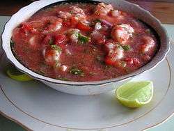
Typical Guayaquil cuisine includes mostly seafood dishes such as encebollado and ceviche. The most traditional dish of Guayaquil is Arroz con Menestra y Carne Asada (rice with lentils and grilled beef).[11] Churrasco is also a staple food of Guayaquil.
During breakfast, Patacones and Bolon de Verde (fried plantain with cheese mashed and given a rounded shape) play a big role. Pan de yuca is a typical snack in Guayaquil. Local cuisine is heavily influenced by the diversity of Guayaquil's ethnic groups which includes Italian, Spanish and West African origins.
Notable people
Artists
Ecuador is known for its artists and its place in art history. Many of them were born in Guayaquil, such as:
- Alfredo Pareja Diezcanseco (1908, Guayaquil – d. 1993, Quito)
- Araceli Gilbert (b. 1913, Guayaquil – d. 1993, Quito)
- Demetrio Aguilera Malta (b. 1909, Guayaquil – d. 1981, Mexico)
- Enrique Gil Gilbert (1912, Guayaquil – d. 1973, Guayaquil)
- Enrique Tábara (b. 1930, Guayaquil)
- Eugenia Viteri (b. 1928, Guayaquil)
- Félix Arauz (b. 1935, Guayaquil)
- Joaquín Gallegos Lara (b. 1909, Guayaquil – d. 1947, Guayaquil)
- Jorge Velarde (b. 1960, Guayaquil)
- José de la Cuadra (1903, Guayaquil – d. 1941, Guayaquil)
- José Martínez Queirolo (b. 1931, Guayaquil – d. 2008, Guayaquil)
- Juan Villafuerte (b. 1945, Guayaquil – d. 1977, Barcelona, Spain)
- Julio Jaramillo (b. 1935, Guayaquil – d. 1978, Guayaquil)*
- Luis Burgos Flor (b. 1939, Guayaquil)
- Luis Miranda (b. 1932, Guayaquil)
- Luis Molinari (b. 1929, Guayaquil)
- Numa Pompilio Llona (b. 1832, Guayaquil – d. 1907, Guayaquil)
- Theo Constanté (b. 1934, Guayaquil)
- Víctor Manuel Rendón (b. 1859, Guayaquil – d. 1940, Guayaquil)
- Xavier Blum Pinto (b. 1957, Guayaquil)
Others
Other notable people from Guayaquil include:
- Fernanda Cornejo, Miss Ecuador International 2011, Miss International 2011
- Olga Álava, Miss Ecuador Earth 2011, Miss Earth 2011
- Sir Frederick Ashton, British choreographer and dancer
- Novelist Demetrio Aguilera Malta
- Animator Mike Judge
- Poets Karina Galvez[12] and Adalberto Ortiz
- Writer/historian Jenny Estrada
- color commentator for the WWE Spanish team and former professional wrestler Hugo Savinovich
- Scholar Benjamín Urrutia
- Former world's oldest person María Capovilla
- Archeologist Presley Norton Yoder
- Violinist Alex Jimbo Viteri
- Violinist Jorge Saade
- Writer Pedro Jorge Vera
- Actor Albert Paulsen
- Operatic soprano Beatriz Parra Durango
- rapper Gerardo Mejía, made famous during the early 1990s for his song "Rico Suave"
- Tennis player Pancho Segura who in 1950 and 1952 was the world's Co-No. 1 player
- Tennis player Andrés Gómez, who won the ATP Championship of Roland Garros in Paris, France in 1990
- Swimmer Jorge Delgado, fourth in the 1972 Munich Olympic Games, multiple times South American champion (19), Gold Medal 1975 Panamerican champion.
- Striker Felipe Caicedo, who is currently playing for RCD Espanyol.
- Striker Joao Plata, who is currently playing for Real Salt Lake.
- Prima ballerina and choreographer Noralma Vera Arrata
- Writer and feminist Rosa Borja de Ycaza
- Writer and educator Rita Lecumberri
Education
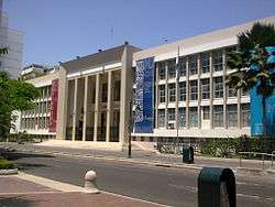
Biblioteca Municipal de Guayaquil (Municipal Library of Guayaquil) serves as the public library of Guayaquil.[13] The city has several universities, including the University of Guayaquil (founded in 1867), the Universidad Catolica de Santiago de Guayaquil, the Escuela Superior Politecnica del Litoral (ESPOL), and the Universidad de Especialidades Espiritu Santo.
Religion
The oldest and largest religion in Guayaquil is the Roman Catholic Church. However, in the late 20th century and early 21st century, the fastest growing religion has been the Church of Jesus Christ of Latter-day Saints, which has an operating Temple in Guayaquil, a future temple in Quito, plus many stakes, wards and branches. There are also a number of Evangelical and Pentecostal churches.
Sports

There are two major association football clubs; the Barcelona Sporting Club and the Club Sport Emelec. Each club has its own stadium; the Estadio Monumental Banco Pichincha is the home of the "Barcelonistas" while the Estadio George Capwell is the home of the "Emelecistas". These two teams have a long history of rivalry in Guayaquil and when these two teams play against each other the game is called "El Clásico del Astillero".
The city is the birthplace of Francisco Segura Cano; and Andrés Gómez and Nicolás Lapentti, Ecuador's two most famous tennis players, now both retired. The "Abierto de Tenis Ciudad de Guayaquil" is a tennis tournament organised in Guayaquil by Gómez and Luis Morejon, and held annually in November.
Another major event in the city is the Guayaquil Marathon, which has been held every year on the first weekend of October since 2005. These race is certified by the (AIMS) Association of International Marathons and Distance Races.
The Parque Samanes is a sports park with courts for soccer, tennis, volleball, and basketball, two lakes, a soccer stadium and an amphi theatre for open air concerts and events. It is connected to a forest reserve with trails for cycling and walking, as well as installations for Climbing and zip-lining.
Universities
Some of Guayaquil's main universities are:
- Escuela Superior Politécnica del Litoral
- Universidad de Especialidades Espíritu Santo
- University of Guayaquil
- Universidad Católica de Santiago de Guayaquil
- Universidad Laica Vicente Rocafuerte
- Universidad Casa Grande
- Universidad Tecnológica Ecotec
- Universidad Santa María
- Blue Hill College
- Universidad Del Pacífico – Ecuador
- Institute of Graphics Arts and Digital Science
- Universidad Politécnica Salesiana
Notable places
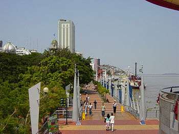
The Malecón 2000 is a restoration project of the historic Simón Bolívar Pier. It will be a symbolic centre of the city, a mix of green areas and shopping. The tall ship Guayas has its home base here.
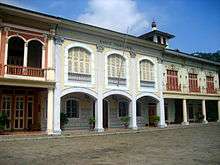
The Palacio Municipal is located in front of the Malecón and holds the political offices of city and provincial officials. Built in a neoclassical style, it is considered one of the most important architectural works in the country.
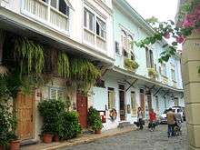
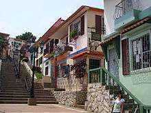
El Barrio las Peñas is a neighbourhood in the northeast corner of the city centre; is the artistic centre of the city. Many of the area's 400-year-old houses have been converted into art galleries and several notable artists have studios in the area.
The Mercado Artesanal is the largest artisan market in the city. The market is housed in a 240-shop building that takes up an entire block.
Parque Centenario is located on Av. 9 de Octubre, between Lorenzo de Garaycoa and Pedro Moncayo. This is the largest park in the town centre, occupying four city blocks. A large Statue of Liberty dominates the central area of the park.
Parque Seminario (also known as Parque de Las Iguanas or Iguana Park) is home to many iguanas (Iguana iguana),[14] some of which approach 5 feet (1.5 m) in length. Tourists and locals alike often feed the iguanas mango slices from park vendors. An equestrian statue of Simón Bolívar is located in the centre of the park.
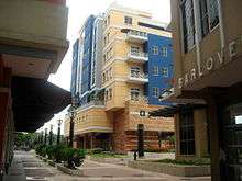
Urdesa is a traditional neighborhood, for stores and restaurants in Guayaquil .
There are a number of forest reserves in and around the city, among them Cerro Blanco Forest, nearby Parque Lago with a big lake where cayaking is practised, Cerro Colorado with the botanical garden, the forest reserve of Samanes, Cerro Paraíso with a viewpoint, the small park Palo Santo in the city, and at the outskirts Papagayo, Prosperina, and Bosqueira.[15] Close to the city there are Isla Santay and the Parque Histórico in Samborondón with a zoo.
Montañita (also known as "Little Amsterdam") is a small surfer town located in Santa Elena Península. Known for its nightlife, Montañita attracts thousands of tourists from all over the world (mainly Western Europe) with its incessant partying, affordable food and drinks, and its key location by the beach.
Tourist attractions
Being Guayaquil the largest city of Ecuador, It has a large variety of both formal and entertainment activities.
Transport
Guayaquil is located along national Highway 40 and is near Highway 25.
Among Guayaquil's major trading points are the seaport, the largest in Ecuador and one of the biggest handlers of shipping on the shores of the Pacific; and José Joaquín de Olmedo International Airport.
José Joaquín de Olmedo International Airport, though using the same runways, had its passenger terminal completely rebuilt in 2006 and was renamed. The old passenger terminal is now a convention centre.[16]
Guayaquil is served by a bus rapid transit system, Metrovia, which opened in 2006. The system has three lines and is supplemented by 35 feeder routes, carrying a total of 400,000 daily passengers.[17]
Sister cities
- Buenos Aires Argentina
- Genoa, Italy
- Houston, United States (1987)[18]
- Santiago, Chile
See also
- Casa del Hombre Doliente – care facility for those suffering a terminal illness
- Damien House
- Newspapers of Guayaquil
References
- ↑ July 25, is a legal holiday in Guayaquil. Historians have not yet reached a consensus about the date of Guayaquil's foundation or founder. The city might have been founded more than once. Another possible founder might be Diego de Almagro.
- ↑ Guayaquil y como el mercado siempre aparece: El retorno de los ‘informales’, Diario Expreso
- ↑ Proyecto de Regeneración Urbana de Guayaquil, artículo "¿Por qué Guayaquil requería regeneración urbana?" de la M. I. Municipalidad de Guayaquil
- ↑ Ioualalen, M.; Monfret, T.; Béthoux, N.; Chlieh, M.; Adams, G. Ponce; Collot, J.-Y.; Bustamante, C. Martillo; Chunga, K.; Navarrete, E. (2014-05-09). "Tsunami mapping in the Gulf of Guayaquil, Ecuador, due to local seismicity". Marine Geophysical Research. 35 (4): 361–378. doi:10.1007/s11001-014-9225-9. ISSN 0025-3235.
- ↑ Vera-Grunauer, X.; J.D., Bray; Pestana, J.M.; Kayen, R.; Tandazo, E.; Ramire, J.; Vera-Grunauer, J.G.; Mera-Ortiz, W. (2006). "Site Characterization and Seismic Zonation of Guayaquil City, Ecuador" (PDF). 8th US National Conference on Earthquake Engineering 2006, v 16, p 9672-9681. Retrieved November 13, 2016.
- ↑ Witt, César; Bourgois, Jacques; Michaud, François; Ordoñez, Martha; Jiménez, Nelson; Sosson, Marc (2006-06-01). "Development of the Gulf of Guayaquil (Ecuador) during the Quaternary as an effect of the North Andean block tectonic escape". Tectonics. 25 (3): TC3017. doi:10.1029/2004TC001723. ISSN 1944-9194.
- ↑ Witt, César; Bourgois, Jacques (2010-01-01). "Forearc basin formation in the tectonic wake of a collision-driven, coastwise migrating crustal block: The example of the North Andean block and the extensional Gulf of Guayaquil-Tumbes Basin (Ecuador-Peru border area)". Geological Society of America Bulletin. 122 (1–2): 89–108. doi:10.1130/B26386.1. ISSN 0016-7606.
- 1 2 Evolución de la población de la provincia, Cantón Guayaquil, y de la Ciudad de Guayaquil – Guayas, Censo 2001, Según el Instituto Nacional de Estadisticas y Censos
- ↑ "World Weather Information Service - Guayaquil". Met Office. Retrieved 16 January 2016.
- ↑ "WMO Normals - Guayaquil". NOAA. Retrieved 16 January 2016.
- ↑ achnolt. "El orgullo del pais es la musica". YouTube. Retrieved April 17, 2010.
- ↑ "ÉSE, SU GUAYAQUIL VIEJO" (PDF). Karinagalvez.com. Retrieved 2017-07-08.
- ↑ "Inicio Archived March 29, 2009, at the Wayback Machine.." Biblioteca Municipal de Guayaquil. Retrieved on April 7, 2009.
- ↑ University of Guayaquil Web site retrieved on December 25, 2013.
- ↑ Conectar áreas naturales es el desafío de Guayaquil, Ricardo Zambrano, El Universo, July 23, 2017 (in Spanish)
- ↑ "Archived copy". Archived from the original on January 7, 2011. Retrieved April 1, 2011.
- ↑ "Metrovía pone en celulares datos sobre rutas y paradas" [Metrovía puts route and stop information on cell phones]. El Universo. 16 March 2017. Retrieved 27 December 2017.
- ↑ {http://legacy.sistercities.org/sites/default/files/Houston%2C%20TX%20-%20Guayaquil%2C%20Ecuador.pdf
External links
| Wikimedia Commons has media related to Guayaquil. |

- Municipalidad de Guayaquil
Provincial capitals in Ecuador | ||
|---|---|---|
Within regions, north to south | ||
| Insular |  | |
| Costa | ||
| Sierra | ||
| Oriente | ||