El Oro Province
| El Oro Provincia de El Oro | |||
|---|---|---|---|
| Province | |||
| Province of El Oro | |||
| |||
.svg.png) | |||
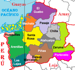 Cantons of El Oro Province | |||
| Country | Ecuador | ||
| Established | April 23, 1884 | ||
| Capital | Machala | ||
| Cantons | List of Cantons | ||
| Area | |||
| • Total | 5,766.68 km2 (2,226.53 sq mi) | ||
| Highest elevation[1] | 3,590 m (11,780 ft) | ||
| Lowest elevation | 0 m (0 ft) | ||
| Population (2010 census) | |||
| • Total | 600,659 | ||
| • Density | 100/km2 (270/sq mi) | ||
| • Urban | 401,940 | ||
| • Population 2001 | 539,888 | ||
| Time zone | UTC-5 (ECT) | ||
| Area code(s) | 07 | ||
| Vehicle registration | O | ||
| Website |
www | ||

El Oro (Spanish pronunciation: [el ˈoɾo]; oro = gold) is the southernmost of Ecuador's coastal provinces. It was named for its historically important gold production. Today it is one of the world's major exporters of bananas. The capital is Machala.
History
El Oro province is historically the major area of banana production in Ecuador.
Geography
To the north and east the province has borders with the provinces Guayas, Azuay and Loja. To the west and south it is limited by the Pacific Ocean and the Peruvian Tumbes Region.
The province is divided in 14 cantons and features a wide range of attractions, such as the Jambelí Islands, the petrified forest of the Puyango River, and the island of Santa Clara, to name a few.
Demographics
- Population 1990: 412,572
- Population 2000: 525,763
- Population 2010: 600,659
Ethnic groups as of the Ecuadorian census of 2010:[2]
- Mestizo 81.6%
- White 7.8%
- Afro-Ecuadorian 6.9%
- Montubio 2.8%
- Indigenous 0.7%
- Other 0.3%
Economy
El Oro economy is mainly based on export of banana and shrimp. Other agricultural products of importance are cacao and coffee.
Politics
Unicameral government.
Cantons
The province is divided into 14 cantons. The following table lists each with its population at the 2001 census, its area in square kilometres (km²), and the name of the canton seat or capital.[3]
| Canton | Pop. (2001) | Area (km²) | Seat/Capital |
|---|---|---|---|
| Arenillas | 22,477 | 803 | Arenillas |
| Atahualpa | 5,479 | 278 | Paccha |
| Balsas | 5,348 | 69 | Balsas |
| Chilla | 2,665 | 328 | Chilla |
| El Guabo | 41,078 | 603 | El Guabo |
| Huaquillas | 40,285 | 72 | Huaquillas |
| Las Lajas | 4,781 | 297 | La Victoria |
| Machala | 217,696 | 338 | Machala |
| Marcabelí | 4,930 | 147 | Marcabelí |
| Pasaje | 62,959 | 452 | Pasaje |
| Piñas | 23,246 | 615 | Piñas |
| Portovelo | 11,024 | 282 | Portovelo |
| Santa Rosa | 60,388 | 889 | Santa Rosa |
| Zaruma | 23,407 | 645 | Zaruma |
See also
References
- ↑ "Provincia de El Oro". 2012-01-22.
- ↑
- ↑ Cantons of Ecuador. Statoids.com. Retrieved 4 November 2009.
External links
| Wikimedia Commons has media related to El Oro Province. |
- (in Spanish) Gobierno Provincial Autonomo de El Oro - web site of the El Oro Government
- (in Spanish) Orenses Machala Comunidad Virtual de La Provincia de El Oro - news about El Oro