Ibarra, Ecuador
| Ibarra | ||
|---|---|---|
| City | ||
| San Miguel de Ibarra | ||
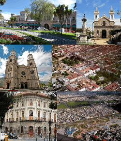 Collage of Ibarra, Top left:La Dolorosa Basilica, Top right:Governorate Paqlace in Pedro Moncayo Park (Parque del Pedro Moncayo), Middle left:View of Chalca Narvaez Avenue, Center:Teodoro Gomez Clock Tower, Middle right:Ibarra Obelisk, Bottom left:View of Capilla Episcopal in Gabriell Garcia Moreno Street, Bottom middle:Statue of San Miguel Ardangel, Bottom right:Santo Domingo Church and Victor Manuel Pencherrana area | ||
| ||
| Nickname(s): La Ciudad Blanca (The White City) | ||
 Ibarra | ||
| Coordinates: 0°21′45.64″N 78°07′50.40″W / 0.3626778°N 78.1306667°WCoordinates: 0°21′45.64″N 78°07′50.40″W / 0.3626778°N 78.1306667°W | ||
| Country | Ecuador | |
| Province | Imbabura | |
| Canton | Ibarra Canton | |
| Founded | 28 September 1606 | |
| Re-founded | 28 April 1872 | |
| Founded by | Cristóbal de Troya y Pinque | |
| Named for | San Miguel de Ibarra | |
| Parishes |
Urban Parishes
| |
| Government | ||
| • Alcalde | Alvaro Castillo | |
| AreaArea of the urban parishes | ||
| • City | 242.02 km2 (93.44 sq mi) | |
| Elevation | 2,225 m (7,300 ft) | |
| Population (2010 census) | ||
| • City | 139,721 | |
| • Density | 580/km2 (1,500/sq mi) | |
| • Metro | 181,175 | |
| Time zone | UTC-5 (ECT) | |
| Postal code | EC100150 | |
| Area code(s) | (+593) 6 | |
| Climate | Csb | |
| Website |
www | |

Ibarra (Spanish pronunciation: [iˈβara]; full name San Miguel de Ibarra) is a city in northern Ecuador and the capital of the Imbabura Province. It lies at the foot of the Imbabura Volcano and on the left bank of the Tahuando river. It is about 70 kilometres (43 mi) northeast of Ecuador's capital Quito.
History
Ibarra was founded in 1606 by order of the President of the Royal Audience of Quito, Miguel de Ibarra. The development of the city included the systematic construction of public buildings including an important number of churches but an earthquake in 1868 destroyed most of them. After the devastating earthquake of August 16 1868 the city was re-settled in 1872. Based on its newest date of foundation, Ibarra is the youngest city in Ecuador. The Inca ruler Atahualpa is said to have been born in the Inca settlement of Inca-Caranqui about 2 km from the city.
Helados de paila (handmade ice cream or sorbet and still sold in the markets today) was first made in Ibarra during Incan times (but not by Incas; by the native indigenous), using snow or ice from the nearby Imbabura Volcano (which is no longer snow bound). Using a large bronze pan surrounded by ice shavings, the juices of various fruits are stirred into the pan to freeze.
Ibarra today
Today, Ibarra is a market town popular with tourists. It has mild weather, colonial white-washed houses (giving it the nickname The White City), and cobbled streets.[1] The Santo Domingo church houses a museum holding paintings. The town is the seat of the Roman Catholic Diocese of Ibarra.
Markets are on Saturdays, and the main festival is the Fiesta de los Lagos, which is held on the last weekend of September. Also, two colorful parades known as El Pregón and Virgen del Carmen are held on 16 July every year.
Other town attractions are the many restaurants specializing in local cuisine, along with the clubs, discos and a paragliding club.
Climate
Ibarra features a warm-summer mediterranean climate (Csb) under the Köppen climate classification. This is possible due to the town's high elevation (7,300ft) in the Ecuadorian Andes providing cooler temperatures and a seasonal rain-shadow characteristic. The dry/warm season is technically local winter due to the town's location being south of the Intertropical Convergence Zone from June to September. However, since Ibarra is located just north of the equator this season could be classified as a summer. The highland climate is mild all year round.
| Climate data for Ibarra | |||||||||||||
|---|---|---|---|---|---|---|---|---|---|---|---|---|---|
| Month | Jan | Feb | Mar | Apr | May | Jun | Jul | Aug | Sep | Oct | Nov | Dec | Year |
| Average high °C (°F) | 22.0 (71.6) |
21.8 (71.2) |
22.1 (71.8) |
22.1 (71.8) |
22.4 (72.3) |
22.2 (72) |
22.8 (73) |
23.2 (73.8) |
23.4 (74.1) |
22.7 (72.9) |
22.0 (71.6) |
22.1 (71.8) |
22.4 (72.3) |
| Average low °C (°F) | 10.4 (50.7) |
10.7 (51.3) |
10.7 (51.3) |
11.1 (52) |
10.5 (50.9) |
9.9 (49.8) |
9.4 (48.9) |
9.1 (48.4) |
9.4 (48.9) |
10.3 (50.5) |
10.6 (51.1) |
10.5 (50.9) |
10.2 (50.4) |
| Average rainfall mm (inches) | 40 (1.57) |
54 (2.13) |
73 (2.87) |
92 (3.62) |
65 (2.56) |
35 (1.38) |
14 (0.55) |
16 (0.63) |
35 (1.38) |
73 (2.87) |
75 (2.95) |
51 (2.01) |
623 (24.52) |
| Source: Climate Data | |||||||||||||
Sister Cities:
- Winchester, Kentucky
- Etawah, Uttar Pradesh, India
References
External links
| Wikivoyage has a travel guide for Ibarra. |
Provincial capitals in Ecuador | ||
|---|---|---|
Within regions, north to south | ||
| Insular |  | |
| Costa | ||
| Sierra | ||
| Oriente | ||