Cotopaxi Province
| Cotopaxi | ||
|---|---|---|
| Province | ||
| Province of Cotopaxi | ||
| ||
.svg.png) Location of Cotopaxi in Ecuador. | ||
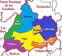 Cantons of Cotopaxi Province | ||
| Coordinates: 0°56′S 78°37′W / 0.933°S 78.617°WCoordinates: 0°56′S 78°37′W / 0.933°S 78.617°W | ||
| Country | Ecuador | |
| Capital | Latacunga | |
| Cantons |
List of Cantons
| |
| Government | ||
| • Provincial Prefect | César Umaginga | |
| Area | ||
| • Total | 6,108.23 km2 (2,358.40 sq mi) | |
| Population (2010 census) | ||
| • Total | 409,205 | |
| • Density | 67/km2 (170/sq mi) | |
| Vehicle registration | X | |
| Website |
www | |

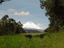
Cotopaxi (Spanish pronunciation: [kotoˈpaksi]) is one of the provinces of Ecuador. The capital is Latacunga. The province contains the Cotopaxi Volcano, an intermittent volcano with a height of 19,388 feet.
Cantons
The province is divided into 7 cantons.[1] The following table lists each canton with its population (per the 2001 census), its area in square kilometres (km²), and the name of the canton seat (capital).[2]
| Canton | Pop. (2001) | Area (km²) | Seat/Capital |
|---|---|---|---|
| La Maná | 32,115 | 647 | La Maná |
| Latacunga | 143,979 | 1,377 | Latacunga |
| Pangua | 19,877 | 715 | El Corazón |
| Pujilí | 60,728 | 1,289 | Pujilí |
| Salcedo | 51,304 | 484 | Salcedo |
| Saquisilí | 20,815 | 206 | Saquisilí |
| Sigchos | 20,722 | 1,267 | Sigchos |
Demographics
Ethnic groups as of the Ecuadorian census of 2010:[3]
- Mestizo 72.1%
- Indigenous 22.1%
- White 2.3%
- Montubio 1.8%
- Afro-Ecuadorian 1.7%
- Other 0.1%
See also
| Wikimedia Commons has media related to Province of Cotopaxi. |
References
- ↑ Danny Palmerlee; Michael Grosberg; Carolyn McCarthy (2006), Ecuador and the Galapagos Islands, Lonely Planet, ISBN 174104295X
- ↑ Cantons of Ecuador. Statoids.com. Retrieved 4 November 2009.
- ↑
External links
- (in Spanish) Gobierno Provincia de Cotopaxi, official website
- Cotopaxi Tours
This article is issued from
Wikipedia.
The text is licensed under Creative Commons - Attribution - Sharealike.
Additional terms may apply for the media files.