Bolívar Province (Ecuador)
| Bolivar | ||
|---|---|---|
| Province | ||
| Province of Bolivar | ||
| ||
.svg.png) Location of the Bolívar Province in Ecuador. | ||
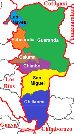 Cantons of Bolívar Province | ||
| Coordinates: 1°36′S 79°0′W / 1.600°S 79.000°WCoordinates: 1°36′S 79°0′W / 1.600°S 79.000°W | ||
| Country | Ecuador | |
| Established | 1827 | |
| Capital | Guaranda | |
| Cantons | List of Cantons | |
| Area | ||
| • Total | 3,945.38 km2 (1,523.32 sq mi) | |
| Population (2010 census) | ||
| • Total | 183,641 | |
| • Density | 47/km2 (120/sq mi) | |
| • Population 2001 | 173,840 | |
| Time zone | UTC-5 (ECT) | |
| Vehicle registration | B | |
| Website |
www | |

Bolívar (Spanish pronunciation: [boˈliβaɾ]) is a province in Ecuador. The capital is Guaranda. Much of the province has a cool, 'sierra' climate, but the part in the lower foothills has a cold, tundra like climate.
Cantons
The province is divided into 7 cantons. The following table lists each with its population as of the 2010 census, its area in square kilometres (km²), and the name of the canton seat or capital.[1]
| Canton | Pop. (2010) | Area (km²) | Seat/Capital |
|---|---|---|---|
| Caluma | 13,129 | 176.54 | Caluma |
| Chillanes | 17,406 | 662.67 | Chillanes |
| Chimbo | 15,779 | 261.42 | Chimbo |
| Echeandía | 12,114 | 230.33 | Echeandía |
| Guaranda | 91,877 | 1,892.08 | Guaranda |
| Las Naves | 6,092 | 148.82 | Las Naves |
| San Miguel | 27,244 | 573.52 | San Miguel |
Demographics
Ethnic groups as of the Ecuadorian census of 2010:[2]
- Mestizo 69.6%
- Indigenous 25.4%
- White 2.7%
- Montubio 1.1%
- Afro-Ecuadorian 1.1%
- Other 0.1%
Politics
Results of the Ecuadorian presidential elections of 2013 in Bolívar Province:[3]
- Rafael Correa (PAIS) 33.7%
- Guillermo Lasso (CREO) 27.7%
- Lucio Gutiérrez (PSP) 25.4%
- Mauricio Rodas (SUMA) 4.9%
- Alberto Acosta (UPI) 4.2%
- Álvaro Noboa (PRIAN) 2.4%
- Norman Wray (Ruptura 25) 1.0%
- Nelson Zavala (PRE) 0.8%
See also
References
External links
This article is issued from
Wikipedia.
The text is licensed under Creative Commons - Attribution - Sharealike.
Additional terms may apply for the media files.