Orellana Province
| Orellana | ||
|---|---|---|
| Province | ||
| Province of Orellana | ||
| ||
.svg.png) Location of Orellana Province in Ecuador. | ||
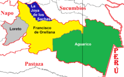 Cantons of Orellana Province | ||
| Country | Ecuador | |
| Established | July 28, 1998 | |
| Founded by | Alejandro Labaca | |
| Named for | Francisco de Orellana | |
| Capital | Puerto Francisco de Orellana | |
| Cantons | List of Cantons | |
| Area | ||
| • Total | 21,692.10 km2 (8,375.37 sq mi) | |
| Population (2010 census) | ||
| • Total | 136,396 | |
| • Density | 6.3/km2 (16/sq mi) | |
| Time zone | UTC-5 (ECT) | |
| Vehicle registration | D | |
| Website |
www | |

Orellana (Spanish pronunciation: [oɾeˈʝana]) is an inland province of Ecuador. The capital is Puerto Francisco de Orellana (also known as Coca). It was created on July 30, 1998, from part of Napo Province.
The name of the province derives from the explorer Francisco de Orellana who it is told to have sailed from somewhere near the town to the Atlantic Ocean. He did this trip several times looking for the gold city of El Dorado and in search of a rumored Nutmeg forest which at the time was a very expensive spice. During his voyages he met a ferocious tribe of Indians who attacked his ships and many among them were women. This led to the naming of the river as the Amazon river. The province is divided in four cantons.
Cantons
The province is divided into four cantons. The following table lists each with its population at the 2001 census, its area in square kilometres (km²), and the name of the canton seat or capital.[1]
| Canton | Pop. (2001) | Area (km²) | Seat/Capital |
|---|---|---|---|
| Aguarico | 4,658 | 11,358 | Nuevo Rocafuerte |
| Francisco de Orellana | 42,010 | 6,995 | Puerto Francisco de Orellana (Coca) |
| Joya de los Sachas | 26,363 | 1,195 | La Joya de los Sachas |
| Loreto | 13,462 | 2,127 | Loreto |
Demographics
Ethnic groups as of the Ecuadorian census of 2010:[2]
- Mestizo 57.5%
- Indigenous 31.8%
- Afro-Ecuadorian 4.9%
- White 4.4%
- Montubio 1.2%
- Other 0.2%
Economy
Jungle composes most of the province's territory, forcing it to rely primarily on exports of crude oil, and timber. Its second most important source of income is tourism, offering jungle exploration, indigenous encounters, and rivers. Mining is the third reliable source of income.
Places of interest
See also
References
- ↑ Cantons of Ecuador. Statoids.com. Retrieved 4 November 2009.
- ↑