Kat O

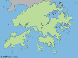
Kat O (Chinese: 吉澳) or Crooked Island is an island in Northeast Hong Kong. Administratively, it is part of North District.
Geography
Kat O is located in the west of Mirs Bay.[1] With an area of 2.35 km²,[2] it is the largest island in North District, the second largest being Wong Wan Chau (Double Island).[3] Neighbouring islands include: Ap Chau, Ngo Mei Chau (Crescent Island), Pak Sha Chau (Round Island), Wong Wan Chau. The village of Tung O (東澳) is located on its northwest coast.[3] Its highest point is Kai Kung Leng (雞公嶺), 122 m above sea level.[1]
History
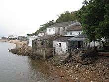
Kat O was once a major fishing market in Hong Kong.[4]
Historic buildings
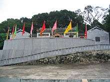
The Tin Hau Temple at Kat O was built in 1763.[5] It is listed as a Grade III historic building.[6]
Conservation
Kat O is part of the Plover Cove (Extension) Country Park since 1979.[7]
Kat O Geoheritage Centre at No.142, Kat O Main Street, Kat O, was opened in 2010[8] by Kat O villagers, voluntary groups and the government to raise public awareness of geo-conservation, as part of the Hong Kong Geopark.[9]
See also
References
- 1 2 Hong Kong Geopark: Kat O Nature Trail
- ↑ Survey and Mapping Office, Lands Department: Hong Kong geographic data sheet
- 1 2 K.W. Lai, S.D.G. Campbell & R. Shaw, Geology of the Northeastern New Territories, p. 15, Civil Engineering Dept, Geotechnical Engineering Office, December 1996
- ↑ Brief Information on proposed Grade III Items. Item #974 Archived 2013-09-22 at the Wayback Machine.
- ↑ Welcome to 18 Districts - North District
- ↑ List of the 1,444 Historic Buildings in Building Assessment (as of 27 December 2013)
- ↑ Agriculture, Fisheries and Conservation Department: Plover Cove Country Park Archived 2013-09-29 at the Wayback Machine.
- ↑ Time Out Hong Kong: "Secret Hong Kong islands", 29 Apr 2014
- ↑ Hong Kong Geopark: Kat O Geoheritage Centre
External links
| Wikimedia Commons has media related to Crooked Island, Hong Kong. |
- Kut-O Chinese Association (Kent area) Website
- Pictures of Kat O: ,
- Hong Kong Geopark: "Lee Yuk Ying Introduces the Cultural History of Kat O to Visitors".
- Webpage about Kat O
Coordinates: 22°32′28″N 114°17′43.9″E / 22.54111°N 114.295528°E