Peng Chau
| 坪洲 | |
|---|---|
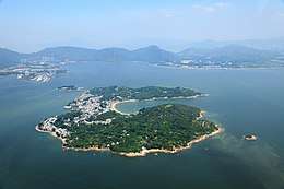 Peng Chau from above | |
 | |
| Geography | |
| Location | West of Hong Kong |
| Area | 0.99 km2 (0.38 sq mi) |
| Highest elevation | 95 m (312 ft) |
| Highest point | Finger Hill |
| Administration | |
| District | Islands District |
| Constituency | Peng Chau and Hei Ling Chau |
| Elected Member (District Council) | Josephine Tsang Sau-ho |
| Demographics | |
| Population | 6,487 (2016) (includes Hei Ling Chau)[1] |
| Peng Chau | |||||||||
| Traditional Chinese | 坪洲 | ||||||||
|---|---|---|---|---|---|---|---|---|---|
| |||||||||
Peng Chau (Chinese: 坪洲) is a small island located off the north-eastern coast of Lantau Island, Hong Kong. It is known for its temples, its small island lifestyle and accessibility to fresh seafood.
Geography
Peng Chau has an area of 0.99 square kilometres (0.38 square miles). The tallest point of the island is Finger Hill, which is 95 metres (312 feet) in height and provides hiking opportunities for those who seek them.
In 2003, the island was undergoing land degradation restorative work.
Features
There are several temples on Peng Chau, including:
- Tin Hau temple (天后廟), built in 1792
- Golden Flower Shrine, dedicated to Lady Kam Fa (金花娘娘)[2]
- Lung Mo Temple (龍母廟)[3]
- Seven Sisters Temple (仙姐廟)[4]
The island is also the site of the, now defunct, Peng Chau Theatre (坪洲戲院).
There are remains of the Sing Lei Hap Gei Lime Kiln Factory, established in the 19th century, and the Great China Match Company Factory, built in 1938.[5]
Climate
| Climate data for Peng Chau (2004–2016) | |||||||||||||
|---|---|---|---|---|---|---|---|---|---|---|---|---|---|
| Month | Jan | Feb | Mar | Apr | May | Jun | Jul | Aug | Sep | Oct | Nov | Dec | Year |
| Record high °C (°F) | 25.8 (78.4) |
27.1 (80.8) |
28.7 (83.7) |
30.3 (86.5) |
33.6 (92.5) |
34.6 (94.3) |
35.4 (95.7) |
35.5 (95.9) |
35.8 (96.4) |
34.0 (93.2) |
30.4 (86.7) |
27.0 (80.6) |
35.8 (96.4) |
| Average high °C (°F) | 18.4 (65.1) |
19.4 (66.9) |
21.4 (70.5) |
24.9 (76.8) |
28.4 (83.1) |
30.2 (86.4) |
31.1 (88) |
31.1 (88) |
30.7 (87.3) |
28.2 (82.8) |
24.7 (76.5) |
20.3 (68.5) |
25.8 (78.4) |
| Daily mean °C (°F) | 15.4 (59.7) |
16.5 (61.7) |
18.6 (65.5) |
22.1 (71.8) |
25.6 (78.1) |
27.6 (81.7) |
28.2 (82.8) |
27.9 (82.2) |
27.5 (81.5) |
25.4 (77.7) |
21.9 (71.4) |
17.5 (63.5) |
22.9 (73.2) |
| Average low °C (°F) | 13.2 (55.8) |
14.6 (58.3) |
16.6 (61.9) |
20.2 (68.4) |
23.8 (74.8) |
25.6 (78.1) |
25.9 (78.6) |
25.7 (78.3) |
25.3 (77.5) |
23.4 (74.1) |
19.8 (67.6) |
15.1 (59.2) |
20.8 (69.4) |
| Record low °C (°F) | 2.5 (36.5) |
6.5 (43.7) |
7.5 (45.5) |
11.0 (51.8) |
18.7 (65.7) |
20.2 (68.4) |
21.7 (71.1) |
22.4 (72.3) |
19.6 (67.3) |
15.5 (59.9) |
8.9 (48) |
5.2 (41.4) |
2.5 (36.5) |
| Source: Hong Kong Observatory[6] | |||||||||||||
Transportation
The main mode of transportation on the island is the bicycle, or on foot. There are no motor cars on the island with the exception of those used by the emergency services. There are also some construction vehicles, and village vehicles are used for the transport of goods around the island.
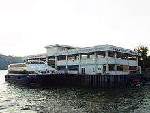
Peng Chau is accessible by a ferry (Hong Kong and Kowloon Ferry) from Central on Hong Kong Island, or by ferries from Cheung Chau via Mui Wo and Chi Ma Wan (New World First Ferry), or by Kai-to ferries from Discovery Bay on Lantau Island. Helicopters are sometimes used in medical emergencies.
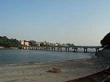
Peng Chau is linked to Tai Lei Island by a bridge. The bridge is part of Peng Lei Road. It is a popular fishing spot.
Famous people
Hong Kong footballer Lee Kin Wo lives on Peng Chau with his family.
See also
References
- ↑ "Population by Year and District Council/ Constituency Area". 2016 Census - Interactive Data Dissemination Service. Census and Statistics Department. Retrieved 15 May 2018.
- ↑ Hong Kong Tourism Board: Golden Flower Shrine
- ↑ Hong Kong Tourism Board: Lung Mo Temple
- ↑ Hong Kong Tourism Board: Seven Sisters Temple
- ↑ "FactoryFormer Lime Kiln and Match Factory". Discover Hong Kong. Hong Kong Tourism Board. Retrieved 7 September 2018.
- ↑ "Extract of Annual Data - Peng Chau, 2004-2016". Hong Kong Observatory. Retrieved January 16, 2017.
External links
| Wikimedia Commons has media related to Peng Chau. |
- Peng Chau page at the Hong Kong Tourism Board.
- Simple Life in Peng Chau - TV program by the Radio Television Hong Kong on Peng Chau (video archive).
- Green Peng Chau Association
- Les copains d'abord Cafe boutique
- Aerial video
Coordinates: 22°17′7″N 114°2′19″E / 22.28528°N 114.03861°E