Ap Lei Chau
| 鴨脷洲 | |
|---|---|
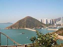
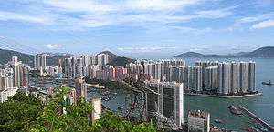 Ap Lei Chau viewed from Hong Kong Trail Stage 2, in the Hong Kong Island, across Aberdeen Harbour. (2008) | |
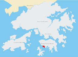 Location of Ap Lei Chau within Hong Kong | |
| Geography | |
| Location | South of Hong Kong Island |
| Coordinates | 22°14′30″N 114°9′20″E / 22.24167°N 114.15556°ECoordinates: 22°14′30″N 114°9′20″E / 22.24167°N 114.15556°E |
| Area | 1.3 km2 (0.50 sq mi) |
| Highest elevation | 196 m (643 ft) |
| Highest point | Yuk Kwai Shan (玉桂山) |
| Administration | |
| District | Southern District |
| Demographics | |
| Population | 86,782 (2007[1]) |
| Pop. density | 66,755 /km2 (172,895 /sq mi) |
| Ap Lei Chau | |||||||||||||||||
| Traditional Chinese | 鴨脷洲 | ||||||||||||||||
|---|---|---|---|---|---|---|---|---|---|---|---|---|---|---|---|---|---|
| Simplified Chinese | 鸭脷洲 | ||||||||||||||||
| Literal meaning | Duck tongue island | ||||||||||||||||
| |||||||||||||||||
Ap Lei Chau (Chinese: 鴨脷洲), or Aberdeen Island, is an island of Hong Kong, located off Hong Kong Island, next to Aberdeen Harbour and Aberdeen Channel, with an area of 1.30 square kilometres (0.50 sq mi).[2] Administratively, it is part of Southern District. Ap Lei Chau is the second most densely populated island in the world.
History
On a map dating from the Ming dynasty, the island is shown, together with a village with the name "Heung Kong Tsuen", the literal meaning of which in Chinese is "Fragrant Harbour Village" (香港村). This is probably the origin of the name "Hong Kong".
Before the First Opium War, Ap Lei Chau was essentially a fishing village. As a consequence of the Treaty of Nanking, it was in 1841 ceded to the British together with Hong Kong Island.
Since then, little attention had been paid to this small island, although Ap Lei Chau does shelter Aberdeen Harbour, creating an excellent natural typhoon shelter.
In 1968, Hongkong Electric opened a power station on Ap Lei Chau to provide electricity for the whole of Hong Kong Island. In 1980 and 1994, a bridge was constructed to connect the island to the Hong Kong Island, and this created momentum for rapid economic development. Public housing estates were built to accommodate people, including some who had suffered in a fire in the Aberdeen shelter.
In 1989, the generators of the power station were relocated to Lamma Island, and the old power station was demolished. The site was re-developed into the South Horizons residential area, with the addition of some land reclaimed from the sea.
Geography and demographics
Ap Lei Chau was named after the shape of the island, which resembles the tongue of a duck. Ap means duck, Lei means tongue, and Chau means island. The northern part has the highest population, while the southern part of the island is less densely populated.
The highest point on the island is Yuk Kwai Shan (玉桂山; aka. Mount Johnston), with an altitude of 196 metres (643 ft).
It comprises four main residential estates — Lei Tung Estate, Ap Lei Chau Main Street, South Horizons and Ap Lei Chau Estate, each of which comprises several highrise towers. There is an industrial estate on the southern tip of the island.
The population of Ap Lei Chau is 86,782 as of 2007,[3] and its area is 1.30 square kilometres (0.50 square miles), giving it a population density of 66,755 people / km², and making it the second most densely populated island in the world.[4]
Ap Lei Chau also lends its name to the Ap Lei Chau geologic formation, which covers most of Hong Kong Island.[5]
Places of interest
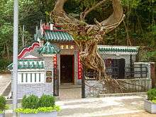
The Hung Shing Temple located on Hung Shing Street, off Main Street, Ap Lei Chau, is a notable site. Dating back to 1773, it is the oldest temple in the Aberdeen and Ap Lei Chau areas[6] and is a declared monument.
The Shui Yuet Temple aka. Kwun Yum Temple is located at No. 181 Main Street, Ap Lei Chau. Dedicated to Guan Yin, it was built at the end of the 19th century[7] and is a Grade III historic building. The temple site is adjacent to the site of the former Aberdeen Police Station. Clearly chosen for its feng shui, the superior dragons were seen as being protection from the 'threat of the tiger's jaw' from the police station. Although the police station has now been demolished, the dragons are still present and seen as enduring feng shui guards. Apart from Guan Yin, the temple also houses Kwan Tai, Tin Hau, Ji Gong and Wong Tai Sin.
Transportation
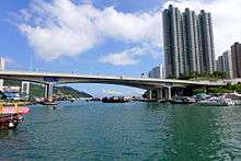
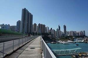
Ap Lei Chau and Hong Kong Island are connected by the four-lane Ap Lei Chau Bridge. Opened in 1983, it originally only had two lanes, and was widened to four in 1994.
Buses are the main form of transport for the residents in Ap Lei Chau. Bus routes depart from the six bus termini on the island to various places on Hong Kong Island and in Kowloon:
- Ap Lei Chau Estate
- Ap Lei Chau (Lee Lok Street) and Ap Lei Chau (Lee King Street) in the industrial area
- Ap Lei Chau Main Street
- Lei Tung Estate
- South Horizons
Green minibuses and taxis are available. Red minibuses are prohibited from entering the island.
There is a regular sampan service running between Ap Lei Chau Main Street and Aberdeen. (Service hours: 6am-12am)
The MTR South Island Line opened on December 28, 2016 links Admiralty of Hong Kong Island to Ap Lei Chau by Aberdeen Channel Bridge. There are two stations on the island: Lei Tung (for Lei Tung Estate and Ap Lei Chau Main Street) and South Horizons (for South Horizons, Ap Lei Chau Estate and Ap Lei Chau Industrial Estate) serving the development of the same name.
See also
References
- ↑ District Council Election 2007 - Southern Archived August 22, 2009, at the Wayback Machine.. The sum of the population in constituency areas D02 to D07
- ↑ Survey and Mapping Office, Lands Department: Hong Kong geographic data sheet
- ↑ District Council Election 2007 - Southern Archived August 22, 2009, at the Wayback Machine.. The sum of the population in constituency areas D02 to D07
- ↑ Island Superlatives
- ↑ Ap Lei Chau Formation Archived September 28, 2007, at the Wayback Machine.
- ↑ Chinese Temples Committee website - Hung Shing Temple, Ap Lei Chau Archived December 12, 2008, at the Wayback Machine.
- ↑ Chinese Temples Committee website - Shui Yuet Temple, Ap Lei Chau Archived July 21, 2011, at the Wayback Machine.
Further reading
- Hayes, James (1971). "Rope-making and Dyeing/Calendering on Ap Lei Chau, Hong Kong" (PDF). Journal of the Hong Kong Branch of the Royal Asiatic Society. 11. Hong Kong. pp. 199–200. Retrieved 15 September 2014.
External links
| Wikimedia Commons has media related to Ap Lei Chau. |