Lamma Island
| 南丫島 | |
|---|---|
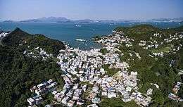 Aerial photo of Yung Shue Wan, Lamma Island | |
 Lamma Island | |
| Geography | |
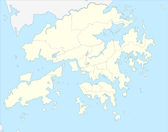
| Location | Southwest of Hong Kong Island |
| Coordinates | 22°12′N 114°07′E / 22.200°N 114.117°ECoordinates: 22°12′N 114°07′E / 22.200°N 114.117°E |
| Area | 13.55 km2 (5.23 sq mi) |
| Length | 7 km (4.3 mi) |
| Highest elevation | 353 m (1,158 ft) |
| Highest point |
Mount Stenhouse 山地塘 |
| Administration | |
|
Hong Kong | |
| Region | New Territories |
| District | Islands District |
| Demographics | |
| Population | 7,000(approx)[1] |
| Ethnic groups | British and Hong Konger |
| Lamma Island | |||||||||||||
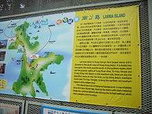 Map of Lamma Island at the ferry pier | |||||||||||||
| Traditional Chinese | 南丫島 | ||||||||||||
|---|---|---|---|---|---|---|---|---|---|---|---|---|---|
| Simplified Chinese | 南丫岛 | ||||||||||||
| |||||||||||||
| Pok Liu Chau | |||||||||||||
| Chinese | 博寮洲 | ||||||||||||
| |||||||||||||
| Pok Liu | |||||||||||||
| Chinese | 博寮 | ||||||||||||
| |||||||||||||
Lamma Island (Chinese: 南丫島), also known as Y Island or Pok Liu Chau (博寮洲) or simply Pok Liu (博寮), is the third largest island in Hong Kong. Administratively, it is part of the Islands District.[2]
Name
Lamma Island was named Lamma only because of a chart reading error by Alexander Dalrymple in the 1760s. He had acquired a Portuguese chart to the entrances to the Pearl River and, close to the west of the island, the Portuguese owner had written "Lama". Dalrymple misinterpreted that as the name of the island. However, it was a Portuguese notation as to the holding (consistency of the seabed from the point of view of anchoring there), which was (and is) mud – in Portuguese "lama". In all the early charts the name was spelled with only one "m". So the island acquired a British name by error and one that subsequently was sinicised by its name being rendered phonetically in characters ("Lam a" can mean "south fork" in Cantonese), with the original muddle being all but forgotten. At some point, things became further obscured by the addition of the second "m" in the English spelling.
In ancient times, Lamma used to be named as Pok Liu or Pok Liu Chau.[3]
Geography
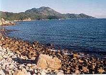
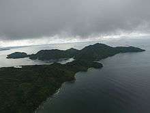
Lamma Island is located to the southwest of Hong Kong Island. It is the third largest island of Hong Kong, with an area of 13.55 km2 (5.23 sq mi)[4] and a length of 7 kilometres (4.3 mi). The northern village is called Yung Shue Wan (Banyan Tree Bay) and the eastern village is called Sok Kwu Wan (Rainbow Bay). Few people live on the southern part of Lamma. Access for much of this part is by hiking or private boat. Sham Wan, an important breeding site for sea turtles, is located there.
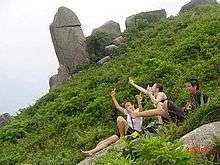
Mount Stenhouse (山地塘, Shan Tei Tong) is the tallest mountain in Lamma 353 metres (1,158 feet) above sea level, situated between Sok Kwu Wan and Sham Wan. Unusually shaped rocks can be found all over this mountain, but a gruelling hike is necessary to access these.
History
According to archaeological findings, human settlement on the northern and eastern part of Lamma Island can be traced back to around 4000–3000 BC,[5] the Middle Neolithic and Bronze Ages. Yung Shue Ha, one of Lamma's earliest villages, was settled in the early 19th century by a clan from China's Bao'an County.
Demographics
Lamma has an estimated population of 5,900 people as of 2014. However, with future developments such as a planned beach community in Sok Kwu Wan the population capacity is expected to double to 11,000 residents.[1]
Actor Chow Yun-fat (周潤發) grew up on the island in the village of Wang Long near Yung Shue Wan. His relatives used to operate a seafood/pigeon restaurant called "Shau Kee" in the main village.[6]
Lamma has a significant Western and international population. The island has had a reputation for alternative lifestyles, hippies, and a relaxed attitude, but Lamma is being urbanised and property prices are increasing as a result of the attraction of this lifestyle.[7]
Description
In contrast to Hong Kong Island and Kowloon, Lamma is peaceful and tranquil with an abundance of natural scenery. Buildings higher than three storeys are prohibited and there are no automobiles but diminutive fire trucks and ambulances, as well as village vehicles; distinctive open-back vehicles to transport construction materials. The community's only means of transport is either by foot or bicycle.
Lamma provides an alternative to the hectic life in the city. Property and rents are cheap compared with those of central Hong Kong. These factors have attracted a significant expatriate community to Lamma Island. It is also popular with younger people and a haven for artists and musicians.
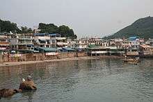
Yung Shue Wan

Yung Shue Wan (Banyan Bay) is the most populated area on Lamma Island. Several decades ago, it was the centre of the plastics industry. The factories have now been replaced by seafood restaurants, pubs, grocery stores and shops which sell oriental and Indian-style handicraft. Hung Shing Yeh Beach, Lamma Power Station and Lamma Winds are also located in the northern part of the island.
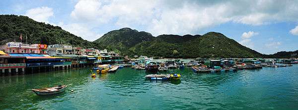
Sok Kwu Wan
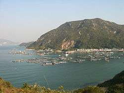
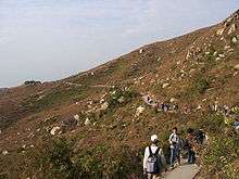
The big street of Sok Kwu Wan consists mainly of seafood restaurants. Sok Kwu Wan has the largest fish farming site in Hong Kong. Tourists can barbecue and fish at Lo Shing Beach which is a ten-minute walk from the village. The trail between Yung Shue Wan and Sok Kwu Wan is surrounded by grassland and offers a picturesque walk. From there one can see a nice portion of the coastline of the island. It takes roughly an hour to walk the trail.
Walkers may notice a few 'caves' on the trail near Sok Kwu Wan, labelled on tourist signs as 'kamikaze grottos'. These caves were dug out by the Japanese during the war, to store munitions alongside the suicide boats. When the British Navy reclaimed Hong Kong, they discovered rows of speedboats with explosive rigged to the bow in Sok Kwu Wan.[8]
In addition to the caves, the Japanese also dug tunnels into the island's peaks, including two known tunnels on Ling Kok Shan[9] and one on Mt. Stenhouse.[10]
Sham Wan
Sham Wan is one of the five most important archaeological sites in Hong Kong. The bay is the site of an important Bronze Age settlement which was unearthed by archaeologists in the 1970s. It yielded evidence of people living on Lamma during the "Middle Neolithic" phase (c. 3800–3000 BC).
It is also a place for green sea turtles to lay eggs. The endangered green turtles are a special group of marine organisms with distinctive navigation behaviour between their nesting, breeding, development and reproduction sites. As Sham Wan is the only existing nesting site for them in Hong Kong, every year there is a period of restricted access to it from 1 June to 31 October to allow the turtles to breed.[11] The breeding site is about 5,100 m2 (54,896 sq ft).
Traditional festivals
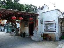
Tin Hau temples are typical places of worship in Hong Kong's coastal communities because Tin Hau is believed to be the goddess of the sea and of fishermen, protecting them and ensuring full nets. There are three Tin Hau temples on Lamma, located in Yung Shue Wan,[12] Sok Kwu Wan,[13] and Luk Chau Village.[14]
The Tin Hau Festival (twenty-third of the third month of the Lunar Calendar) is widely celebrated by the fishermen's communities in Lamma. Cantonese opera and floral paper offerings known as Fa Pau at both Sok Kwu Wan and Yung Shue Wan are the highlights of the celebration.
Lamma Island is also one of the few remaining places in Hong Kong where traditional Chinese New Year celebrations still take place: at the stroke of midnight, fireworks will be set off by the main families of the villages to frighten away the evil spirits, sending off a deafening thunder that can last up to 30 minutes.
Transportation
There are regular ferry services to Yung Shue Wan and Sok Kwu Wan from Central on Hong Kong Island, as well as to Yung Shue Wan via Pak Kok, and to Sok Kwu Wan via Mo Tat Wan, from Aberdeen. It takes about 25 minutes by ferry between Yung Shue Wan and Central. There are no cars on Lamma Island.
Two ferries collided off Yung Shue Wan on 1 October 2012 at 8:20 pm HKT. With 39 killed and 92 injured, the incident was the deadliest maritime disaster in Hong Kong since 1971.[15]
As the island is not connected by road to the rest of Hong Kong, the only vehicles on the island itself are those used by the emergency services, and village vehicles, which are used to transport goods. The main method of getting around the island is on foot or by bicycle.
Notable people
- Chow Yun-fat, actor; born and raised on Lamma Island[16][17][18]
See also
References
- 1 2 Wong, Olga. "Population of Lamma Island will double under new housing plan". South China Morning Post. Hong Kong. Retrieved 13 March 2014.
- ↑ Lamma Island Romance Tour
- ↑ Exploring Lamma – History and Geographical Conditions Hong Kong and Kowloon Ferry
- ↑ Survey and Mapping Office, Lands Department: Hong Kong geographic data sheet
- ↑ Meacham, William (2008). The Archaeology of Hong Kong. Hong Kong University Press. ISBN 978-9622099258.
- ↑ Steinecke, Julia (24 May 2008). "Peaceful origins of actor Chow Yun-Fat". Toronto Star. Hong Kong. Retrieved 7 January 2016.
- ↑ Gotterson, Annie (9 November 2010). "Lamma Island will be a hippie haven no more". CNN Travel. Retrieved 14 April 2011.
- ↑ Scenes in Hong Kong Following the Re-occupation of the Crown Colony after the Japanese Surrender. September 1945 Imperial War Museums
- ↑ Japanese Tunnel, Ling Kok Shan No. 2 Gwulo
- ↑ Japanese Tunnel, Stenhouse Lamma Gwulo
- ↑ Conservation of sea turtles in Hong Kong
- ↑ Exploring Islands – Tin Hau Temple, Yung Shue Wan Archived 13 August 2010 at the Wayback Machine.
- ↑ Exploring Islands – Tin Hau Temple, Sok Kwu Wan Archived 10 June 2011 at the Wayback Machine.
- ↑ Exploring Islands – Luk Chau Tin Hau Temple Archived 10 June 2011 at the Wayback Machine.
- ↑ "List of the 39 deceased in the Lamma ferry disaster". South China Morning Post. 11 January 2013.
- ↑ "Chow Yun-Fat". Biography.com. Retrieved 15 May 2018.
- ↑ Editors of Encyclopaedia Britannica, The (14 May 2018). "Chow Yun-fat". Encyclopaedia Britannica. Retrieved 15 May 2018.
- ↑ "A man of melodrama: Action films made Chow Slightly-Fat famous, but 'The Corruptor' star says he's an actor". The Kansas City Star. 15 March 1999. p. D4. Retrieved 15 February 2010. (Subscription required (help)).
External links
| Wikimedia Commons has media related to Lamma Island. |
| Wikivoyage has a travel guide for Lamma Island. |
- Lamma.com.hk News, Events, Lamma-zine, Stories, Pictures, Forums, Classifieds from & for the Lamma Community & Visitors.
- Lamma Island – Lamma Island page at the Hong Kong Tourism Board.
- More photos of Lamma Island
- "Archaeological Finds on Lamma Island", 1932–1936 article series in The Hong Kong Naturalist by Daniel J. Finn: I, II, III, IV, V, VI, VII, VIII, IX, X, XI, XII, XIII