North District (Hong Kong)
| North 北區 | |
|---|---|
| District | |
| North District | |
 Day view of Long Valley in the North District | |
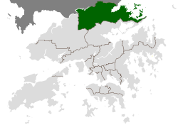 Location of North within Hong Kong | |
| Coordinates: 22°29′41″N 114°08′17″E / 22.49471°N 114.13812°ECoordinates: 22°29′41″N 114°08′17″E / 22.49471°N 114.13812°E | |
| Country |
|
| Region | New Territories |
| Constituencies | 16 |
| Government | |
| • District Council Chairman | So Sai-chi (蘇西智) (DAB) |
| Area | |
| • Total | 168 km2 (65 sq mi) |
| Population (2016) | |
| • Total | 315,270 |
| • Density | 1,900/km2 (4,900/sq mi) |
| Time zone | UTC+8 (Hong Kong Time) |
| Website | North District Council |
| North District | |||||||||||||||
| Traditional Chinese | 北區 | ||||||||||||||
|---|---|---|---|---|---|---|---|---|---|---|---|---|---|---|---|
| Simplified Chinese | 北区 | ||||||||||||||
| Cantonese Yale | Bāk Kēui | ||||||||||||||
| |||||||||||||||
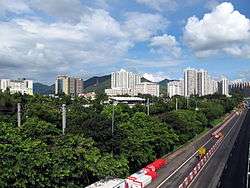
North District (Chinese: 北區; Cantonese Yale: Bāk Kēui) is the northernmost district of the 18 districts of Hong Kong. It is located in the northeastern part of the New Territories. The new town of Fanling-Sheung Shui is within this district. It had a population of 298,657 in 2001. The district has the second lowest population density.
It borders with Shenzhen city with the Sham Chun River. Most major access points to Mainland China from Hong Kong lie in this district. The North District is about 168 km2 (65 sq mi) in area.
Demographics
According to statistics, 70% of the population lives in the public estates in the new town of Fanling-Sheung Shui. 40,000 villagers living around the two centres and another two rural towns Sha Tau Kok and Ta Kwu Ling, account for almost all residents in the district.
Islands of the district
- A Chau (鴉洲)
- Ap Chau Mei Pak Tun Pai (鴨洲尾白墩排)
- Ap Chau Pak Tun Pai (鴨洲白墩排)
- Ap Chau (鴨洲, Robinson Island)
- Ap Lo Chun (鴨螺春)
- Ap Tan Pai (鴨蛋排)
- Ap Tau Pai (鴨兜排)
- Chap Mo Chau (執毛洲)
- Cheung Shek Tsui (長石咀)
- Fu Wong Chau (虎王洲)
- Fun Chau (墳洲)
- Hung Pai (紅排)
- Kat O Chau (吉澳洲, Crooked Island)
- Ko Pai (高排)
- Kok Tai Pai (角大排)
- Lan Shuen Pei (爛樹排)
- Lo Chi Pai (鷀鸕排)
- Ngo Mei Chau (娥眉洲, Crescent Island)
- Pak Ka Chau (筆架洲)
- Pak Sha Chau (白沙洲, Round Island)
- Pat Ka Chau (筆架洲)
- Sai Ap Chau (細鴨洲)
- Sha Pai (沙排)
- Shau Kei Pai (筲箕排)
- Sheung Pai (雙排)
- Shui Cham Tsui Pai (水浸咀排)
- Siu Nim Chau (小稔洲)
- Ta Ho Pai (打蠔排)
- Tai Nim Chau (大稔洲)
- Tsing Chau (青洲)
- Wong Nai Chau (黃泥洲)
- Wong Nai Chau (黃泥洲)
- Wong Wan Chau (往灣洲, Double Island)
- Wu Chau (烏洲)
- Wu Pai (烏排)
- Wu Yeung Chau Pai (湖洋洲排)
- Yan Chau (印洲)
- Yeung Chau (洋洲)
Miscellaneous
The northern end of the Wilson Trail hiking path is located in the North District. The trail ends at Nam Chung.
Transport
North District is served by MTR East Rail Line, Fanling Highway, San Tin Highway and Sha Tau Kok Road.
MTR Stations
- Fanling Station
- Sheung Shui Station
- Lo Wu Station (terminus of East Rail Line)
Border crossings
- Sha Tau Kok (road)
- Man Kam To (road)
- Lo Wu (train)
See also
External links
- North District District Council
- List and map of electoral constituencies 1 (large PDF file)
- List and map of electoral constituencies 2 (large PDF file)
- Fanling-Sheung Shui New Town
- Satellite image of the new town of Fanling-Sheung Shui and its vicinity by Google Maps
Places adjacent to North District (Hong Kong) | ||||||||||
|---|---|---|---|---|---|---|---|---|---|---|
| ||||||||||