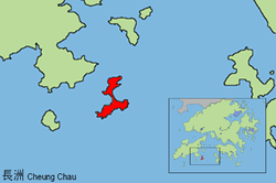
Cheung Chau
 Cheung Chau (2013) | |
 | |
| Geography | |
|---|---|
| Location | Southwest of Hong Kong |
| Coordinates | 22°12′38″N 114°01′44″E / 22.210556°N 114.028889°ECoordinates: 22°12′38″N 114°01′44″E / 22.210556°N 114.028889°E |
| Area | 2.46 km2 (0.95 sq mi) |
| Highest elevation | 95 m (312 ft) |
| Administration | |
| District | Islands District |
| Demographics | |
| Population | 22,740 (2011) |
| Pop. density | 9,882.93 /km2 (25,596.67 /sq mi) |
| Ethnic groups | British and Hong Konger (total 95.58%) |
| Cheung Chau | |||||||||
| Traditional Chinese | 長洲 | ||||||||
|---|---|---|---|---|---|---|---|---|---|
| |||||||||
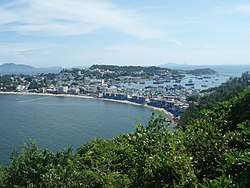
Cheung Chau (Chinese: 長洲, lit. "Long state") is an island 10 kilometres (6.2 miles) southwest of Hong Kong Island. It is nicknamed the 'dumbbell island (啞鈴島)' due to its shape. It has been inhabited for longer than most other places in the territory of Hong Kong, and had a population of 22,740 as of 2011.[1] Administratively, it is part of the Islands District.
Geography
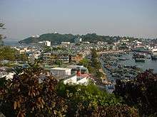
Geographically the island is formed from two mostly granite masses joined by a tombolo. With an area of 2.45 square kilometres (0.95 square miles),[2] the island is therefore "long", hence the name as translated from Cantonese is "Long Island". Thus, it is redundant to say "Cheung Chau Island". The island is dumbbell-shaped, with hills at the northern and southern ends and the settlements concentrated in between.
Economy
The central part of the island is well developed with shops and houses. The lane-ways are so narrow that normal motor traffic is impossible. Instead, there are small motorised trucks officially termed "village vehicles". For example, there are small specially designed mini-fire engines, ambulances and police cars. Residential areas also exist on the hills of the north and south.
Traditionally the island was a fishing village and there are still fishing fleets working from the harbour. However, in recent years the island has become a major tourist attraction, offering a mixture of sandy swimming beaches, seafood cafés, and traditional Chinese culture.
History
Under the terms of the 1898 Second Convention of Peking, the New Territories and 200 smaller islands including Cheung Chau were leased to the United Kingdom for 99 years. At that time, Cheung Chau was mainly a fishing village; it had more residents living on junks than on land. Cheung Chau had already been settled by people from other places in Southern China; for example, Hoklo, they are mainly fishing people; Hakka people; Chiu Chau; and Yue Ca. The island slowly evolved into a commercial hub with merchants selling supplies to the local fishing people, boat repair and fishing gear as well as the place to do business for fishing people and small farmers of other nearby islands like Lantau Island.
From 2000, a spate of suicide cases (most of them by "burning charcoal") took place inside rental holiday homes on the island. Hong Kong Chinese-language newspapers soon dubbed the island "Death Island" and stories concerning apparitions appeared in the wake of news about the succeeding suicides. In 2005 a local councillor Lam Kit-sing (林潔聲) proposed a "suicide theme-park" to be built to capitalise on the island's now macabre reputation. Those plans were quickly ridiculed and subsequently rejected. Soon after, the choice of Cheung Chau for would-be suicides tailed off.
Sights
Temples
Temples on Cheung Chau include:[3]
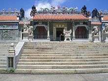
- Pak Tai Temple – one of the oldest temples in Hong Kong. The temple was built in 1783. It was demolished and completely rebuilt in 1989. In front of the temple, there are 4 pairs of guarding lions. Before the altar are statues of two generals, "Thousand Miles Eye" (千里眼) and "Favourable Wind Ear" (順風耳), who together are traditionally said to be able to hear and see everything
- Four temples dedicated to Tin Hau
- Hung Shing Temple. Built in 1993, it is managed by the Chinese Temples Committee.[4]
- Kwan Kung Chung Yi Ting, a traditional temple built in 1973, dedicated to the god of justice Kwan Tai
- Kwun Yam Temple (觀音廟) aka. Shui Yuet Temple (水月宮) aka. Chi Kung (子宮), near Kwun Yam Wan beach. Built before 1840, and dedicated to Guanyin (Kwun Yam), it gave its name to the nearby bay Kwun Yam Wan.[5]
Others
- Tung Wan and Kwun Yam Wan beaches
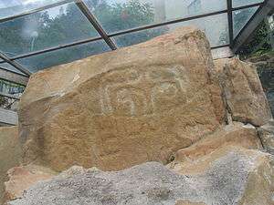
- Rock carvings located near Tung Wan Beach were reported by geologists in 1970, and are declared monuments of Hong Kong.[6][7] This 3000-year-old rock carving is located on the east of the island, immediately below the Warwick Hotel. It consists of two groups of similar carved lines surrounding small depressions.
- A Cheung Po Tsai Cave, alleged to be the hiding place of Cheung Po Tsai, a 19th-century pirate
- Cheung Chau Mini Great Wall, a hiking trail
Culture
Festivals
| Date (Chinese Lunar Calendar) | Festival |
|---|---|
| 1st day of 1st month | Lunar New Year |
| 15th day of 1st month | Lantern Festival |
| 3rd day of 3rd month | Yuen Mo's Birthday |
| 18th day of 3rd month | Birthday of Tin Hau |
| 8th day of 4th month | Bun Festival |
| 5th day of 5th month | Tuen Ng Festival (Dragon Boat Festival) |
| 24th day of 6th month | Birthday of Kwan Tai |
| 15th day of 8th month | Mid-Autumn Festival |
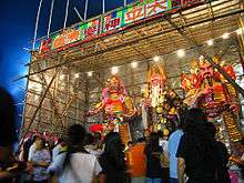
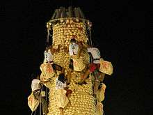
Bun Festival
The annual Cheung Chau Bun Festival is a festival which includes a parade of floats, most famously including young children dressed as famous characters doing impossible balancing acts.[8] It last three to four days and attracts tens of thousands of visitors to the island.
Education
There are currently three primary schools in Cheung Chau, including C.C.C. Cheung Chau Church Kam Kong Primary School, Cheung Chau Sacred Heart School, Kwok Man School, and two secondary schools : Buddhist Wai Yan Memorial College and Cheung Chau Government Secondary School. Formerly there were 7 primary schools including the Fisheries Joint Association Public School, Shun Dal Primary School and The Cheung Chau Government Primary School and three secondary schools including the now closed Caritas Saint Paul's secondary school. Although there are more people living on Cheung Chau now than ever, the fertility rate throughout Hong Kong has dropped significantly leading to many school closings throughout the city.
Notable people
- Lee Lai Shan, a windsurfer, won Hong Kong's first Olympic gold medal in 1996. That Olympic gold was also Hong Kong's last Olympic medal since in 1997 Hong Kong became a Special Administrative Region of the People's Republic of China and now competes in the Olympics as Hong Kong, China.
- Vincent Lee Kwun Leung Lee (李冠良), a visual artist
Climate
| Climate data for Cheung Chau (1993–2016) | |||||||||||||
|---|---|---|---|---|---|---|---|---|---|---|---|---|---|
| Month | Jan | Feb | Mar | Apr | May | Jun | Jul | Aug | Sep | Oct | Nov | Dec | Year |
| Record high °C (°F) | 28.4 (83.1) |
29.6 (85.3) |
30.6 (87.1) |
34.6 (94.3) |
34.6 (94.3) |
34.2 (93.6) |
37.0 (98.6) |
35.9 (96.6) |
36.1 (97) |
33.8 (92.8) |
33.2 (91.8) |
28.9 (84) |
37.0 (98.6) |
| Average high °C (°F) | 19.6 (67.3) |
20.0 (68) |
22.0 (71.6) |
25.4 (77.7) |
28.6 (83.5) |
30.1 (86.2) |
30.8 (87.4) |
30.6 (87.1) |
30.2 (86.4) |
28.7 (83.7) |
25.5 (77.9) |
21.4 (70.5) |
26.1 (79) |
| Daily mean °C (°F) | 15.8 (60.4) |
16.6 (61.9) |
18.8 (65.8) |
22.2 (72) |
25.5 (77.9) |
27.2 (81) |
27.8 (82) |
27.5 (81.5) |
26.9 (80.4) |
25.1 (77.2) |
21.7 (71.1) |
17.5 (63.5) |
22.7 (72.9) |
| Average low °C (°F) | 13.4 (56.1) |
14.4 (57.9) |
16.6 (61.9) |
20.2 (68.4) |
23.5 (74.3) |
25.3 (77.5) |
25.7 (78.3) |
25.5 (77.9) |
24.8 (76.6) |
22.9 (73.2) |
19.4 (66.9) |
15.0 (59) |
20.6 (69.1) |
| Record low °C (°F) | 1.9 (35.4) |
4.3 (39.7) |
6.4 (43.5) |
10.3 (50.5) |
15.7 (60.3) |
19.7 (67.5) |
21.8 (71.2) |
22.1 (71.8) |
19.8 (67.6) |
14.7 (58.5) |
8.3 (46.9) |
4.5 (40.1) |
1.9 (35.4) |
| Average precipitation mm (inches) | 25.4 (1) |
27.0 (1.063) |
51.4 (2.024) |
123.9 (4.878) |
226.1 (8.902) |
330.0 (12.992) |
253.1 (9.965) |
314.4 (12.378) |
182.7 (7.193) |
53.7 (2.114) |
36.1 (1.421) |
23.5 (0.925) |
1,647.3 (64.854) |
| Average rainy days (≥ 0.5 mm) | 3.7 | 5.5 | 7.3 | 8.6 | 11.8 | 16.3 | 15.6 | 14.6 | 10.5 | 4.1 | 3.5 | 4.0 | 105.4 |
| Average relative humidity (%) | 75 | 81 | 84 | 87 | 88 | 90 | 90 | 89 | 83 | 76 | 74 | 70 | 82 |
| Source: Hong Kong Observatory[9] | |||||||||||||
Transportation


First Ferry operates ferries service between Central pier number 5 and Cheung Chau. The ferries run approximately every 30 minutes depending upon time of day. Schedules on Sundays and public holidays differ from weekdays. The trip of about 20 kilometres (12 miles) takes 55 minutes or 35 minutes for ordinary ferries and high speed ferries respectively. Ferries operated by Maris Ferry to Aberdeen are also available.
Due to inaccessibility to cars and other vehicles, most residents use bicycles for personal transportation, and a number of bicycle rental shops near the ferry pier rent bicycles to tourists. The only vehicles on the island are those used by the emergency services, as well as village vehicles used to transport goods.
See also
References
- ↑ "普查結果 | 2011年香港人口普查". www.census2011.gov.hk. Retrieved 2016-01-13.
- ↑ Survey and Mapping Office, Lands Department: Hong Kong geographic data sheet
- ↑ (in Chinese) Cheung Chau Temples
- ↑ Chinese Temples Committee: Hung Shing Temple, Cheung Chau Archived 3 March 2016 at the Wayback Machine.
- ↑ Brief Information on proposed Grade Nil Items. Item #1272
- ↑ Antiquities and Monuments Office: Rock Carvings on Cheung Chau
- ↑ S.G. Davis, Shirlee Edelstein, Madeleine H. Tang, "Rock Carvings in Hong Kong and the New Territories", 26 September 1973
- ↑ Cheung Chau Bun Festival
- ↑ "Monthly Means of Meteorological Elements for Cheung Chau, 1993-2016". Hong Kong Observatory. Retrieved February 8, 2017.
External links
| Wikimedia Commons has media related to Cheung Chau. |
- Cheung Chau Island – Cheung Chau page at Hong Kong Tourism Board
- Chinese Festivals-Hong Kong Tourism Board
- My Hometown – Cheung Chau – TV program by the Radio Television Hong Kong on Cheung Chau. (video archive)
- Hong Kong’s Other Peak – and the City’s Overlooked History of Segregation