Crna River (Vrbas)
| Crna River | |
|---|---|
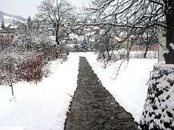 Crna rijeka in Mrkonjić Grad | |
| Native name | Crna rijeka / Црна ријека |
| Country | Bosnia and Herzegovina |
| Physical characteristics | |
| Main source |
Malo Lake (Balkana), Lisina slopes 780 m (2,560 ft) |
| River mouth |
Vrbas 44°27′59″N 17°10′44″E / 44.4663°N 17.1789°ECoordinates: 44°27′59″N 17°10′44″E / 44.4663°N 17.1789°E |
| Length | 17 km (11 mi) |
| Basin features | |
| Progression | Vrbas→ Sava→ Danube→ Black Sea |
Crna River (Bosnian: Crna rijeka / Црна ријека, "Black River") is left tributary of Vrbas. It arises from Malo Lake (Malo jezero, "Little Lake", 780 m) of Balkana, Mrkonjić Grad Municipality. The lake fed by streams Cjepalo (1320 m) and Skakavac with mountain Lisina, as well as sublacustric sources under the Veliko Lake (Veliko jezero, "Great Lake").[1][2][3][4]
The river flows in the direction south-north and on the way runs through the town, and after a flow of 17 km flows into the Vrbas (at places Dabrac). It used to be known for numerous fish species and developed the sport fishing.[5]
References
- ↑ http://www.kartabih.com/
- ↑ Vojnogeografski institut, Ed. (1962): Banja Luka (List karte 1:100.000, Izohipse na 20 m). Vojnogeografski institut, Beograd.
- ↑ Mučibabić B., ed. (1998). Geografski atlas Bosne i Hercegovine. Sarajevo: Geodetski zavod BiH. ISBN 9958-766-00-0.
- ↑ Spahić M. et al. (2000): Bosna i Hercegovina (1:250.000). Izdavačko preduzeće „Sejtarija“, Sarajevo.
- ↑ „Turistički vodič Mrkonjić Grada“, Udruženje za razvoj i unapređenje turizma općine Mrkonjić Grad, 2010.
This article is issued from
Wikipedia.
The text is licensed under Creative Commons - Attribution - Sharealike.
Additional terms may apply for the media files.